

You are here
Avalanche Forecast for 2019-02-09 06:30
- EXPIRED ON February 10, 2019 @ 6:30 amPublished on February 9, 2019 @ 6:30 am
- Issued by Nick Meyers - Shasta-Trinity National Forest
Bottom Line
LOW danger this morning will rise rapidly following the onset of a cold winter storm tracking toward the area today. Wind slab, storm slab and loose-dry avalanche danger will increase over the next 24-48 hours. CONSIDERABLE danger is possible late today, and likely tonight. New snow will fall on a variety of existing snow surfaces. Tread lightly out there and pay attention. Carry rescue gear and know how to use it. Dangerously cold wind chill temperatures are certain. Be prepared.


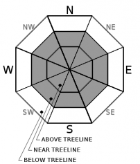
Avalanche Problem 1: Wind Slab
-
Character ?

-
Aspect/Elevation ?
-
Likelihood ?CertainVery LikelyLikelyPossible
 Unlikely
 -
Size ?HistoricVery LargeLargeSmall

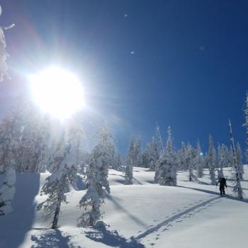
Once again, wind slabs lead the charge for our avalanche problems today. Low danger this morning will rapidly rise as new snow and southwesterly winds kick in. Existing instabilities have been hard to come by and wind slabs unreactive to triggers. Any avalanches today are expected to be within the new snow. Areas of drifting snow may begin to form, even before snowfall begins. The majority of wind slabs will form near and above treeline on NW-N-NE-E-SE aspects. Isolated wind slabs could form in other locations as well due to local orographics. Avalanche size up to D2 (large enough to bury, injure or kill a person) is possible by late this afternoon in heavily wind loaded areas. Wind slabs will become more widespread overnight as new, low density snow combines with wind.
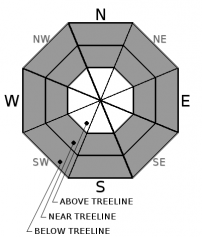
Avalanche Problem 2: Storm Slab
-
Character ?

-
Aspect/Elevation ?

-
Likelihood ?CertainVery LikelyLikelyPossible
Unlikely
-
Size ?HistoricVery LargeLargeSmall
Storm slabs will be possible late in the storm cycle today and/or tonight where more than 6-8 inches of snow has accumulated. Storm slabs are most likely in steep, sheltered, windless areas below and near treeline, all aspects. With typically a short lifespan, they are usually the easiest to trigger during periods of heavy snow. Storm slabs can be difficult to recognize since the snow surface is often soft and powdery. Reduce your risk from storm slabs by identifying slope steepness, new snow accumulation and staying off steep slopes for a day or two after the storm.
Avalanche Problem 3: Loose Dry
-
Character ?

-
Aspect/Elevation ?
-
Likelihood ?CertainVery LikelyLikelyPossible
Unlikely
-
Size ?HistoricVery LargeLargeSmall
Cold, dry snow on steep slopes > 35 degrees may result in small to medium size loose-dry avalanches late in the day or early tomorrow morning when new snow really begins to pile up. Most loose dry avalanches stabilize within a few hours or days. Human triggering of loose-dry avalanches is most common. Because this is a surface problem, it is easy to feel and recognize unconsolidated snow. Loose-dry avalanches are often times relatively harmless, but on larger slopes can entrain a significant amount of snow. Paired up with a terrain trap, it is possible to be buried. Expert riders in very steep terrain can use sluff-management techniques.
Forecast Discussion
Unusually cold temperatures this weekend may result in uncommon avalanche hazard for our maritime snowpack. Longer lasting instabilities and poor bonding of new and old snow are two examples. Play it safe out there as a bitter cold winter storm envelopes Northern California. Wintery weather is set for the next week as well. Snow will be measured in feet, not inches. Who's excited?
Recent Observations
- Yesterday was a hold-over day with no new and notable observations.
- Winds have been light out of the west/southwest
- Temperatures ranged from 11 to 15 degrees F at 8,000 feet.
- A trace of new snow overnight.
- No new avalanches were reported
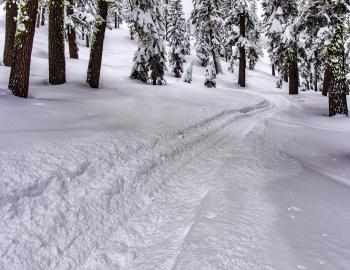
- Evidence of wind affected snow is widespread, near and above treeline. One will find textured wind packed powder, variable crusts, wild sastrugi formations, smooth and soft powder as well as bulletproof ice
- Wind slabs near and above treeline ranged from 6 inches to 2 feet thick.
- Soft snow totals below treeline were 1.5 to 2.5 feet deep.
- All snow rests on top of our January 19th rain on snow event ice layer.
Weather and Current Conditions
Weather Summary
Precipitation has been slow to start, but today is the day. Cold air and snow is moving into the area this morning. We're looking at about .75 inches of water by close of business Sunday. Snow levels will fall below town. Windy conditions are certain near and above treeline out of the southwest. Today is the windiest, but moderate to strong winds are going to persist through the weekend, gradually swinging around to the west and northwest. Tonight will be very cold and wind chill temperatures on the mountain....yes, downright frigid. Longer term, Valentines week will host a cold and very active weather pattern that will bring heaps of snow to the mountains.
24 Hour Weather Station Data @ 5:00 AM
| Weather Station | Temp (°F) | Wind (mi/hr) | Snow (in) | Comments | ||||||||
|---|---|---|---|---|---|---|---|---|---|---|---|---|
| Cur | Min | Max | Avg | Avg | Max Gust | Dir | Depth | New | Water Equivalent | Settlement | ||
| Mt. Shasta City (3540 ft) | 30 | 27 | 36 | 30.5 | 1 | N | ||||||
| Sand Flat (6750 ft) | 18 | 16 | 24 | 19 | 86 | 0 | 0 | 2 | ||||
| Ski Bowl (7600 ft) | 14 | 12 | 16.5 | 14 | 106 | 0 | 0 | 0 | ||||
| Gray Butte (8000 ft) | 13 | 11 | 15 | 13.5 | 7 | 25 | WNW | |||||
| Castle Lake (5870 ft) | 20 | 18.5 | 28.5 | 22 | 69 | 0 | 0 | |||||
| Mount Eddy (6509 ft) | 18 | 12.5 | 21.5 | 17 | 1 | 8 | WSW | 76 | 0 | 2 | ||
| Ash Creek Bowl (7250 ft) | station down | |||||||||||
| Ash Creek Ridge (7895 ft) | station down |
Two Day Mountain Weather Forecast
Produced in partnership with the Medford NWS
| For 7000 ft to 9000 ft | |||
|---|---|---|---|
|
Saturday (4 a.m. to 10 p.m.) |
Saturday Night (10 p.m. to 4 a.m.) |
Sunday (4 a.m. to 10 p.m.) |
|
| Weather | Snow, breezy | Snow tapering off; Snow showers | Snow showers in the AM, becoming mostly cloudy |
| Temperature (°F) | 19 | 6 | 17 |
| Wind (mi/hr) | Southwest 15-20 | Southwest 5-10 | West 5-10 |
| Precipitation SWE / Snowfall (in) | / 8-12 | / 2-3 | / 1 |
| For 9000 ft to 11000 ft | |||
| Saturday | Saturday Night | Sunday | |
| Weather | Snow, heavy at times, windy | Snow tapering off; snow showers, windy. | Snow showers in the AM, cloudy and cold, windy. |
| Temperature (°F) | 6 | -5 | 4 |
| Wind (mi/hr) | Southwest 40-50 | West 8-12 | Northwest 10-20 |
| Precipitation SWE / Snowfall (in) | / 8-12 | / 2-4 | / 1 |
Season Precipitation for Mount Shasta City
| Period | Measured (in) | Normal (in) | Percent of Normal (%) |
|---|---|---|---|
| From Oct 1, 2025 (the wet season) | 16.32 | 24.22 | 67 |
| Month to Date (since Jun 1, 2026) | 2.39 | 1.95 | 123 |
| Year to Date (since Jan 1, 2026) | 7.91 | 9.01 | 88 |

