

You are here
Avalanche Forecast for 2019-02-10 06:30
- EXPIRED ON February 11, 2019 @ 6:30 amPublished on February 10, 2019 @ 6:30 am
- Issued by Aaron Beverly - Mount Shasta Avalanche Center
Bottom Line
Dangerous avalanche conditions exist. Human triggered avalanches are likely. Natural avalanches are possible. Wind slabs, storm slabs, and cornice failures are problems that can be encountered. Stay away from steep slopes, evaluate the snowpack carefully, and make conservative decisions. Be prepared for frigid temperatures.


Avalanche Problem 1: Wind Slab
-
Character ?

-
Aspect/Elevation ?
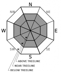
-
Likelihood ?CertainVery LikelyLikelyPossible
 Unlikely
 -
Size ?HistoricVery LargeLargeSmall

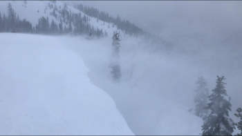
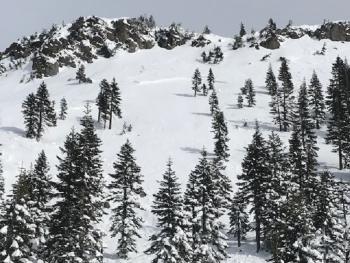
Triggering a wind slab avalanche today is likely. Winds blew steadily at or above 20 mi/hr for 13 hours yesterday and active wind loading was observed. They will continue to transport snow today.
Cracking snow, whumphing sounds, cornices, and smooth wind pillows are some indicators that a wind slab problem exists nearby. Stay off of slopes greater than 35 degrees.
Avalanche Problem 2: Storm Slab
-
Character ?

-
Aspect/Elevation ?
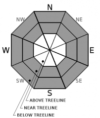
-
Likelihood ?CertainVery LikelyLikelyPossible
Unlikely
-
Size ?HistoricVery LargeLargeSmall
Storm slabs are possible today on all wind-sheltered aspects near 40 degrees.
Storm slabs can be difficult to recognize since the snow surface is often soft and powdery. Reduce your risk from storm slabs by identifying slope steepness, new snow accumulation, and staying off steep slopes for a day or two after the storm.
Avalanche Problem 3: Cornice
-
Character ?

-
Aspect/Elevation ?
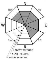
-
Likelihood ?CertainVery LikelyLikelyPossible
Unlikely
-
Size ?HistoricVery LargeLargeSmall
Staying away from cornices is always good advice, but they will be especially touchy today. A falling cornice is likely to trigger a wind slab avalanche. They have a nasty habit of breaking farther back than you expect, so it's best to stay well clear of them.
Forecast Discussion
Conservative decision making is mandatory today. Stick to slopes below 30 degrees.
Be prepared for frigid temperatures. With this unusual cold, the snowpack will not strengthen quickly and new weaknesses may begin to form. A rain crust exists about 26 inches below the snow received over last week. Keep an eye on this interface for developing weakness. We will be.
Although storm slabs are more of a concern today on slopes approaching 40 degrees, loose dry avalanches could also be triggered. These sloughs could knock you off your feet and carry you into undesirable terrain.
Recent Observations
Observations from yesterday saw 4 out of 5 red flags of avalanche danger:
- Recent D1 size avalanches and cornice failures.
- Significant snowfall (8-12 inches in less than 10 hours).
- Active wind loading onto southeast, east, and northeast aspects.
- Cracking.
Columns tests produced easy non-propagating failures within the new snowpack.
The Old Ski Bowl weather station is reporting 10 inches of new snow in the last 24 hours and temperatures ranging from 7 to 17 degrees. Above 20 mi/hr westerly winds persisted for 13 hours near treeline.
Weather and Current Conditions
Weather Summary
Lingering snow showers, cold temperatures, and light to moderate west and northwest winds are expected today, becoming strong tonight.
A new low pressure system will begin to impact the area tomorrow, bringing significant snow Monday night and Tuesday. Wintery conditions will continue throughout the week.
24 Hour Weather Station Data @ 5:00 AM
| Weather Station | Temp (°F) | Wind (mi/hr) | Snow (in) | Comments | ||||||||
|---|---|---|---|---|---|---|---|---|---|---|---|---|
| Cur | Min | Max | Avg | Avg | Max Gust | Dir | Depth | New | Water Equivalent | Settlement | ||
| Mt. Shasta City (3540 ft) | 17 | 17 | 34 | 28 | 2 | N | ||||||
| Sand Flat (6750 ft) | 8 | 8 | 21 | 15 | 91.3 | 5 | 0.08 | 2 | ||||
| Ski Bowl (7600 ft) | 6 | 5.5 | 16.5 | 11 | 115.8 | 11 | 0.27 | 1 | ||||
| Gray Butte (8000 ft) | 5.5 | 4.5 | 15.5 | 10 | 20 | 61 | WNW | |||||
| Castle Lake (5870 ft) | 10 | 9.5 | 27.5 | 17 | 75 | 10.7 | 1 | |||||
| Mount Eddy (6509 ft) | 12.5 | 9 | 21.5 | 15 | 2 | 13 | SSE | 86.4 | 9 | 0 | ||
| Ash Creek Bowl (7250 ft) | station down | |||||||||||
| Ash Creek Ridge (7895 ft) | station down |
Two Day Mountain Weather Forecast
Produced in partnership with the Medford NWS
| For 7000 ft to 9000 ft | |||
|---|---|---|---|
|
Sunday (4 a.m. to 10 p.m.) |
Sunday Night (10 p.m. to 4 a.m.) |
Monday (4 a.m. to 10 p.m.) |
|
| Weather | Snow showers likely, mainly before 10 a.m. Mostly cloudy. Chance of precipitation is 60%. | A 50 percent chance of snow. Mostly cloudy. | Snow likely. Cloudy. Low wind chills. Breezy and gusty. Chance of precipitation is 70%. |
| Temperature (°F) | 17 | 15 | 20 |
| Wind (mi/hr) | West 5-10 | Southwest 5-10 | Southwest 20-25 |
| Precipitation SWE / Snowfall (in) | / 1-2 | / 0-1 | / 0-1 |
| For 9000 ft to 11000 ft | |||
| Sunday | Sunday Night | Monday | |
| Weather | Snow showers likely, mainly before 10 a.m. Cloudy and cold. Sub-zero wind chills. Windy and gusty. Chance of precipitation is 60%. | A 50 percent chance of snow. Mostly cloudy. Sub-zero wind chills. Windy and gusty. | Snow likely. Cloudy and cold. Sub-zero wind chills. Windy and gusty. Chance of precipitation is 60%. |
| Temperature (°F) | 4 | 4 | 13 |
| Wind (mi/hr) | Northwest 15-20 | West 1-2 | Southwest 30-40 |
| Precipitation SWE / Snowfall (in) | / 1-2 | / 0-1 | / 1-2 |
Season Precipitation for Mount Shasta City
| Period | Measured (in) | Normal (in) | Percent of Normal (%) |
|---|---|---|---|
| From Oct 1, 2025 (the wet season) | 16.58 | 24.46 | 68 |
| Month to Date (since Jun 1, 2026) | 2.65 | 2.19 | 121 |
| Year to Date (since Jan 1, 2026) | 8.17 | 9.25 | 88 |

