

You are here
Avalanche Forecast for 2019-02-11 07:00
- EXPIRED ON February 12, 2019 @ 7:00 amPublished on February 11, 2019 @ 7:00 am
- Issued by Aaron Beverly - Mount Shasta Avalanche Center
Bottom Line
Dangerous avalanche conditions persist. Human triggered avalanches are likely. Natural avalanches are possible. Wind slabs and cornice failures are the primary concern today. Stay away from steep wind loaded slopes, evaluate the snowpack carefully, and make conservative decisions. Be prepared for frigid temperatures.


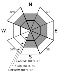
Avalanche Problem 1: Wind Slab
-
Character ?

-
Aspect/Elevation ?
-
Likelihood ?CertainVery LikelyLikelyPossible
 Unlikely
 -
Size ?HistoricVery LargeLargeSmall

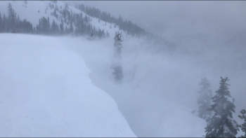
Small wind slabs were reactive to ski triggering yesterday and plenty of shooting cracks and blocking were observed. Strong winds are expected today above treeline which means wind slabs will continue to grow. Take this problem seriously and avoid leeward slopes above 35 degrees.
Cracking snow, whumphing sounds, cornices, and smooth wind pillows are some indicators that a wind slab problem exists nearby.
Avalanche Problem 2: Cornice
-
Character ?

-
Aspect/Elevation ?

-
Likelihood ?CertainVery LikelyLikelyPossible
Unlikely
-
Size ?HistoricVery LargeLargeSmall
Cornices were reactive to ski triggering yesterday and may continue to grow today with strong winds predicted. They have a nasty habit of breaking farther back than you expect, so it's best to stay well clear of them.
Forecast Discussion
Use conservative decision making today. Avalanche danger will increase at treeline and above as you begin to see effects of the wind.
Climbers note that snow surfaces are becoming more scoured and icy on westerly facing slopes. Know how to use your ice axe and crampons. Prepare for frigid temperatures above treeline.
Despite continuous cold temperatures, no faceting has been observed within the snowpack down to the February 2nd rain crust. Column tests have indicated no significant weakness at this interface, though shovel shear tests have shown medium propagating failures so we will continue to monitor it as significant snow this week adds weight to the snowpack.
Recent Observations
Pertinent observations from yesterday:
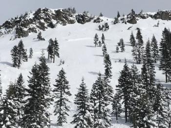
- Ash Creek Butte
- Natural wind slab avalanche, northeast facing, size D2, 100 feet wide, 1-2 feet deep.
- Cornices reactive to ski trigger.
- South facing aspects actively loading.
- Gray Butte:
- Small wind slabs and cornices reactive to ski trigger, slabs 6 - 18 inches
- Shooting cracks and blocking.
- No natural avalanches seen near or above treeline.
- Moderate non-propagating column test failures, moderate shovel shear failure at February 2nd rain crust.
- No signs of faceting down to February 2nd rain crust.
- Moderate to strong westerly winds transporting snow.
- Northwest aspects becoming scoured.
- Above treeline snow surfaces becoming wind affected.
- Ski penetration (PS) / boot penetration (PB): 6 inches / 24 inches.
The Old Ski Bowl weather station reports 1.5 inches of new snow in the last 24 hours and temperatures ranging from 10 to 18 degrees. Productive northwest winds blew for several hours near treeline.

Weather and Current Conditions
Weather Summary
A low pressure system off the coast of Washington will begin to impact the area today. We could get a couple of inches today, a few tonight, and a few tomorrow. Things will get interesting tomorrow night with 7-11 inches of snow expected. Get your shovels and snowblowers ready. Snow levels are going to be delivering the goods to town. Expect continued wintry weather until the end of the week.
South and west winds will be moderate to strong today and tonight.
24 Hour Weather Station Data @ 6:00 AM
| Weather Station | Temp (°F) | Wind (mi/hr) | Snow (in) | Comments | ||||||||
|---|---|---|---|---|---|---|---|---|---|---|---|---|
| Cur | Min | Max | Avg | Avg | Max Gust | Dir | Depth | New | Water Equivalent | Settlement | ||
| Mt. Shasta City (3540 ft) | 27 | 16 | 37 | 25.5 | 1 | N | ||||||
| Sand Flat (6750 ft) | 15 | 6 | 19 | 14 | 90 | 0 | 0 | 0 | ||||
| Ski Bowl (7600 ft) | 11.5 | 4.5 | 17.5 | 11 | 114.5 | 1.5 | 0.02 | 0 | ||||
| Gray Butte (8000 ft) | 10 | 5.5 | 17.5 | 10.5 | 13 | 49 | WNW | |||||
| Castle Lake (5870 ft) | 18 | 9.5 | 31.5 | 17.5 | 73.3 | 0 | 2 | |||||
| Mount Eddy (6509 ft) | 14 | 8 | 18.5 | 13.5 | 2 | 8 | ESE | 83.4 | 0 | 3 | ||
| Ash Creek Bowl (7250 ft) | station down | |||||||||||
| Ash Creek Ridge (7895 ft) | station down |
Two Day Mountain Weather Forecast
Produced in partnership with the Medford NWS
| For 7000 ft to 9000 ft | |||
|---|---|---|---|
|
Monday (4 a.m. to 10 p.m.) |
Monday Night (10 p.m. to 4 a.m.) |
Tuesday (4 a.m. to 10 p.m.) |
|
| Weather | Snow. Low wind chills. Breezy. Chance of precipitation is 80%. | Snow. Low wind chills. Breezy. Chance of precipitation is 90%. | Snow. Low wind chills. Breezy. Chance of precipitation is 100%. |
| Temperature (°F) | 21 | 20 | 21 |
| Wind (mi/hr) | South 15-20 | South 20-25 | South 20-25 |
| Precipitation SWE / Snowfall (in) | / 1-2 | / 2-5 | / 2-4 |
| For 9000 ft to 11000 ft | |||
| Monday | Monday Night | Tuesday | |
| Weather | Snow. Sub-zero wind chills. Windy and gusty. Chance of precipitation is 80%. | Snow. Sub-zero wind chills. Windy and gusty. Chance of precipitation is 90%. | Snow. Sub-zero wind chills. Windy and gusty. Chance of precipitation is 100%. |
| Temperature (°F) | 12 | 11 | 13 |
| Wind (mi/hr) | West 35-45 | Southwest 1-3 | South 45-55 |
| Precipitation SWE / Snowfall (in) | / 1-3 | / 3-6 | / 3-5 |
Season Precipitation for Mount Shasta City
| Period | Measured (in) | Normal (in) | Percent of Normal (%) |
|---|---|---|---|
| From Oct 1, 2025 (the wet season) | 16.58 | 24.69 | 67 |
| Month to Date (since Jun 1, 2026) | 2.65 | 2.42 | 110 |
| Year to Date (since Jan 1, 2026) | 8.17 | 9.48 | 86 |

