

You are here
Avalanche Forecast for 2019-02-27 06:00
- EXPIRED ON February 28, 2019 @ 6:00 amPublished on February 27, 2019 @ 6:00 am
- Issued by Aaron Beverly - Mount Shasta Avalanche Center
Bottom Line
Over 30 inches of snow was received in the last 24 hours. Up to 20 could fall today near and above treeline. Natural and human-triggered avalanches are likely. They could be very large and may travel long distances. Travel in, near, or below avalanche terrain is not recommended.


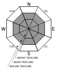
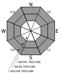
Avalanche Problem 1: Wind Slab
-
Character ?

-
Aspect/Elevation ?
-
Likelihood ?CertainVery LikelyLikelyPossible
 Unlikely
 -
Size ?HistoricVery LargeLargeSmall

Storm totals are at 55 inches and counting. Southerly and westerly winds have blown continously at moderate speeds since Sunday. Wind slabs could be huge. Snow underneath them is a mix of light density snow and crusts. This will not easily support their weight. Wind slabs are likely to be found on northerly and easterly aspects, but variable mountain winds and cross loading could put them in other areas.
When wind slabs are forming, cornices are usually growing. Significant snow and southerly winds will combine to add weight and size to already large cornices. If these break, they'll be big and will likely trigger a wind slab avalanche. Steer well clear of these over the next few days. Look for them primarily at the top of east and north facing slopes.
Pay attention to where leeward areas reside. Stay far away from steep slopes that have been loaded. Look for signs of wind slabs and cornices as you travel in safe terrain:
- Shooting cracks, blocking, whumphing
- Convex pillows of wind-drifted snow
- Chalky, hollow sounding snow
Avalanche Problem 2: Storm Slab
-
Character ?

-
Aspect/Elevation ?

-
Likelihood ?CertainVery LikelyLikelyPossible
Unlikely
-
Size ?HistoricVery LargeLargeSmall
New surface snow yesterday was functioning as a slab. Some weakness within the storm snow was seen, though column tests were inconsistent at triggering this weakness. Enough snow will fall today to keep the concern for this problem elevated.
You may find storm slabs near and below treeline, in wind protected areas, on very steep slopes approaching 40 degrees.
Storm slabs are a release of a soft cohesive layer of new snow that breaks within the storm snow or on the old snow surface. Storm-slab problems typically last between a few hours and few days.
Avalanche Problem 3: Deep Slab
-
Character ?

-
Aspect/Elevation ?
-
Likelihood ?CertainVery LikelyLikelyPossible
Unlikely
-
Size ?HistoricVery LargeLargeSmall
A weak interface was discovered yesterday at the 2/13/19 rain crust. It is not clear if this problem is widespread, but the crust definitely is up to near treeline elevations. Because of the depth of this weakness (at least 100 cm down) it may be difficult for a human to trigger it, but the amount of snow that has fallen in the last 24 hours coupled with another foot or so today, may add enough weight to bring the snowpack to a breaking point. The snow atop this crust acts as a slab that would create a very large avalanche.
Because the 2/13/19 rain crust is unlikely to exist at high elevations, this problem is most likely confined to near and below treeline elevations.
Forecast Discussion
With the sheer amount of snow that has fallen (55 inches total, 30 inches in the last 24 hours) and is expected to fall today and tonight (up to 20 inches), expect some unusual conditions out there. Avalanches could be very large. Runouts may be long. Slabs and cornices could break further back from ridgetops than expected. Avalanches may slide on lower angle slopes than typical. Stick to terrain under 30 degrees. Travel in, near, or below avalanche terrain in not recommended.
Recent Observations
Over the last 24 hours, the Old Ski Bowl has received 30 inches of snow. Temperatures ranged from 23 to 29 degrees. Westerly and southerly winds have been moderate, averaging 17 mi/hr and gusting up to 43.
At the Mount Shasta Ski Park, yesterday's round of new snow, though fist soft, was moist and heavy.
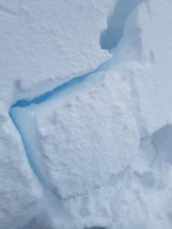
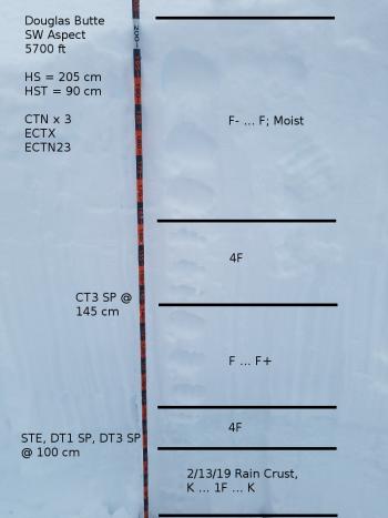
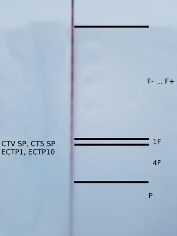
Column tests yielded inconsistent results on a southwest aspect of Douglas Butte at 5,700 feet (CT3 SP @ new/old snow interface, CTNx3). Extended column tests did not propagate and showed no notable failures (ECTX, ECTN23). Deep tap tests and shovel shear tests indicate a concerning weak interface down 105 cm (41 in) at the rain crust from 2/13/19 (STEx2, DT1 SP, DT3 SP). All snow atop this crust including new snow functioned as one slab. See yesterday's observation for details.
Low visibility, deep snow, and closed access limited near and above treeline observations yesterday.
Everitt Memorial and Castle Lake Roads are closed.

Weather and Current Conditions
Weather Summary
The atmospheric river is beginning to dry up, though over 1.5 inches of precipitable water is still expected today and tonight. Things will taper off early tomorrow morning. A winter storm warning remains in effect until 1 a.m. Thursday.
Predictions for snow levels have been off as last night's in town snow proved. Plan on them to be 4,000 feet or lower.
Expect 8-17 inches of snow near and below treeline; 12-20 above treeline. Southerly winds will be moderate to strong.
24 Hour Weather Station Data @ 5:00 AM
| Weather Station | Temp (°F) | Wind (mi/hr) | Snow (in) | Comments | ||||||||
|---|---|---|---|---|---|---|---|---|---|---|---|---|
| Cur | Min | Max | Avg | Avg | Max Gust | Dir | Depth | New | Water Equivalent | Settlement | ||
| Mt. Shasta City (3540 ft) | 35 | 33 | 37 | 34.5 | 4 | ESE | ||||||
| Sand Flat (6750 ft) | station not responding | |||||||||||
| Ski Bowl (7600 ft) | 23 | 22.5 | 28.5 | 25 | 190.3 | 30.8 | 4.7 | 0 | ||||
| Gray Butte (8000 ft) | 22 | 21.5 | 26 | 24 | 16 | 43 | SW | |||||
| Castle Lake (5870 ft) | 27 | 27 | 31.5 | 29.5 | 147.3 | 23.3 | 0.1 | |||||
| Mount Eddy (6509 ft) | ||||||||||||
| Ash Creek Bowl (7250 ft) | station down | |||||||||||
| Ash Creek Ridge (7895 ft) | station down |
Two Day Mountain Weather Forecast
Produced in partnership with the Medford NWS
| For 7000 ft to 9000 ft | |||
|---|---|---|---|
|
Wednesday (4 a.m. to 10 p.m.) |
Wednesday Night (10 p.m. to 4 a.m.) |
Thursday (4 a.m. to 10 p.m.) |
|
| Weather | Snow. Blustery. Chance of precipitation is 100%. | Snow before 10 p.m., then snow showers likely after 10 p.m. Blustery. Chance of precipitation is 90%. | A 40 percent chance of snow showers. Partly sunny. |
| Temperature (°F) | 30 | 17 | 27 |
| Wind (mi/hr) | South 15-20 | Southwest 10-15 | West 5-10 |
| Precipitation SWE / Snowfall (in) | / 5-11 | / 4-8 | / 0 |
| For 9000 ft to 11000 ft | |||
| Wednesday | Wednesday Night | Thursday | |
| Weather | Snow. The snow could be heavy at times. Windy and gusty. Low wind chill values. Chance of precipitation is 100%. | Snow before 10 p.m., then snow showers likely after 10 p.m. The snow could be heavy at times. Windy and gusty. Low wind chills. Chance of precipitation is 90%. | Mostly sunny and cold. Windy and gusty. Low wind chills. |
| Temperature (°F) | 20 | 10 | 10 |
| Wind (mi/hr) | Southwest 35-45 | Southwest 8-13 | West 20-25 |
| Precipitation SWE / Snowfall (in) | / 8-13 | / 4-7 | / 0 |
Season Precipitation for Mount Shasta City
| Period | Measured (in) | Normal (in) | Percent of Normal (%) |
|---|---|---|---|
| From Oct 1, 2025 (the wet season) | 22.13 | 28.42 | 78 |
| Month to Date (since Jun 1, 2026) | 8.20 | 6.15 | 133 |
| Year to Date (since Jan 1, 2026) | 13.72 | 13.21 | 104 |

