

You are here
Avalanche Forecast for 2019-02-28 06:15
- EXPIRED ON March 1, 2019 @ 6:15 amPublished on February 28, 2019 @ 6:15 am
- Issued by Ryan Sorenson - Mount Shasta Avalanche Center
Bottom Line
Nearly five feet of new snow fell over the last four days. Cold temperatures with south and west wind continue to promote elevated avalanche risk today. Natural avalanches are possible and human-triggered avalanches are likely. Avalanches could be very large and may travel long distances. Travel in or below avalanche terrain is not recommended.


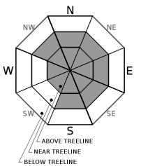
Avalanche Problem 1: Wind Slab
-
Character ?

-
Aspect/Elevation ?
-
Likelihood ?CertainVery LikelyLikelyPossible
 Unlikely
 -
Size ?HistoricVery LargeLargeSmall

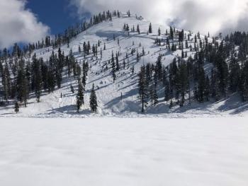
An impressive storm total of 58 inches was recorded at 7,600 feet on Mount Shasta over the last four days. Southerly and westerly winds have blown continuously at moderate speeds since Monday. A three-day average wind speed of 16 mi/hr with gust as high as 43 mi/hr was recorded at 8,000 feet on Gray Butte since Monday. Wind slabs have grown large on NW-N-NE-E-SE-S aspects near treeline. Variable mountain winds and cross loading could allow wind slabs to form on all aspects above treeline. Surface snow is soft and light, and there is plenty of available snow for continued windslab formation.
Continued caution and paying attention to where leeward areas reside will be necessary if venturing out into the backcountry today. Stay far away from steep slopes that have been loaded. Look for signs of wind slabs and cornices as you travel in safe terrain. Stay away from areas where shooting cracks, blocking, and whumphing are observed. Other signs of wind slabs include previously drifted snow and chalky, hollow sounding snow. If wind slabs are encountered keep travel to lower angle windward slopes to return to safety.
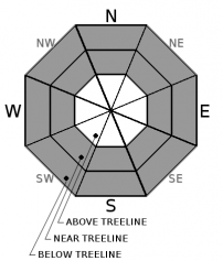
Avalanche Problem 2: Storm Slab
-
Character ?

-
Aspect/Elevation ?
-
Likelihood ?CertainVery LikelyLikelyPossible
Unlikely
-
Size ?HistoricVery LargeLargeSmall
Increasing temperatures observed yesterday has allowed the new storm snow to function as a slab over colder less dense snow from early this week. Blocking, cracking and sluffing in the upper snowpack were all observed on Gray Butte yesterday. These storm slab instabilities should increase in strength and become less likely to trigger as things begin to settle out today. However, continue to avoid steep slopes below and near treeline. You may find storm slabs near and below treeline, in wind protected areas, on very steep slopes approaching 40 degrees. Storm slabs could be large enough to bury a person.
Forecast Discussion
Don't let the excitement of clearing weather and new snow cloud your ability to make safe decisions today. Stay alive by making conservative decisions and remember the five red flags for avalanche danger:
Recent avalanches **
Cracking, blocking, whumphing *
Significant snowfall in 24 hours *
Strong winds **
Temperature rise *
* - Have been observed; ** - are expected today
Recent Observations
A storm total of 58 inches was recorded at 7,600 feet on Mount Shasta over the last four days. The majority of the snow fell on Tuesday, Febuary 26th with an impressive 36 inches recorded over a 24 hour period. Temperatures have ranged from 20-32 degrees since Monday, with the warmest temperatures seen yesterday afternoon.
Moist and heavy snow was observed falling at the Mount Shasta Ski Park yesterday. Deep soft powder with 14-20 inches of ski penetration was seen on Gray Butte. Some shooting cracks and blocking was noticed in the upper snowpack in steeper wind affected terrain. Skiing indicated storm slab potential in top 5 inches. A generally right side up snowpack with Fist to 1F hardness exists near treeline.
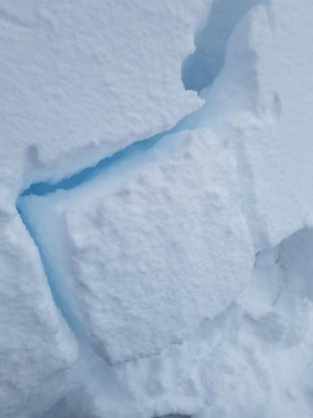
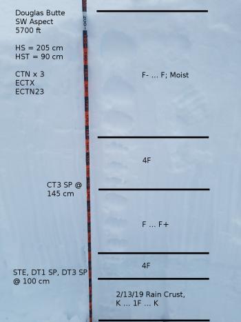
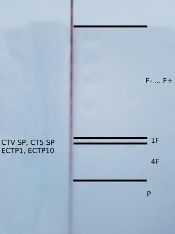
Column tests yielded inconsistent results on a west aspect of Gray Butte at 7,600 feet (CTE SP @ 13 cm, CTH BRK @ 42 cm, CTH RP @ 120cm). Extended column tests did not propagate and showed no notable failures (ECTX). See yesterday's observation for details.
Low visibility, and deep snow limited above treeline observations yesterday.
Everitt Memorial and Castle Lake Roads are closed.
Weather and Current Conditions
Weather Summary
The large winter storm will move east out of the forecast area today giving a short break in the heavy snowfall for the next few days. Though a low-pressure system will remain spinning off the Pacific Northwest coast for the foreseeable future. This low-pressure system will bring a chance for isolated snow showers and cold temperatures for the next few days.
Dry out that puffy jacket if you haven't already. Clearing skies as this system moves to the east mixed with arctic air pushing down from Alaska will allow for temperatures to stay below freezing today. Expect temperatures in the mid 20's below and near treeline today. Temperatures will drop to the low teens above treeline with low wind chills below zero degrees Fahrenheit.
Light wind will continue to blow out of the south-west this morning switching to a more southerly flow this afternoon below and near treeline today. An increasing moderate to strong wind out of the west will blow above treeline throughout the day on Mount Shasta. The Eddies will see light to moderate wind from the west this morning then switching to light southerly wind this afternoon.
24 Hour Weather Station Data @ 6:00 AM
| Weather Station | Temp (°F) | Wind (mi/hr) | Snow (in) | Comments | ||||||||
|---|---|---|---|---|---|---|---|---|---|---|---|---|
| Cur | Min | Max | Avg | Avg | Max Gust | Dir | Depth | New | Water Equivalent | Settlement | ||
| Mt. Shasta City (3540 ft) | 26 | 26 | 42 | 34 | 4 | ESE | ||||||
| Sand Flat (6750 ft) | station not responding | |||||||||||
| Ski Bowl (7600 ft) | 13 | 13 | 32 | 25 | 191 | 4 | 1.53 | 3 | ||||
| Gray Butte (8000 ft) | 12.5 | 12.5 | 30.5 | 23.5 | 15 | 31 | SSW | |||||
| Castle Lake (5870 ft) | 17.5 | 17.5 | 33 | 28.5 | 150.8 | 3 | 2 | |||||
| Mount Eddy (6509 ft) | ||||||||||||
| Ash Creek Bowl (7250 ft) | station down | |||||||||||
| Ash Creek Ridge (7895 ft) | station down |
Two Day Mountain Weather Forecast
Produced in partnership with the Medford NWS
| For 7000 ft to 9000 ft | |||
|---|---|---|---|
|
Thursday (4 a.m. to 10 p.m.) |
Thursday Night (10 p.m. to 4 a.m.) |
Friday (4 a.m. to 10 p.m.) |
|
| Weather | Partly cloudy with isolated snow showers. A 20 percent chance of snow | Increasing clouds and cooler temperatures. A 20 percent chance of snow | Becoming mostly cloudy with isolated snow showers. A 40 percent chance of snow. |
| Temperature (°F) | 30 | 17 | 31 |
| Wind (mi/hr) | Southwest 5-10 | South 5-10 | South 5-10 |
| Precipitation SWE / Snowfall (in) | / 0-1 | / 0-1 | / 0-2 |
| For 9000 ft to 11000 ft | |||
| Thursday | Thursday Night | Friday | |
| Weather | Mostly sunny with isolated snow showers in the morning. A 20 percent chance of snow. Low wind chill. | Increasing clouds and low temperatures. A 20 percent chance of snow. Low wind chills. | Mostly cloudy with isolated snow showers. A 40 percent chance of snow. |
| Temperature (°F) | 12 | 10 | 12 |
| Wind (mi/hr) | Southwest 20-25 | West 0-1 | West 20-25 |
| Precipitation SWE / Snowfall (in) | / 0-1 | / 0-1 | / 0-1 |
Season Precipitation for Mount Shasta City
| Period | Measured (in) | Normal (in) | Percent of Normal (%) |
|---|---|---|---|
| From Oct 1, 2025 (the wet season) | 22.13 | 28.42 | 78 |
| Month to Date (since Jun 1, 2026) | 8.20 | 6.15 | 133 |
| Year to Date (since Jan 1, 2026) | 13.72 | 13.21 | 104 |

