

You are here
Avalanche Forecast for 2019-03-10 06:30
- EXPIRED ON March 11, 2019 @ 6:30 amPublished on March 10, 2019 @ 6:30 am
- Issued by Ryan Sorenson - Mount Shasta Avalanche Center
Bottom Line
Continued wind coupled with upwards of 6 inches of new snow in the last 24 hours will form fresh wind slabs in leeward terrain today. These wind slabs will likely remain small and isolated to the new snow. Evaluation of the snowpack is needed if venturing into steep avalanche terrain. Pay attention to where the wind is blowing and depositing snow.


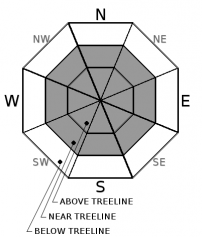
Avalanche Problem 1: Wind Slab
-
Character ?

-
Aspect/Elevation ?
-
Likelihood ?CertainVery LikelyLikelyPossible
 Unlikely
 -
Size ?HistoricVery LargeLargeSmall

With 3-6 inches of new snow over the last 24 hours and light to moderate wind, fresh wind slabs will be a concern on steep slopes today. These new wind slabs will remain small in isolated terrain but could potential grow as light winds out of the south and east continue to blow.
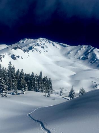
Small, isolated wind slabs up to 4 inches thick were observed primarily on SW-W-NW-N-NE-E aspects, near and above treeline yesterday. Variable mountain winds and cross loading could allow fresh wind slabs to be found on any steep slope near and above treeline today.
Continued caution and paying attention to where leeward areas reside will be necessary if venturing out into steep terrain. Look for signs of wind slabs and cornices as you travel in safe terrain. Stay away from areas where shooting cracks, blocking, and whumphing are observed. Other signs of wind slabs include previously drifted snow and chalky, hollow sounding snow.
If wind slabs are encountered keep travel to lower angle, windward slopes to return to safety. Identify features of concern. Travel one at a time in steep leeward terrain. Choose appropriate safety zones. Basic avalanche rescue skills are always necessary when you travel in avalanche terrain.
Forecast Discussion
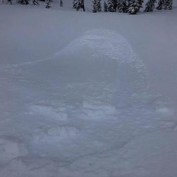
Human triggered slabs are possible in avalanche terrain. Small windslabs were seen reactive on Green Butte and in the Eddies yesterday. These likely remain reactive and small in isolated terrain but could grow in size throughout the day. Be careful.
Recent Observations
In the last 24 hours:
- Temperatures have ranged from 17 to 21 degrees F at treeline on Mount Shasta.
- Wind: 7 mi/hr average, with gusts to 25 out of the W/NW
- Precip: +/- 6 inches of new snow (.92 inches of SWE)
- A number of small wind slab and sluff avalanches were easily triggered on a west aspect of Green Butte ridge towards Avalanche Gulch.
- Similar small windslab formation and easy triggering were seen in the Eddies.
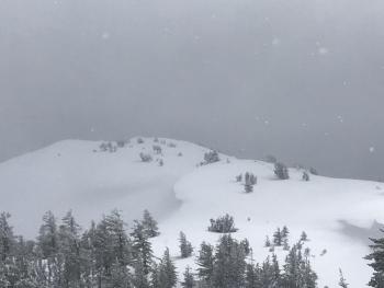
- Low visibility and blowing snow above treeline on Mount Shasta.
- New snow sit on top of a supportable crust above a previously upside down storm snow layering observed: moist, heavy snow on top, dryer snow below.
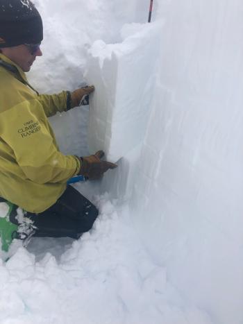
- Stability tests show instabilities are confined to the new snow old snow interface on Mount Shasta.
- We had one outlier extended column test submitted Friday by the public that failed and fully propagated upon isolation on a 30 degree, northeast aspect of Ash Creek Butte. (NE @ 7,900' - ECTP0x2 - SC/Q1). The test failed on an icy crust, 27 inches down from the surface. The group decided to turn back and noted several old crown lines in the area as well. We are uncertain if this unstable result is an isolated anomaly or if a persistent weak layer problem exists out there. We will investigate further today.
Weather and Current Conditions
Weather Summary
Light snow showers will linger this morning with low snow levels. Most of the power and moisture of this little storm has been released yesterday and last night. Expect clearing skies and increasing temperatures throughout the day. The heart (area of low pressure) of this storm is moving out to the east of the forecast area. This will allow light to moderate wind out of the south and east to blow today. Things should begin to dry out and clear up by this afternoon allowing for clear skies and sunny conditions tomorrow.
The next front approaches on tomorrow night into early Tuesday morning. There is little moisture associated with this next front so expect little accumulation in terms of snow.
24 Hour Weather Station Data @ 6:00 AM
| Weather Station | Temp (°F) | Wind (mi/hr) | Snow (in) | Comments | ||||||||
|---|---|---|---|---|---|---|---|---|---|---|---|---|
| Cur | Min | Max | Avg | Avg | Max Gust | Dir | Depth | New | Water Equivalent | Settlement | ||
| Mt. Shasta City (3540 ft) | 30 | 29 | 43 | 35 | 2 | N | ||||||
| Sand Flat (6750 ft) | 22 | 18 | 27 | 22 | 152 | 6 | 0 | 2 | ||||
| Ski Bowl (7600 ft) | 18 | 13 | 21.5 | 17.5 | 188 | 5 | 0.92 | 0.5 | ||||
| Gray Butte (8000 ft) | 17 | 12.5 | 23 | 17 | 7 | 25 | SSW | |||||
| Castle Lake (5870 ft) | 24 | 19.5 | 27.5 | 23.5 | 150 | 7 | 0.5 | |||||
| Mount Eddy (6509 ft) | 21.5 | 16 | 26.5 | 21 | 1 | 8 | S | 143 | 4 | 0 | ||
| Ash Creek Bowl (7250 ft) | ||||||||||||
| Ash Creek Ridge (7895 ft) |
Two Day Mountain Weather Forecast
Produced in partnership with the Medford NWS
| For 7000 ft to 9000 ft | |||
|---|---|---|---|
|
Sunday (4 a.m. to 10 p.m.) |
Sunday Night (10 p.m. to 4 a.m.) |
Monday (4 a.m. to 10 p.m.) |
|
| Weather | Snow showers possible. Chance of snow 50%. Snow levels 2k to 3k feet. | Becoming mostly clear | Sunny |
| Temperature (°F) | 33 | 19 | 41 |
| Wind (mi/hr) | East 5-10 | Northeast 5-10 | Northeast 5-10 |
| Precipitation SWE / Snowfall (in) | / 0-2 | / 0 | / 0 |
| For 9000 ft to 11000 ft | |||
| Sunday | Sunday Night | Monday | |
| Weather | Snow showers possible. Chance of snow 50%. | Clear | Sunny |
| Temperature (°F) | 11 | 11 | 14 |
| Wind (mi/hr) | South 5-10 | East 0-2 | East 10-15 |
| Precipitation SWE / Snowfall (in) | / 0-2 | / 0 | / 0 |
Season Precipitation for Mount Shasta City
| Period | Measured (in) | Normal (in) | Percent of Normal (%) |
|---|---|---|---|
| From Oct 1, 2025 (the wet season) | 31.68 | 31.69 | 100 |
| Month to Date (since Jul 1, 2026) | 2.15 | 2.19 | 98 |
| Year to Date (since Jan 1, 2026) | 23.27 | 16.48 | 141 |

