

You are here
Avalanche Forecast for 2019-04-07 06:50
- EXPIRED ON April 8, 2019 @ 6:50 amPublished on April 7, 2019 @ 6:50 am
- Issued by Ryan Sorenson - Mount Shasta Avalanche Center
Bottom Line
An atmospheric river event is currently impacting the Mount Shasta area. Expect rising temperatures and snow levels with heavy rain/snow over the next 24 hours. Breezy and wet weather will continue. Considerable avalanche danger exists due to loose-wet, wind slab, and cornice fall avalanche problems.


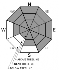
Avalanche Problem 1: Loose Wet
-
Character ?

-
Aspect/Elevation ?
-
Likelihood ?CertainVery LikelyLikelyPossible
 Unlikely
 -
Size ?HistoricVery LargeLargeSmall

Further saturating layers of the questionable snowpack structure could cause large avalanches today. Loose-wet avalanche danger continues to increase in size and likelihood due to rising temperatures and continued rain and snow. Snow levels could rise as high as 8,600 feet on Mount Shasta in the next 24 hours. Loose-wet slides often start at a single point and fan out as they move downhill. Additional snow is entrained as these avalanches gain speed and mass. Slopes with a long fetch can allow for large and destructive loose-wet avalanches.
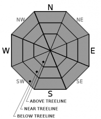
Avalanche Problem 2: Wind Slab
-
Character ?

-
Aspect/Elevation ?
-
Likelihood ?CertainVery LikelyLikelyPossible
Unlikely
-
Size ?HistoricVery LargeLargeSmall
Fresh wind slab avalanches are possible today. With wind slabs, pay attention to which way the wind is blowing. Expect strong south and west winds today. Wind slabs could grow large above treeline, especially on N-NE-E-SE leeward aspects. Wind impacts on the snow have been minimal due to the moist nature of this storm. However, immediate warming or rain could cause fresh wind slabs to cut loose. Large windslabs are likely in steep leeward terrain.
Avalanche Problem 3: Cornice
-
Character ?

-
Aspect/Elevation ?
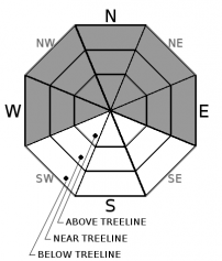
Any remaining cornices will likely be brought to their breaking point today as wet and warming weather continues to add weight. Failing cornices may have the ability to trigger loose-wet avalanches or slabs.
Forecast Discussion
It's wet and wild out there. Avalanche danger could rise quickly with rain on snow near and above treeline today and tonight. Large natural avalanches are possible and human triggered avalanches are likely in steep terrain.
Recent Observations
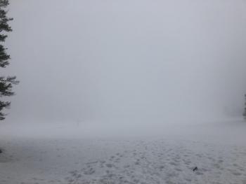
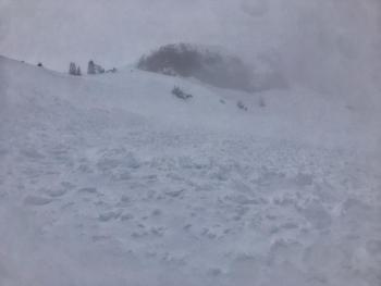
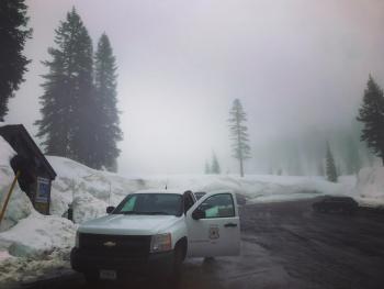
Yesterday rain was observed on Mount Shasta as high as 8,000 feet. Rain and snow showers would move in and out; it would rain one minute then snow the next as clouds and sun holes moved overhead. Light to moderate southwest wind was observed above treeline. Calm foggy conditions existed below and near treeline. Small wind slabs were reactive on the east facing ridgeline of Green Butte. A complex questionable snowpack with many wet and dry mixed layers was observed in a snow pit at 8,000 feet on Mount Shasta. Column test point toward instabilities failing 6 to 12 inches (20-30 cm) down. Low visibility limited observations above treeline. No recent avalanches were observed.
Weather and Current Conditions
Weather Summary
Wet weather will continue with rising temperatures, rain and breezy conditions for the Mount Shasta area. Two to three inches of water will continue to fall as snow or rain by tomorrow night. Snow levels could rise as high as 8,600 feet tonight. A flood watch is in effect from 11 am this morning through tomorrow afternoon. Wet weather will continue throughout the week.
24 Hour Weather Station Data @ 6:00 AM
| Weather Station | Temp (°F) | Wind (mi/hr) | Snow (in) | Comments | ||||||||
|---|---|---|---|---|---|---|---|---|---|---|---|---|
| Cur | Min | Max | Avg | Avg | Max Gust | Dir | Depth | New | Water Equivalent | Settlement | ||
| Mt. Shasta City (3540 ft) | 47 | 37.5 | 47 | 45 | 5 | ESE | ||||||
| Sand Flat (6750 ft) | 35 | 28 | 35 | 33 | 140 | 2 | 0 | 3 | ||||
| Ski Bowl (7600 ft) | 33 | 24.5 | 33.5 | 30.5 | 189.7 | 2.6 | 1.25 | 1 | ||||
| Gray Butte (8000 ft) | 32 | 23.5 | 33.5 | 30.5 | 14 | 31 | WSW | |||||
| Castle Lake (5870 ft) | 31 | 29.5 | 31 | 30 | 136.5 | 0.5 | .5 | |||||
| Mount Eddy (6509 ft) | 35.5 | 28 | 37 | 34.5 | 2 | 14 | SSE | 133.9 | 1 | 5 | ||
| Ash Creek Bowl (7250 ft) | ||||||||||||
| Ash Creek Ridge (7895 ft) |
Two Day Mountain Weather Forecast
Produced in partnership with the Medford NWS
| For 7000 ft to 9000 ft | |||
|---|---|---|---|
|
Sunday (4 a.m. to 10 p.m.) |
Sunday Night (10 p.m. to 4 a.m.) |
Monday (4 a.m. to 10 p.m.) |
|
| Weather | Rain, windy. Snow levels near 7,800 feet. | Rain, windy, Snow levels near 8,600. | Rain. Snow levels near 8,600 feet. |
| Temperature (°F) | 40 | 38 | 40 |
| Wind (mi/hr) | South 15-20 | South 15-20 | South 10-15 |
| Precipitation SWE / Snowfall (in) | 0.16 / 0-2 | 0.21 / 0-2 | 0.62 / 0-4 |
| For 9000 ft to 11000 ft | |||
| Sunday | Sunday Night | Monday | |
| Weather | Snow, heavy at times, windy, temperatures rising. | Snow, heavy at times, windy. | Snow/rain, heavy at times, windy, temperatures rising. |
| Temperature (°F) | 30 | 28 | 30 |
| Wind (mi/hr) | West 35-40 | West 2-4 | Southwest 40-50 |
| Precipitation SWE / Snowfall (in) | 0.16 / 2-4 | 0.21 / 2-4 | 0.62 / 2-6 |
Season Precipitation for Mount Shasta City
| Period | Measured (in) | Normal (in) | Percent of Normal (%) |
|---|---|---|---|
| From Oct 1, 2025 (the wet season) | 37.68 | 36.16 | 104 |
| Month to Date (since Jul 1, 2026) | 2.46 | 0.70 | 351 |
| Year to Date (since Jan 1, 2026) | 29.27 | 20.95 | 140 |

