

You are here
Avalanche Forecast for 2019-04-08 06:30
- EXPIRED ON April 9, 2019 @ 6:30 amPublished on April 8, 2019 @ 6:30 am
- Issued by Ryan Sorenson - Mount Shasta Avalanche Center
Bottom Line
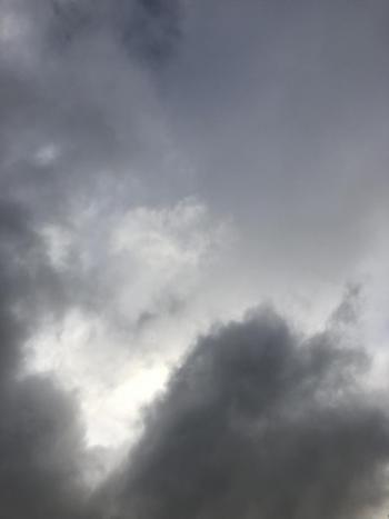
Excessive rainfall has saturated the snowpack below and near treeline on Mount Shasta. There is some uncertainty about the existing snowpack. Odds are many instabilities have settled out, although any remaining instability could be of consequential size. Considerable avalanche danger remains due to wind slab, loose-wet, and cornice fall avalanche problems. Breezy and wet weather will continue today.


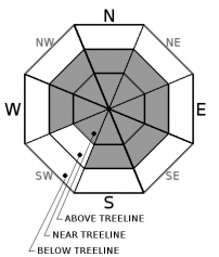
Avalanche Problem 1: Wind Slab
-
Character ?

-
Aspect/Elevation ?
-
Likelihood ?CertainVery LikelyLikelyPossible
 Unlikely
 -
Size ?HistoricVery LargeLargeSmall

Wind slab avalanches are possible today. Further warming and more rain could cause remaining wind slabs to cut loose. With wind slabs, pay attention to which way the wind is blowing. Expect strong south and west winds today. Wind slabs could grow large, especially on N-NE-E-SE leeward aspects above treeline. Recent wind impacts on the snow have been minimal due to the moist nature of this storm. However, strong winds and continued moisture could form large, fresh wind slabs in isolated steep leeward terrain at higher altitudes on Mount Shasta.
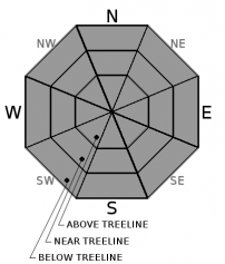
Avalanche Problem 2: Loose Wet
-
Character ?

-
Aspect/Elevation ?
-
Likelihood ?CertainVery LikelyLikelyPossible
Unlikely
-
Size ?HistoricVery LargeLargeSmall
Continued saturating of layers within the snowpack structure could cause large avalanches today. Loose-wet avalanche danger continues to increase in size and likelihood due to rising temperatures and continued rain on snow. Snow levels could rise as high as 8,600 feet on Mount Shasta today.
Wet loose snow slides consist of dense, heavy, wet snow and can sometimes grow to large and destructive sizes. Loose-wet slides often start at a single point and fan out as they move downhill. Slopes with a long fetch can allow for large and destructive loose-wet avalanches.
Avalanche Problem 3: Cornice
-
Character ?

-
Aspect/Elevation ?
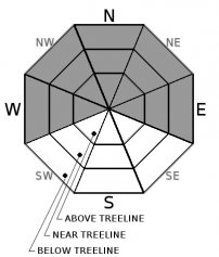
Any remaining cornices will likely be brought to their breaking point today as wet and warming weather continues to add weight. Don't be above or below them. Failing cornices may have the ability to trigger loose-wet avalanches or slabs.
Forecast Discussion
A flood watch remains in effect until 11 pm this evening. Large amounts of runoff due to excessive rainfall and saturated soils could allow some smaller creeks and streams to overflow their banks.
Recent Observations
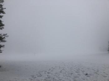
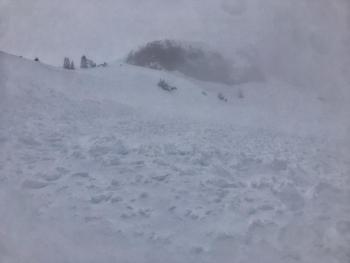
Its been a moist couple days in the mountains. Observations have been limited due to nasty, rain on snow conditions and very poor visibility below, near and above treeline. A saturated snowpack was observed at Castle Lake yesterday (04.07.2019). Foggy, rainy conditions kept visibility to less than 1/8 mile. Rain has allowed the snowpack to settle significantly. Snow surfaces hosted punchy moist to wet snow atop soft saturated wet slush. This allowed for a boot penetration of one to two feet deep. Trees have shredded any remaining snow from their branches and large settlement cones have formed around the trunks. No recent avalanches or instabilities were observed.
In the last 24 hours:
- Temperatures have ranged from 32.5 to 38 degrees F at treeline on Mount Shasta.
- Wind: 18 mi/hr average, with gusts to 31 out of the W/SW
- Precip: 1.17 inches of rain and 6 inches of snow settlement at Old Ski Bowl

Weather and Current Conditions
Weather Summary
The wet spring storm currently impacting the Mount Shasta area will drop a remaining inch to two inches of water over the next 24 hours as temperatures and snow levels continue to rise. Expect snow levels as high as 8,600 feet today. Breezy wind with strong gusts will continue to blow from the southwest.
This storm may go out with a bang as thunder and lightning is possible after 11 p.m. this evening. Temperatures and snow levels will drop to near 6,600 feet after as lingering light snow showers will leave a dusting of snow by tomorrow morning. Lingering snow showers will stick around tomorrow with little accumulation possible. Dry and windy conditions are expected for Wednesday.
24 Hour Weather Station Data @ 6:00 AM
| Weather Station | Temp (°F) | Wind (mi/hr) | Snow (in) | Comments | ||||||||
|---|---|---|---|---|---|---|---|---|---|---|---|---|
| Cur | Min | Max | Avg | Avg | Max Gust | Dir | Depth | New | Water Equivalent | Settlement | ||
| Mt. Shasta City (3540 ft) | 50 | 47 | 52 | 50 | 5 | ESE | ||||||
| Sand Flat (6750 ft) | 38 | 33 | 39 | 37 | 135 | 0 | 5 | |||||
| Ski Bowl (7600 ft) | 37 | 32.5 | 38 | 36 | 183.1 | 0 | 1.17 | 6.3 | ||||
| Gray Butte (8000 ft) | 36 | 32 | 37 | 35 | 18 | 31 | WSW | |||||
| Castle Lake (5870 ft) | ||||||||||||
| Mount Eddy (6509 ft) | 39 | 36.5 | 45 | 40 | 2 | 15 | SSE | 132 | 0 | 5 | ||
| Ash Creek Bowl (7250 ft) | ||||||||||||
| Ash Creek Ridge (7895 ft) |
Two Day Mountain Weather Forecast
Produced in partnership with the Medford NWS
| For 7000 ft to 9000 ft | |||
|---|---|---|---|
|
Monday (4 a.m. to 10 p.m.) |
Monday Night (10 p.m. to 4 a.m.) |
Tuesday (4 a.m. to 10 p.m.) |
|
| Weather | Rain, windy. Snow levels near 8,600 feet. | Rain or snow, windy, Snow levels dropping to near 6,600 feet. | Snow showers possible. Snow level near 4,300 feet. |
| Temperature (°F) | 40 | 31 | 35 |
| Wind (mi/hr) | South 20-30 | West 15-20 | Northwest 15-20 |
| Precipitation SWE / Snowfall (in) | 0.67 / 0-2 | 0.30 / 0-3 | 0.20 / 0-2 |
| For 9000 ft to 11000 ft | |||
| Monday | Monday Night | Tuesday | |
| Weather | Snow, heavy at times, windy, temperatures rising. | Lingering snow showers, heavy snow at times. | Breezy, snow showers possible |
| Temperature (°F) | 30 | 15 | 20 |
| Wind (mi/hr) | South 25-30 | West 20-25 | Northwest 35-40 |
| Precipitation SWE / Snowfall (in) | 0.67 / 4-6 | 0.30 / 1-3 | 0.20 / 0-3 |
Season Precipitation for Mount Shasta City
| Period | Measured (in) | Normal (in) | Percent of Normal (%) |
|---|---|---|---|
| From Oct 1, 2025 (the wet season) | 37.92 | 36.27 | 105 |
| Month to Date (since Jun 1, 2026) | 2.70 | 0.81 | 333 |
| Year to Date (since Jan 1, 2026) | 29.51 | 21.06 | 140 |

