

You are here
Avalanche Forecast for 2019-04-09 07:00
- EXPIRED ON April 10, 2019 @ 7:00 amPublished on April 9, 2019 @ 7:00 am
- Issued by Aaron Beverly - Mount Shasta Avalanche Center
Bottom Line
Evaluate the snowpack for wind slabs as you transition to above treeline elevations. They could be large and capable of human triggering. Dropping temperatures have diminished the concern for wet loose avalanches and cornice breaks.


Avalanche Problem 1: Wind Slab
-
Character ?

-
Aspect/Elevation ?
-
Likelihood ?CertainVery LikelyLikelyPossible
 Unlikely
 -
Size ?HistoricVery LargeLargeSmall

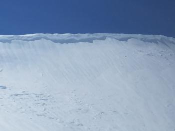
Whiteout conditions have prevented any useful observations above treeline, but large wind slabs could exist. In the last 3 days, close to 4 inches of rain has fallen at 7,600 feet. Elevations above 9,000 feet may have over two feet of recent snow. SW/W/NW winds have been productive.
Pay attention as you transition to elevations that have not been affected by above freezing temperatures. Shooting cracks or blocking snow in wind drifted areas are signs of the wind slab problem. It'll be best to avoid steep leeward slopes today.
Forecast Discussion
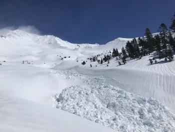
Concern for wet avalanches and cornice breaks have diminished as falling temperatures are likely hardening wet snow surfaces. Firm conditions will begin to be encountered below and near treeline. Nonetheless, today is a day of transition. If you are post-holing above the cuff of your boot in wet snow near very steep aspects, you may want to move to lower angle terrain.
Recent Observations
Whiteout conditions near and above treeline limited observations yesterday afternoon on Mount Shasta. Light to moderate rain was encountered up to 8,200 ft. The upper 18 inches of the snow pack was very wet, though it did not feel capable of sluffing. Column tests did not yield notable results.
1.33 inches of rain fell near treeline in the last 24 hours. Temperatures dropped below freezing after 10 p.m. West/southwest and northwest winds have averaged 22 mi/hr gusting up to 61.

Weather and Current Conditions
Weather Summary
High pressure ridging will bring an end to precipitation by 11 a.m. In the next 24 hours, snow levels will drop to 3,500 ft and northerly winds will be moderate to strong. Optimistic predictions put snow accumulation at up to 2 inches above treeline.
More systems are lined up to bring wet conditions Thursday and Saturday. An unsettled weather pattern will continue into next week.
24 Hour Weather Station Data @ 5:00 AM
| Weather Station | Temp (°F) | Wind (mi/hr) | Snow (in) | Comments | ||||||||
|---|---|---|---|---|---|---|---|---|---|---|---|---|
| Cur | Min | Max | Avg | Avg | Max Gust | Dir | Depth | New | Water Equivalent | Settlement | ||
| Mt. Shasta City (3540 ft) | 38 | 38 | 54 | 47.5 | 3 | |||||||
| Sand Flat (6750 ft) | 25 | 25 | 40 | 35 | 134 | 0 | 0 | 1 | ||||
| Ski Bowl (7600 ft) | 22.5 | 22.5 | 38 | 32.5 | 177.1 | 0.2 | 1.18 | 6 | ||||
| Gray Butte (8000 ft) | 20.5 | 20.5 | 36.5 | 30.5 | 21 | 61 | WSW | |||||
| Castle Lake (5870 ft) | ||||||||||||
| Mount Eddy (6509 ft) | 25 | 24.5 | 42.5 | 34 | 2 | 13 | S | 128.8 | 0 | 1 | ||
| Ash Creek Bowl (7250 ft) | ||||||||||||
| Ash Creek Ridge (7895 ft) |
Two Day Mountain Weather Forecast
Produced in partnership with the Medford NWS
| For 7000 ft to 9000 ft | |||
|---|---|---|---|
|
Tuesday (4 a.m. to 10 p.m.) |
Tuesday Night (10 p.m. to 4 a.m.) |
Wednesday (4 a.m. to 10 p.m.) |
|
| Weather | A 40 percent chance of snow showers, mainly before 11 a.m. Mostly sunny. | Partly cloudy. Breezy. | Mostly sunny. Breezy. |
| Temperature (°F) | 33 | 25 | 39 |
| Wind (mi/hr) | Northwest 10-15 | Northwest 15-20 | Northwest 10-15 |
| Precipitation SWE / Snowfall (in) | 0.04 / 0-0.50 | 0.00 / 0 | 0.00 / 0 |
| For 9000 ft to 11000 ft | |||
| Tuesday | Tuesday Night | Wednesday | |
| Weather | A 50 percent chance of snow showers. Partly sunny. Windy, gusty, low wind chills. | Partly cloudy. Windy, gusty, low wind chills. | Mostly sunny. Windy, gusty, low wind chills. |
| Temperature (°F) | 17 | 17 | 24 |
| Wind (mi/hr) | Northwest 35-40 | North 35-45 | North 30-35 |
| Precipitation SWE / Snowfall (in) | 0.04 / 0.50-2 | 0.00 / 0 | 0.00 / 0 |
Season Precipitation for Mount Shasta City
| Period | Measured (in) | Normal (in) | Percent of Normal (%) |
|---|---|---|---|
| From Oct 1, 2025 (the wet season) | 38.38 | 36.37 | 106 |
| Month to Date (since Jun 1, 2026) | 3.16 | 0.91 | 347 |
| Year to Date (since Jan 1, 2026) | 29.97 | 21.16 | 142 |

