

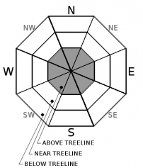
You are here
Avalanche Forecast for 2019-04-10 06:00
- EXPIRED ON April 11, 2019 @ 6:00 amPublished on April 10, 2019 @ 6:00 am
- Issued by Aaron Beverly - Mount Shasta Avalanche Center
Bottom Line
Some concern for wind slabs remains above treeline where snow and wind continue to intermingle. Evaluate the snow and terrain carefully as you transition high into the alpine. Be prepared for firm snow surfaces near and below treeline.


Avalanche Problem 1: Wind Slab
-
Character ?

-
Aspect/Elevation ?
-
Likelihood ?CertainVery LikelyLikelyPossible
 Unlikely
 -
Size ?HistoricVery LargeLargeSmall

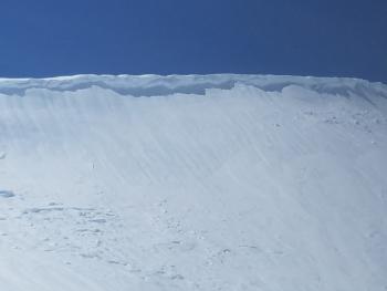
Uncertainty in conditions exists above treeline where plenty of snow and wind continue to intermingle. Wind slabs may exist on leeward aspects. These could be several feet thick.
Pay attention as you transition to elevations that were not affected by above freezing temperatures. Shooting cracks or blocking snow in wind drifted areas and scoured aspects are signs that a wind slab problem exists nearby. Evaluate the snowpack carefully before exposing yourself to steep leeward slopes.
Forecast Discussion
The snowpack near and below treeline has become locked up tight by freezing temperatures. Be prepared for firm, icy surfaces.
Recent Observations
Temperatures remained well below freezing for much of the last 24 hours and wet snow surfaces that existed below and near treeline have become firm. Northerly winds were cranking and transporting snow above treeline yesterday afternoon and evening. West aspects above treeline were becoming scoured.
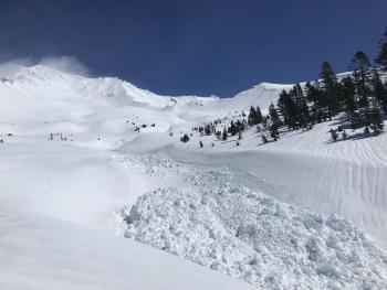
The remains of a large (R3/D3) wet avalanche was seen in Avalanche Gulch yesterday. Best estimates put its occurrence is late Sunday, April 7th. Check out yesterday's observation for details.

Weather and Current Conditions
Weather Summary
Some weak frontal systems may graze our forecast area over the next several days, but generally things look to be clear into next week. Tomorrow will bring a slight chance of snow above 5,300 feet but no accumulation is expected.
The climate prediction center indicates above average precipitation over the next month.
Get a nice synopsis of our winter from the California Weather Blog.
24 Hour Weather Station Data @ 4:00 AM
| Weather Station | Temp (°F) | Wind (mi/hr) | Snow (in) | Comments | ||||||||
|---|---|---|---|---|---|---|---|---|---|---|---|---|
| Cur | Min | Max | Avg | Avg | Max Gust | Dir | Depth | New | Water Equivalent | Settlement | ||
| Mt. Shasta City (3540 ft) | 38 | 38 | 54 | 47.5 | 3 | |||||||
| Sand Flat (6750 ft) | 31 | 25 | 34 | 29 | 133 | 0 | 0 | 1 | ||||
| Ski Bowl (7600 ft) | 35 | 22.5 | 35 | 28.5 | 175.7 | 0 | 0.07 | 1.5 | ||||
| Gray Butte (8000 ft) | 23 | 20.5 | 30.5 | 25.5 | 21 | 61 | N | |||||
| Castle Lake (5870 ft) | ||||||||||||
| Mount Eddy (6509 ft) | 21.5 | 21.5 | 30.5 | 26 | 3 | 18 | SSE | 126 | 0 | 0 | ||
| Ash Creek Bowl (7250 ft) | ||||||||||||
| Ash Creek Ridge (7895 ft) |
Two Day Mountain Weather Forecast
Produced in partnership with the Medford NWS
| For 7000 ft to 9000 ft | |||
|---|---|---|---|
|
Wednesday (4 a.m. to 10 p.m.) |
Wednesday Night (10 p.m. to 4 a.m.) |
Thursday (4 a.m. to 10 p.m.) |
|
| Weather | Sunny. Breezy. | Mostly cloudy. Blustery. | A 40 percent chance of snow showers. Mostly cloudy. Breezy. |
| Temperature (°F) | 39 | 27 | 37 |
| Wind (mi/hr) | Northwest 10-15 | Northwest 10-15 | Northwest 10-15 |
| Precipitation SWE / Snowfall (in) | 9.00 / 0 | 0.00 / 0 | 0.02 / 0-0.25 |
| For 9000 ft to 11000 ft | |||
| Wednesday | Wednesday Night | Thursday | |
| Weather | Sunny. Windy, gusty, low wind chills. | A 20 percent chance of snow showers after 11 p.m. Mostly cloudy. Windy, gusty, low wind chills. | A 40 percent chance of snow showers. Mostly cloudy. Windy, gusty, low wind chills. |
| Temperature (°F) | 25 | 15 | 19 |
| Wind (mi/hr) | North 40-45 | Northwest 35-40 | Northwest 35-40 |
| Precipitation SWE / Snowfall (in) | 9.00 / 0 | 0.00 / 0 | 0.02 / 0-0.25 |
Season Precipitation for Mount Shasta City
| Period | Measured (in) | Normal (in) | Percent of Normal (%) |
|---|---|---|---|
| From Oct 1, 2025 (the wet season) | 38.38 | 36.47 | 105 |
| Month to Date (since Jun 1, 2026) | 3.16 | 1.01 | 313 |
| Year to Date (since Jan 1, 2026) | 29.97 | 21.26 | 141 |

