

You are here
Avalanche Forecast for 2019-04-12 05:30
- EXPIRED ON April 13, 2019 @ 5:30 amPublished on April 12, 2019 @ 5:30 am
- Issued by Aaron Beverly - Mount Shasta Avalanche Center
Bottom Line
Avalanche danger is low at all elevations. Exercise normal caution in the backcountry. Be prepared for gale force winds above treeline. Firm, scoured, snow surfaces are widespread. Climbers will want an ice axe, crampons, and a helmet. Self-arrest will be difficult.


Avalanche Problem 1: Normal Caution
-
Character ?

Exercise normal caution:
- Make a plan.
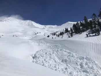
- Watch for isolated wind slabs above treeline.
- Travel through avalanche terrain one at a time.
- Have the tools and skills necessary for basic avalanche rescue.
If you run into chalky, cracking snow, be aware that wind slabs may be nearby on steep leeward slopes.
Forecast Discussion
Clear weather will tempt climbers and skiers into the alpine regions this weekend. Snow surfaces are firm, scoured, and smooth. Bring an ice axe, crampons, and a helmet. Remember that even with an ice axe, self-arrest will be very difficult.
Recent Observations
The snowpack remained mostly unchanged in the last 24 hours, with temperatures only briefly reaching above freezing at 7,600 ft. Winds have been mostly light.
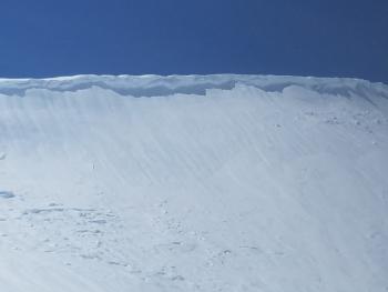
Snow surfaces are firm and scoured near and above treeline.
No recent signs of instability have been observed.

Weather and Current Conditions
Weather Summary
Solar radiation and above freezing temperatures may loosen up firm snow surfaces near and above treeline today. But hold onto your hats as northerly winds could reach gale force speeds.
A near perfect day is on order tomorrow with diminishing winds, sun, and temperatures in the low 50s near treeline.
Another front moves in late Sunday as part of a pattern indicating a moderate atmospheric river event, though the amount of precipitation expected does not seem worthy of the moniker. More on this to come.
24 Hour Weather Station Data @ 4:00 AM
| Weather Station | Temp (°F) | Wind (mi/hr) | Snow (in) | Comments | ||||||||
|---|---|---|---|---|---|---|---|---|---|---|---|---|
| Cur | Min | Max | Avg | Avg | Max Gust | Dir | Depth | New | Water Equivalent | Settlement | ||
| Mt. Shasta City (3540 ft) | 38 | 38 | 51 | 47.5 | 3 | |||||||
| Sand Flat (6750 ft) | 27 | 27 | 35 | 31 | 130 | 0 | 0 | 1 | ||||
| Ski Bowl (7600 ft) | 25 | 24 | 35 | 28 | 173.7 | 0.1 | 0.07 | 0.2 | ||||
| Gray Butte (8000 ft) | 23 | 23 | 28 | 26 | 6 | 37 | ESE | |||||
| Castle Lake (5870 ft) | ||||||||||||
| Mount Eddy (6509 ft) | 27 | 26.5 | 32 | 28.5 | 3 | 12 | SE | 126.4 | 0 | 0 | ||
| Ash Creek Bowl (7250 ft) | ||||||||||||
| Ash Creek Ridge (7895 ft) |
Two Day Mountain Weather Forecast
Produced in partnership with the Medford NWS
| For 7000 ft to 9000 ft | |||
|---|---|---|---|
|
Friday (4 a.m. to 10 p.m.) |
Friday Night (10 p.m. to 4 a.m.) |
Saturday (4 a.m. to 10 p.m.) |
|
| Weather | Mostly sunny. Breezy. | Mostly clear. | Mostly sunny. |
| Temperature (°F) | 43 | 27 | 51 |
| Wind (mi/hr) | Northwest 10-15 | North 5-10 | North 5-10 |
| Precipitation SWE / Snowfall (in) | 0.00 / 0 | 0.00 / 0 | 0.00 / 0 |
| For 9000 ft to 11000 ft | |||
| Friday | Friday Night | Saturday | |
| Weather | Mostly sunny. Gale force winds possible. Low wind chills. | Mostly clear. Windy and gusty. | Mostly sunny. |
| Temperature (°F) | 31 | 31 | 33 |
| Wind (mi/hr) | North 35-45 | North 30-35 | Northwest 20-25 |
| Precipitation SWE / Snowfall (in) | 0.00 / 0 | 0.00 / 0 | 0.00 / 0 |
Season Precipitation for Mount Shasta City
| Period | Measured (in) | Normal (in) | Percent of Normal (%) |
|---|---|---|---|
| From Oct 1, 2025 (the wet season) | 38.39 | 36.68 | 105 |
| Month to Date (since Jun 1, 2026) | 3.17 | 1.22 | 260 |
| Year to Date (since Jan 1, 2026) | 29.98 | 21.47 | 140 |

