

You are here
Avalanche Forecast for 2019-12-11 06:00
- EXPIRED ON December 12, 2019 @ 6:00 amPublished on December 11, 2019 @ 6:00 am
- Issued by Aaron Beverly - Mount Shasta Avalanche Center
Bottom Line
Avalanche danger could rise to MODERATE late tonight as new snow combines with strong westerly winds to form wind slabs. High snow levels will limit this problem to elevations above treeline.


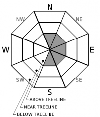
Avalanche Problem 1: Wind Slab
-
Character ?

-
Aspect/Elevation ?
-
Likelihood ?CertainVery LikelyLikelyPossible
 Unlikely
 -
Size ?HistoricVery LargeLargeSmall

Up to 4 inches of snow may fall by early tomorrow morning. With productive westerly winds, wind slabs may begin to form above treeline late tonight.
In the unlikely event you are traveling above treeline in the wee hours of the morning, look for drifting snow, cracking, and blocking as indications of a wind slab problem. These will probably be on easterly aspects. Scoured areas along ridge tops could mean snow is piling up in lee areas nearby.
Smooth, crusty surfaces encountered in start zones yesterday may provide ideal bed surfaces for these slabs to slide on. When in doubt, avoid slopes greater than 35 degrees.
Forecast Discussion
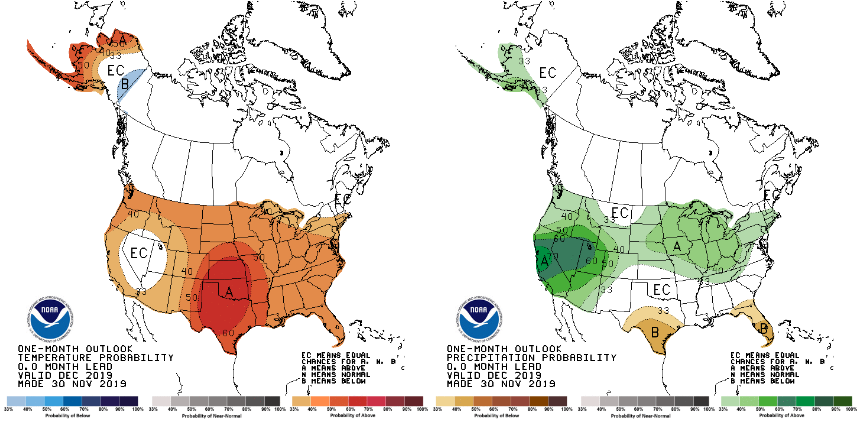
The one month outlook from the Climate Predication Center is indicating above normal precipitation, but above normal temperatures.
Recent Observations
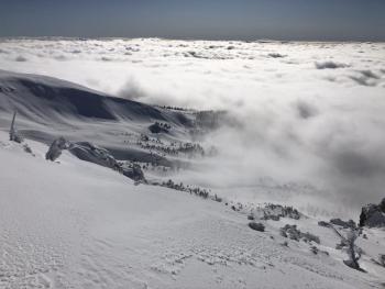
In the last 24 hours at the Old Ski Bowl, temperatures have ranged from 24 to 39°F. Warmer temperatures did not seem to be affecting the snowpack. Cloudy weather and winds were keeping things cold. Although Gray Butte reports mostly light winds under 15 mph, above treeline ridge tops saw strong westerly winds close to 30 mph. Some snow was being transported above treeline, but no wind slab concerns were encountered.
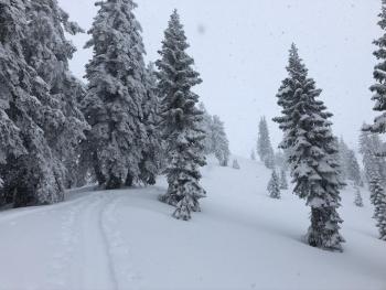
Near and above treeline, snow surfaces were generally smooth but variable - soft, thin wind crusts, breakable sun crusts, and wind affected chalk. Start zones have smooth, crusty bed surfaces that will be of concern if new wind slabs form on top. Gullies seemed to host the best snow, but generally skiing was not pleasant. Snowmobilers will have the most fun, but there are hazards still lurking beneath the snow surface so deep carving is not recommended.
No signs of instability were encountered above treeline.
Weather and Current Conditions
Weather Summary
Warmer, wetter conditions will prevail over the next few days. Snow levels will start at 5,500 ft today and will rise to 7,000 ft tomorrow. Optimistically, as much as 4 inches of snow could fall at high elevations over the next 24 hours. Westerly winds will be strong enough to transport new snow.
A couple of more inches are possible tomorrow. Unstable weather will continue until Saturday night, but don't expect much precipitation overall.
24 Hour Weather Station Data @ 4:00 AM
| Weather Station | Temp (°F) | Wind (mi/hr) | Snow (in) | Comments | ||||||||
|---|---|---|---|---|---|---|---|---|---|---|---|---|
| Cur | Min | Max | Avg | Avg | Max Gust | Dir | Depth | New | Water Equivalent | Settlement | ||
| Mt. Shasta City (3540 ft) | 39 | 29 | 43 | 36 | 2 | N | ||||||
| Sand Flat (6750 ft) | 29 | 25 | 34 | 29 | 29 | 0 | 0 | 1 | ||||
| Ski Bowl (7600 ft) | 25.5 | 24.5 | 39 | 30.5 | 38.9 | 0 | .04 | 1 | ||||
| Gray Butte (8000 ft) | 24.5 | 23.5 | 39.5 | 29.5 | 10 | 25 | W | |||||
| Castle Lake (5870 ft) | down | |||||||||||
| Mount Eddy (6509 ft) | 29 | 27.5 | 41 | 31.5 | 2 | 13 | WSW | 27 | 0 | 1 | ||
| Ash Creek Bowl (7250 ft) | down | |||||||||||
| Ash Creek Ridge (7895 ft) | down |
Two Day Mountain Weather Forecast
Produced in partnership with the Medford NWS
| For 7000 ft to 9000 ft | |||
|---|---|---|---|
|
Wednesday (4 a.m. to 10 p.m.) |
Wednesday Night (10 p.m. to 4 a.m.) |
Thursday (4 a.m. to 10 p.m.) |
|
| Weather | A chance of snow showers before 10 a.m, then snow likely after 10 a.m. Cloudy. Chance of precipitation is 70%. | Snow before 10 p.m., then rain and snow. Breezy. Chance of precipitation is 90%. | Rain and snow. Windy and gusty. Chance of precipitation is 100%. |
| Temperature (°F) | 29 | 38 | 37 |
| Wind (mi/hr) | Southwest 20-25 | Southwest 10-15 | Southwest 5-10 |
| Precipitation SWE / Snowfall (in) | 0.09 / 0-1 | 0.31 / 0-2 | 0.33 / 0-2 |
| For 9000 ft to 11000 ft | |||
| Wednesday | Wednesday Night | Thursday | |
| Weather | A chance of snow showers before 10 a.m., then snow likely after 10 a.m. Cloudy, low wind chills, windy and gusty. Chance of precipitation is 70%. | Snow. Windy and gusty, low wind chills. Chance of precipitation is 100%. | Snow. Windy and gusty, low wind chills. Chance of precipitation is 100%. |
| Temperature (°F) | 26 | 24 | 28 |
| Wind (mi/hr) | West 35-40 | West 30-35 | West 40-50 |
| Precipitation SWE / Snowfall (in) | 0.09 / 0-1 | 0.31 / 1-3 | 0.33 / 1-2 |
Season Precipitation for Mount Shasta City
| Period | Measured (in) | Normal (in) | Percent of Normal (%) |
|---|---|---|---|
| From Oct 1, 2025 (the wet season) | 7.53 | 9.69 | 78 |
| Month to Date (since Jun 1, 2026) | 4.85 | 2.33 | 208 |
| Year to Date (since Jan 1, 2026) | 45.27 | 37.69 | 120 |

