

You are here
Avalanche Forecast for 2019-12-12 06:13
- EXPIRED ON December 13, 2019 @ 6:13 amPublished on December 12, 2019 @ 6:13 am
- Issued by Nick Meyers - Shasta-Trinity National Forest
Bottom Line
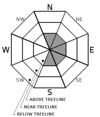
While not expected to pose a major concern, remain attentive to small, isolated wind slabs above treeline on S-SE-E-NE aspects from a few inches of fresh snow and strong W/SW wind. Expect MODERATE danger above treeline and generally LOW danger near and below treeline on Mount Shasta. Other areas within the forecast area still host shallow snowpack conditions.


Avalanche Problem 1: Wind Slab
-
Character ?

-
Aspect/Elevation ?
-
Likelihood ?CertainVery LikelyLikelyPossible
 Unlikely
 -
Size ?HistoricVery LargeLargeSmall

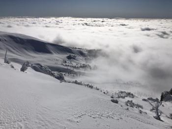
Small, isolated wind slabs may be encountered above treeline on Mount Shasta, primarily on easterly facing aspects. West/Southwest winds have been and will continue to be strong enough to transport freshly fallen snow. Wind slabs may not be large enough to bury a backcountry user, but could cause one to loose their balance and initiate a fall. Look for blowing snow, cornice formation and surface scouring as clues to where new wind slabs might exist.
Forecast Discussion
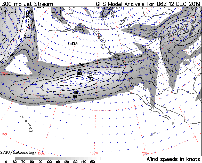
A nice looking jet stream delivering spurts of wet weather over the next couple days. Significant snow accumulation is not expected unfortunately, but something is better than nothing! West/Southwest wind and bits of new snow may contribute to small wind slab formation. Life threatening avalanche danger is not expected, though always use safe travel practices (one at a time in avalanche terrain; don't regroup in run out zones) and look for red flags of avalanche danger such as recent avalanches, wind blowing snow, cracking or collapsing in the snowpack.
Recent Observations
- In the last 24 hours at treeline on Mount Shasta, temperatures have ranged from 25 to 30°F with average wind speeds of 13 mi/hr, gusts to 25 mi/hr out of the west/southwest.
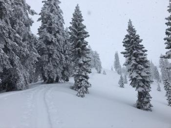
- Precipitation began at 1300 hours yesterday and persisted until midnight last night. Snow struggled to accumulate with only about 1 to 2 inches of new snow at 8,000 feet. Snow levels were near Sand/Bunny Flat area, 6,500 to 7,000 feet.
- Snow surfaces have been generally smooth albeit variable - soft, thin wind crusts, breakable sun crusts, and wind affected chalk. Start zones have smooth, crusty bed surfaces.
- Hazards still lurk beneath the snow surface.
- No red flags or other signs of instability have been encountered.
Weather and Current Conditions
Weather Summary
A northern hemispheric pattern shows a wave number of 4 to 5 around the globe, which usually indicates a progressive weather pattern. The jet stream is directly focused on Northern California and Southern Oregon. This will bring a continued series of quick moving systems onshore in rapid succession. The Cascades should see 1.5 to 3 inches of water all said and done. Snow levels will lie near 6,500 feet today, lowering to 5,500 feet tonight and tomorrow...thus a few inches of snow here and there over the course of the next couple days. Wind will be a factor in higher terrain. Gusty south/southwest winds up to 40 mi/hr can be expected this afternoon, especially in the Shasta Valley. Saturday will bring cooler air, though precipitation will diminish.
24 Hour Weather Station Data @ 4:00 AM
| Weather Station | Temp (°F) | Wind (mi/hr) | Snow (in) | Comments | ||||||||
|---|---|---|---|---|---|---|---|---|---|---|---|---|
| Cur | Min | Max | Avg | Avg | Max Gust | Dir | Depth | New | Water Equivalent | Settlement | ||
| Mt. Shasta City (3540 ft) | 39 | 29 | 43 | 36 | 2 | N | ||||||
| Sand Flat (6750 ft) | 33 | 29 | 33 | 31 | 30 | 1 | n/a | 0 | ||||
| Ski Bowl (7600 ft) | 30.5 | 25.5 | 30.5 | 27.5 | 40.6 | 1.7 | 0.34 | 1.3 | ||||
| Gray Butte (8000 ft) | 29 | 24.5 | 29.5 | 26.5 | 13 | 25 | W | |||||
| Castle Lake (5870 ft) | 0 | 0 | 0 | 0 | 0 | 0 | 0 | down | ||||
| Mount Eddy (6509 ft) | 34 | 28 | 34.5 | 31 | 2 | 12 | SSE | 27 | 1 | 0 | ||
| Ash Creek Bowl (7250 ft) | down | |||||||||||
| Ash Creek Ridge (7895 ft) | down |
Two Day Mountain Weather Forecast
Produced in partnership with the Medford NWS
| For 7000 ft to 9000 ft | |||
|---|---|---|---|
|
Thursday (4 a.m. to 10 p.m.) |
Thursday Night (10 p.m. to 4 a.m.) |
Friday (4 a.m. to 10 p.m.) |
|
| Weather | Rain and snow, breezy, chance of precipitation 90%. Snow levels near 6,500 feet. | Snow showers, chance of precipitation 90%. Snow levels near 6,500 feet, lowering to 5,500 feet. | Snow showers, breezy, chance of precipitation 100%. Snow levels near 5,500 feet. |
| Temperature (°F) | 36 | 29 | 33 |
| Wind (mi/hr) | Southwest 20-25 | Southwest 10-15 | Southwest 10-15 |
| Precipitation SWE / Snowfall (in) | 0.24 / 0-1 | 0.04 / 1-2 | 0.38 / 3-5 |
| For 9000 ft to 11000 ft | |||
| Thursday | Thursday Night | Friday | |
| Weather | Snow, windy. Wind chill values as low as -12 F. Chance of precipitation 90%. | Snow showers, windy. Wind chill values as low as -13 F. Chance of precipitation 90%. | Snow showers, windy. Wind chill values as low as -10 F. Chance of precipitation 100%. |
| Temperature (°F) | 19 | 16 | 20 |
| Wind (mi/hr) | West 35-40 | West 30-35 | West 30-35 |
| Precipitation SWE / Snowfall (in) | 0.24 / 3-5 | 0.04 / 2-4 | 0.38 / 4-8 |
Season Precipitation for Mount Shasta City
| Period | Measured (in) | Normal (in) | Percent of Normal (%) |
|---|---|---|---|
| From Oct 1, 2025 (the wet season) | 7.77 | 9.93 | 78 |
| Month to Date (since Jun 1, 2026) | 5.09 | 2.57 | 198 |
| Year to Date (since Jan 1, 2026) | 45.51 | 37.93 | 120 |

