

You are here
Avalanche Forecast for 2019-12-13 06:02
- EXPIRED ON December 14, 2019 @ 6:02 amPublished on December 13, 2019 @ 6:02 am
- Issued by Nick Meyers - Shasta-Trinity National Forest
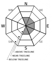
Bottom Line
LOW danger below and near treeline and MODERATE danger above treeline continues. Remain attentive for wind drifted snow at higher elevations on Mount Shasta. Gale force, westerly wind and a few inches of fresh snow is forecast for today.


Avalanche Problem 1: Wind Slab
-
Character ?

-
Aspect/Elevation ?
-
Likelihood ?CertainVery LikelyLikelyPossible
 Unlikely
 -
Size ?HistoricVery LargeLargeSmall

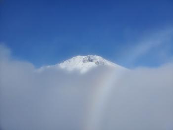
Above treeline on Mount Shasta, fresh snow and strong westerly wind may form new, small wind slabs and/or increase size and distribution of existing wind slabs today. Easterly aspects is where you're most likely to find said wind slabs. The warm, moist nature of our recent storms has kept snow transport to a minimum at lower elevations and thus, wind slabs have been small and difficult to trigger. Colder, higher elevations may be different. Cornices, wind pillows and ridgetop scouring are good clues to determine where wind slabs could be near.
Forecast Discussion
Buried in an avalanche? Seconds matter. Shoveling is the most time consuming phase of an avalanche rescue. Learn the basics of strategic shoveling.
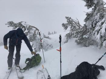
Recent Observations
- In the last 24 hours at treeline on Mount Shasta, temperatures have ranged from 28 to 31°F with average wind speeds of 18 mi/hr, gusts to 37 mi/hr out of the west/northwest.
- One to three inches of condensed, moist new snow. Total height of snow 43 inches on a NW facing slope near treeline. A variety of crusts exist, some supportable on skis, not boots. Boot penetration 4 - 6 inches. Heavy mist formed a thin zipper crust on top of new snow above treeline.
- Precipitation: nil
- Sky: cloudy/fog/poor visibility
- Westerly wind blowing 15-20 mi/hr with gusts to 30 mi/hr
- No recent avalanche activity or obvious signs of instability
Weather and Current Conditions
Weather Summary
Thus far, our spurts of rain and snow this week have been under-whelming. Out of all the rapid fire storms we've seen, today might be the most influential of the weather firing our way. This morning, satellite and radar models show precipitation arriving onshore and spreading inland, albeit slightly to the north of us. The westerly moving system will dump most of its precipitation along the coastal mountains. We should get seconds out of it. Snow levels will fall within the 5,500 to 6,000 foot range. Forecast models indicate 5 to 9 inches of snow at Bunny Flat today but I'd be surprised if we observe that much. However...when it comes to fresh snow, I love being fooled! Gale force wind blowing out of the west will be encountered above treeline.
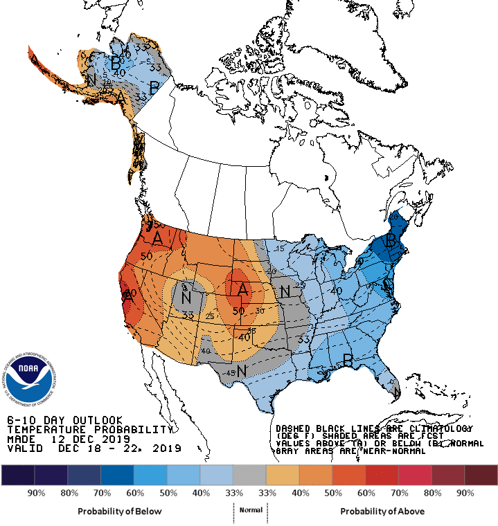
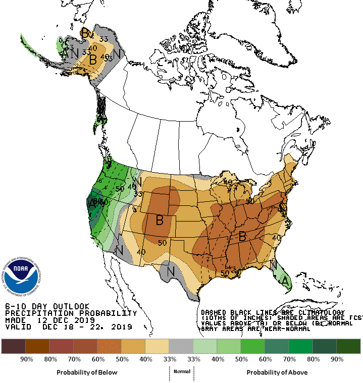
BELOW: 6-10 day temperature and precipitation forecasts. More like these can be found HERE.
24 Hour Weather Station Data @ 4:00 AM
| Weather Station | Temp (°F) | Wind (mi/hr) | Snow (in) | Comments | ||||||||
|---|---|---|---|---|---|---|---|---|---|---|---|---|
| Cur | Min | Max | Avg | Avg | Max Gust | Dir | Depth | New | Water Equivalent | Settlement | ||
| Mt. Shasta City (3540 ft) | 39 | 29 | 43 | 36 | 2 | N | ||||||
| Sand Flat (6750 ft) | 32 | 32 | 34 | 33 | 31 | 0 | 0 | 0 | ||||
| Ski Bowl (7600 ft) | 28.5 | 28 | 31 | 29.5 | 39.5 | 0 | 0 | 1 | ||||
| Gray Butte (8000 ft) | 28 | 27 | 30 | 28.5 | 18 | 37 | WNW | |||||
| Castle Lake (5870 ft) | 0 | 0 | 0 | 0 | 0 | 0 | 0 | down | ||||
| Mount Eddy (6509 ft) | 31.5 | 30.5 | 36 | 33 | 1 | 12 | SSE | 26 | 0 | 1 | ||
| Ash Creek Bowl (7250 ft) | down | |||||||||||
| Ash Creek Ridge (7895 ft) | down |
Two Day Mountain Weather Forecast
Produced in partnership with the Medford NWS
| For 7000 ft to 9000 ft | |||
|---|---|---|---|
|
Friday (4 a.m. to 10 p.m.) |
Friday Night (10 p.m. to 4 a.m.) |
Saturday (4 a.m. to 10 p.m.) |
|
| Weather | Snow, temperatures falling to 28 by 9am. Breezy. Chance of precipitation 100%. Snow levels near 5,800 feet. | Snow showers, mainly before 10pm. Chance of precipitation 90%. Snow level near 4,800 feet. | Snow showers, partly cloudy, clearing. Chance of precipitation 60%. Snow levels near town. |
| Temperature (°F) | 33 | 23 | 29 |
| Wind (mi/hr) | Southwest 10-15 | West 5-10 | Northwest 0-5 |
| Precipitation SWE / Snowfall (in) | 0.56 / 4-8 | 0.02 / 1-2 | 0.10 / 0-0.50 |
| For 9000 ft to 11000 ft | |||
| Friday | Friday Night | Saturday | |
| Weather | Snow, heavy at times. Windy. Wind chill as low as -7 F. Chance of precipitation 100%. | Snow showers, mainly before 10pm. Chance of precipitation 90%. Windy. Wind chill values as low as -11 F. | Snow showers, partly cloudy, clearing. Chance of precipitation 60%. Windy. Wind chill values as low as -17 F. |
| Temperature (°F) | 22 | 11 | 11 |
| Wind (mi/hr) | West 40-50 | West 30-40 | Northwest 10-20 |
| Precipitation SWE / Snowfall (in) | 0.56 / 5-9 | 0.02 / 2-3 | 0.10 / 0-1 |
Season Precipitation for Mount Shasta City
| Period | Measured (in) | Normal (in) | Percent of Normal (%) |
|---|---|---|---|
| From Oct 1, 2025 (the wet season) | 7.77 | 10.18 | 76 |
| Month to Date (since Jun 1, 2026) | 5.09 | 2.82 | 180 |
| Year to Date (since Jan 1, 2026) | 45.51 | 38.18 | 119 |

