

You are here
Avalanche Forecast for 2019-12-23 07:00
- EXPIRED ON December 24, 2019 @ 7:00 amPublished on December 23, 2019 @ 7:00 am
- Issued by Ryan Sorenson - Mount Shasta Avalanche Center
Bottom Line
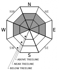
Avalanche danger will remain MODERATE near and above treeline today. New snow and strong south winds have likely formed wind slabs on northerly and westerly aspects. Be observant of wind drifted snow. Icy conditions may still be present on scoured slopes.


Avalanche Problem 1: Wind Slab
-
Character ?

-
Aspect/Elevation ?
-
Likelihood ?CertainVery LikelyLikelyPossible
 Unlikely
 -
Size ?HistoricVery LargeLargeSmall

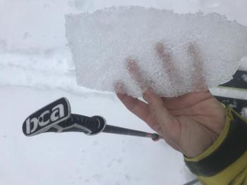
Over the last three days strong wind with gale force gusts have blown out of the south. Wind slabs found at Castle Lake yesterday were unreactive to trigger. However, colder temperatures could allow wind slabs to remain reactive at higher elevations. Look for wind slabs on the leeward side of ridges. Cornices, wind pillows and ridgetop scouring are good clues to determine where wind slabs are located.
Other signs of a wind slab problems include:
- Shooting cracks, blocking, whumphing
- Convex pillows of wind-drifted snow
- Chalky, hollow sounding snow
Forecast Discussion
Granular snow found beneath the ice crust was reactive in column and block tests at Castle Lake. Though the crusts above this layer was stout and difficult to break, more significant snow atop the snowpack may make this layer more of a concern in the future. Click here for more information.
Though an ice cap that formed December 19th decreased the overall available snow for transport, new snow yesterday has likely formed wind slabs on northerly and westerly aspects. The ice layer could be an ideal surface for new wind slabs to run on.
Recent Observations
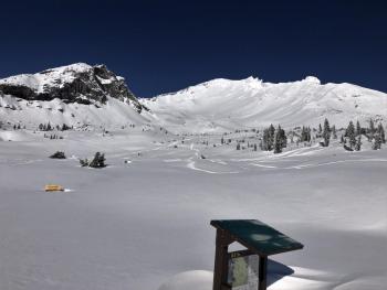
A tour up Left Peak at Castle Lake yesterday saw an average of 41 inches of snow at 6,100 feet. Five to ten inches of new snow sat atop the ice crust from December 19th. Light to moderate winds out of the southeast were actively loading north and west aspects. Drifts up to 2 feet deep were found along the ridgeline. New cornices were forming but were unreactive to ski cuts. Some whumphing was experienced but was isolated and localized to under the skis. Variability in the existence of the ice crust from December 19th will introduce some uncertainty around some areas below 6,000 feet. Small avalanches in isolated areas below treeline are unlikely however not impossible.
- In the last 24 hours at treeline, Mount Shasta has received 7 inches of snow, temperatures have ranged from 13 to 25°F with average wind speeds of 14 mi/hr, gusts to 43 mi/hr out of the south and east.
- Wind shifted out of the north and west last night.
- A large and widespread ice layer exists below new snow above 6,000 feet.
Weather and Current Conditions
Weather Summary
The wind will decrease and shift to the northeast as clouds gradually clear this morning. Mostly clear conditions will prevail through tomorrow afternoon. We will have a chance of snow after 4 p.m. tomorrow due to a small fast moving storm. This storm is more like a small brook compared to the atmospheric river we have been seeing. However, it is trickling down from the far north this time bringing colder temperatures and low snow levels. We could wake up to 1 to 3 inches of new snow above 2,000 feet on Christmas morning.
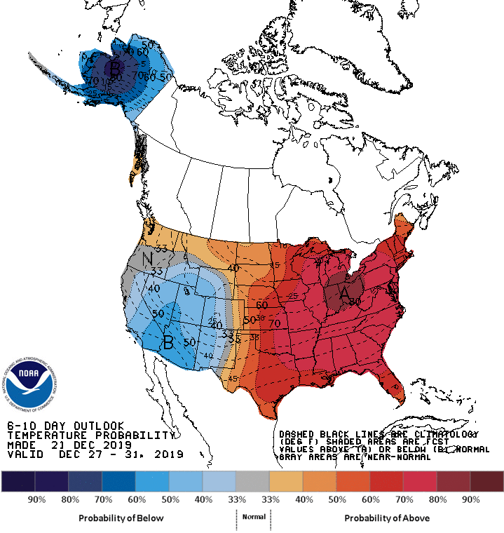
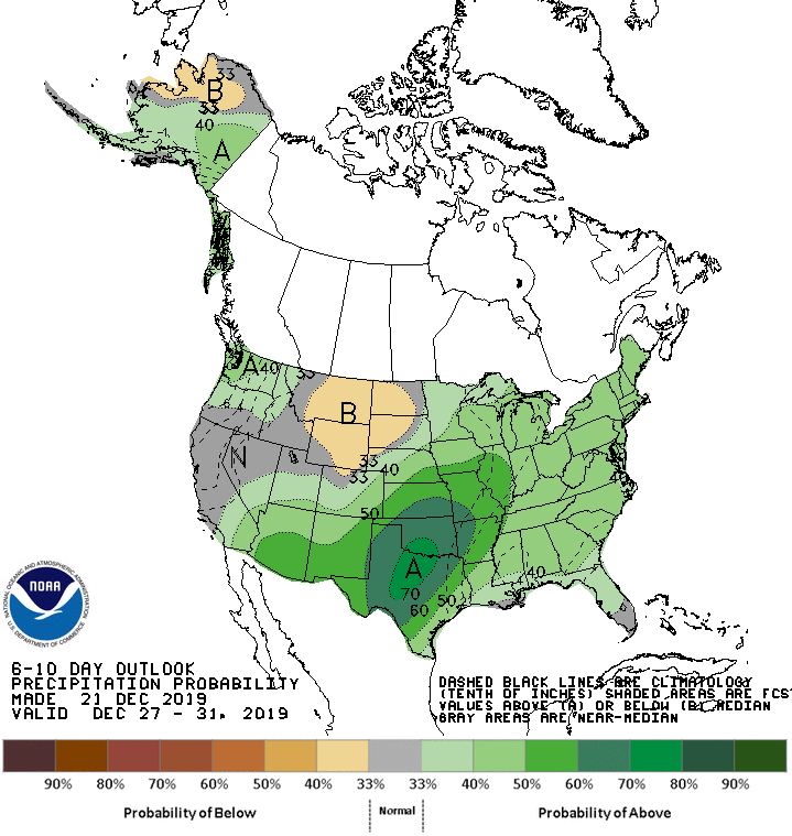
BELOW: 6-10 day temperature and precipitation forecasts. More like these can be found HERE.
24 Hour Weather Station Data @ 6:00
| Weather Station | Temp (°F) | Wind (mi/hr) | Snow (in) | Comments | ||||||||
|---|---|---|---|---|---|---|---|---|---|---|---|---|
| Cur | Min | Max | Avg | Avg | Max Gust | Dir | Depth | New | Water Equivalent | Settlement | ||
| Mt. Shasta City (3540 ft) | 25 | 25 | 44 | 32.5 | 1 | N | ||||||
| Sand Flat (6750 ft) | 13 | 13 | 30 | 23.5 | 40.7 | 5.8 | ||||||
| Ski Bowl (7600 ft) | 13.5 | 13.5 | 25.5 | 21 | 50.7 | 7.8 | .61 | 2 | ||||
| Gray Butte (8000 ft) | 16 | 12.5 | 23.5 | 19 | 13 | 31 | E | |||||
| Castle Lake (5870 ft) | ||||||||||||
| Mount Eddy (6509 ft) | 16.5 | 14 | 30 | 22.5 | 2 | 20 | SW | 35.7 | 3.8 | 0 | ||
| Ash Creek Bowl (7250 ft) | ||||||||||||
| Ash Creek Ridge (7895 ft) |
Two Day Mountain Weather Forecast
Produced in partnership with the Medford NWS
| For 7000 ft to 9000 ft | |||
|---|---|---|---|
|
Monday (4 a.m. to 10 p.m.) |
Monday Night (10 p.m. to 4 a.m.) |
Tuesday (4 a.m. to 10 p.m.) |
|
| Weather | Mostly sunny, clear skies after 10 am. | Mostly clear, lows in the lower to mid 20s. | Increasing clouds, mainly after 4pm. A 30 percent chance of snow. Snow levels near 2,000 feet. New snow accumulation of less than a half inch possible. |
| Temperature (°F) | 33 | 20 | 28 |
| Wind (mi/hr) | North 0-5 | Northeast 0-5 | South 0-5 |
| Precipitation SWE / Snowfall (in) | 0.00 / 0 | 0.00 / 0 | 0.03 / 0-0.50 |
| For 9000 ft to 11000 ft | |||
| Monday | Monday Night | Tuesday | |
| Weather | Mostly cloudy, then clearing after 10am. Wind chill values as low as -7 F. | Mostly clear. Wind chill values as low as -2 F. | Increasing clouds and temperatures falling, mainly after 4pm. A 30 percent chance of snow. Wind chill values as low as -13 F. |
| Temperature (°F) | 16 | 15 | 15 |
| Wind (mi/hr) | Northeast 5-10 | Southeast 10-15 | West 10-15 |
| Precipitation SWE / Snowfall (in) | 0.00 / 0 | 0.00 / 0 | 0.03 / 0-0.50 |
Season Precipitation for Mount Shasta City
| Period | Measured (in) | Normal (in) | Percent of Normal (%) |
|---|---|---|---|
| From Oct 1, 2025 (the wet season) | 8.87 | 12.88 | 69 |
| Month to Date (since Jul 1, 2026) | 6.19 | 5.52 | 112 |
| Year to Date (since Jan 1, 2026) | 46.61 | 40.88 | 114 |

