

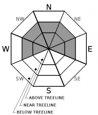
You are here
Avalanche Forecast for 2019-12-24 06:00
- EXPIRED ON December 25, 2019 @ 6:00 amPublished on December 24, 2019 @ 6:00 am
- Issued by Aaron Beverly - Mount Shasta Avalanche Center
Bottom Line
Avalanche danger is LOW. Natural and human triggered avalanches are unlikely, but small wind slabs may still exist in isolated or extreme terrain above treeline. A thick, wide spread crust still presents slippery conditions even with new snow on top. An ice axe and crampons are recommended if ascending high into the alpine.


Avalanche Problem 1: Wind Slab
-
Character ?

-
Aspect/Elevation ?
-
Likelihood ?CertainVery LikelyLikelyPossible
 Unlikely
 -
Size ?HistoricVery LargeLargeSmall

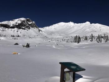
Though no signs of wind slabs have been encountered in the last couple of days, isolated areas above treeline show signs of scouring. Continue to keep an eye out for them particularly on northerly aspects high above treeline.
Remember that even though avalanche danger is low, isolated or extreme terrain may still host small slabs. Always carry a shovel, beacon, and probe and know how to use them.
Forecast Discussion
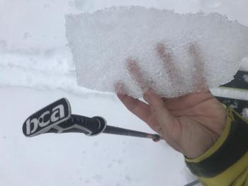
New snow is not well bonded to the widespread crust near and above treeline. You can easily slip on it particularly in areas where the new snow is thin. Ice axe and crampons are recommended if ascending steep slopes.
Recent Observations
In the last 24 hours on Mount Shasta, temperatures have remained below freezing and winds have been light.
No snow transport was observed, though plenty of light snow is available for it. Some scouring was seen on south facing aspects, but very little wind affect was observed overall.
Yesterday, column tests on a northeast aspect of Gray Butte yielded no notable results. No winds slabs were encountered. Small cornices were unreactive. No signs of avalanche danger were seen.
A stout crust exists below 5-8 inches of low density snow. Snowmobile tracks will spin out on this at times, and break through at others. Skiers will find it supportable and will have to stomp hard to break trail on steep slopes. You could slide for a ways on this crust where the snow on top is thin.
Weather and Current Conditions
Weather Summary
Snow flakes will add to the holiday cheer, but no game changing snow will fall in the next couple of days. Expect less than an inch in the next 24 hours accompanied by cold temperatures and light south and west winds. Another dusting should come our way tomorrow.
After that, high pressure will keep things cool and clear until the weekend when temperatures will rise and a bit more precipitation could come our way.
24 Hour Weather Station Data @
| Weather Station | Temp (°F) | Wind (mi/hr) | Snow (in) | Comments | ||||||||
|---|---|---|---|---|---|---|---|---|---|---|---|---|
| Cur | Min | Max | Avg | Avg | Max Gust | Dir | Depth | New | Water Equivalent | Settlement | ||
| Mt. Shasta City (3540 ft) | 21 | 21 | 38 | 27 | 1 | N | ||||||
| Sand Flat (6750 ft) | 14 | 10 | 28 | 16 | 39.3 | 0 | 0 | 2.3 | ||||
| Ski Bowl (7600 ft) | 14.5 | 13.5 | 26.5 | 18.5 | 50.4 | 0 | 0 | 0 | ||||
| Gray Butte (8000 ft) | 17.5 | 14.5 | 23.5 | 19 | 8 | 25 | E | |||||
| Castle Lake (5870 ft) | down | |||||||||||
| Mount Eddy (6509 ft) | 14 | 13.5 | 25 | 19 | 2 | 8 | E | 34.3 | 0 | 0 | ||
| Ash Creek Bowl (7250 ft) | down | |||||||||||
| Ash Creek Ridge (7895 ft) | down |
Two Day Mountain Weather Forecast
Produced in partnership with the Medford NWS
| For 7000 ft to 9000 ft | |||
|---|---|---|---|
|
Tuesday (4 a.m. to 10 p.m.) |
Tuesday Night (10 p.m. to 4 a.m.) |
Wednesday (4 a.m. to 10 p.m.) |
|
| Weather | Increasing clouds. A 30 percent chance of snow showers after 4 p.m. | Snow showers, mainly after 10 p.m. Chance of precipitation is 90%. | Snow showers likely, mainly before 10 a.m. Mostly cloudy. Chance of precipitation is 70%. |
| Temperature (°F) | 24 | 22 | 25 |
| Wind (mi/hr) | South 0-5 | South 5-10 | Southwest 0-5 |
| Precipitation SWE / Snowfall (in) | 0.00 / 0 | 0.04 / 0-1 | 0.06 / 0-1 |
| For 9000 ft to 11000 ft | |||
| Tuesday | Tuesday Night | Wednesday | |
| Weather | Increasing clouds. A 30 percent chance of snow showers after 4 p.m. Low wind chills. | Snow showers, mainly after 10 p.m. Low wind chills. Blustery. Chance of precipitation is 90%. | Snow showers likely, mainly before 10 a.m. Mostly cloudy. Low wind chills. Chance of precipitation is 70%. |
| Temperature (°F) | 15 | 11 | 12 |
| Wind (mi/hr) | West 10-15 | West 15-20 | North 10-15 |
| Precipitation SWE / Snowfall (in) | 0.00 / 0 | 0.04 / 0-1 | 0.06 / 0-1 |
Season Precipitation for Mount Shasta City
| Period | Measured (in) | Normal (in) | Percent of Normal (%) |
|---|---|---|---|
| From Oct 1, 2025 (the wet season) | 8.87 | 13.15 | 67 |
| Month to Date (since Jul 1, 2026) | 6.19 | 5.79 | 107 |
| Year to Date (since Jan 1, 2026) | 46.61 | 41.15 | 113 |

