

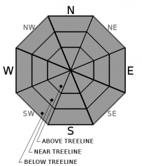
You are here
Avalanche Forecast for 2019-12-25 06:00
- EXPIRED ON December 26, 2019 @ 6:00 amPublished on December 25, 2019 @ 6:00 am
- Issued by Aaron Beverly - Mount Shasta Avalanche Center
Bottom Line
Avalanche danger is LOW. Exercise normal caution. Always watch for isolated slabs and know your basic avalanche rescue skills. Icy conditions exist in wind exposed areas. Use an ice axe and crampons if ascending steep slopes.


Avalanche Problem 1: Normal Caution
-
Character ?

-
Aspect/Elevation ?
-
Likelihood ?CertainVery LikelyLikelyPossible
 Unlikely
 -
Size ?HistoricVery LargeLargeSmall

Avalanche danger is low. Exercise normal caution. This means:
- Always watch for isolated slabs.
- Be especially careful if the avalanche forecast mentions deep or persistent instabilities.
- Basic avalanche rescue skills are always essential when you travel in avalanche terrain.
Forecast Discussion
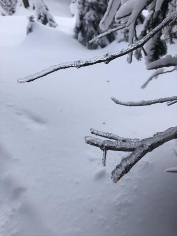
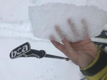
Calm to light winds and cold temperatures will continue to preserve the new snow received last Sunday. This snow sits atop a stout icy crust. The crust is completey exposed in places, but generally a chalky, wind affected snow sits on top. In less wind affected areas, you'll find low density snow struggling to bond to the icy surface beneath. If ascending high into the alpine or on steep slopes, bring an ice axe and crampons and know how to use them.
Recent Observations
In the last 24 hours on Mount Shasta, temperatures have remained below 21 deg F. Winds have been calm to light, peaking at 8 mi/hr. About an inch of new snow has fallen. The current snow depth at the Old Ski Bowl is 51 inches.
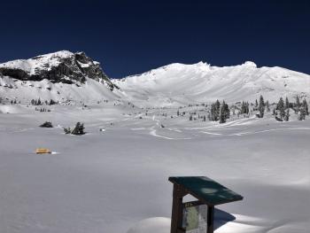
Avalanche Gulch and similar south facing areas and bordering ridges have received some wind affect. Soft, chalky surfaces, 2-8 inches, that are well bonded to the ice crust below, will be encountered. For snow sliding enthusiasts venturing above treeline, focus on gullies for the best conditions. Look out for pockets of thin snow sitting atop that infamous crust. They can knock you off your feet.
No instabilities or obvious signs of avalanches have been observed in the last three days. Yesterday, there was very little wind transport of snow. Cornices were small and would not budge. No signs of a wind slab problem were seen.
Weather and Current Conditions
Weather Summary
Expect a dusting of snow today down to 3,000 ft - up to an inch if we are lucky. Calm to light winds will change from the south to the north. When point forecasts predict near 10 mi/hr winds at 10,000 ft, plan on bringing a candle to light your way.
Tonight, the skies will begin to clear as high pressure starts to dominate the region. A smidgen of precipitation may come our way on Sunday, but it is barely worth mentioning at this point.
Cold conditions will prevail until Friday morning. Freezing levels will jump up to 9,000 ft Saturday.
24 Hour Weather Station Data @ 5:00 AM
| Weather Station | Temp (°F) | Wind (mi/hr) | Snow (in) | Comments | ||||||||
|---|---|---|---|---|---|---|---|---|---|---|---|---|
| Cur | Min | Max | Avg | Avg | Max Gust | Dir | Depth | New | Water Equivalent | Settlement | ||
| Mt. Shasta City (3540 ft) | 30 | 20 | 36 | 30.5 | 1 | N | ||||||
| Sand Flat (6750 ft) | 21 | 14 | 26 | 21 | 39 | 0 | 0 | 0 | ||||
| Ski Bowl (7600 ft) | 17 | 14.5 | 21 | 17 | 51 | 1 | 0.14 | 0 | ||||
| Gray Butte (8000 ft) | 16.5 | 15.5 | 18 | 16.5 | 5 | 12 | W | |||||
| Castle Lake (5870 ft) | down | |||||||||||
| Mount Eddy (6509 ft) | 18.5 | 13.5 | 25 | 20 | 1 | 5 | WSW | 34.9 | 1 | 0 | ||
| Ash Creek Bowl (7250 ft) | down | |||||||||||
| Ash Creek Ridge (7895 ft) | down |
Two Day Mountain Weather Forecast
Produced in partnership with the Medford NWS
| For 7000 ft to 9000 ft | |||
|---|---|---|---|
|
Wednesday (4 a.m. to 10 p.m.) |
Wednesday Night (10 p.m. to 4 a.m.) |
Thursday (4 a.m. to 10 p.m.) |
|
| Weather | Snow showers likely, mainly before 10 a.m. Mostly cloudy. Chance of precipitation is 70%. | Mostly cloudy, then gradually becoming mostly clear. | Sunny. |
| Temperature (°F) | 25 | 19 | 29 |
| Wind (mi/hr) | South 5-10 | Northeast 5-10 | Northeast 5-10 |
| Precipitation SWE / Snowfall (in) | 0.07 / 0-1 | 0.00 / 0 | 0.00 / 0 |
| For 9000 ft to 11000 ft | |||
| Wednesday | Wednesday Night | Thursday | |
| Weather | Snow showers likely, mainly before 10 a.m. Mostly cloudy and cold. Chance of precipitation is 70%. | A 20 percent chance of snow showers before 10 p.m. Mostly cloudy, then gradually becoming mostly clear. Low wind chills. | Sunny. Low wind chills. |
| Temperature (°F) | 15 | 12 | 18 |
| Wind (mi/hr) | Southeast 5-10 | Northeast 5-10 | Northeast 15-20 |
| Precipitation SWE / Snowfall (in) | 0.07 / 0-1 | 0.00 / 0 | 0.00 / 0 |
Season Precipitation for Mount Shasta City
| Period | Measured (in) | Normal (in) | Percent of Normal (%) |
|---|---|---|---|
| From Oct 1, 2025 (the wet season) | 8.88 | 13.41 | 66 |
| Month to Date (since Jul 1, 2026) | 6.20 | 6.05 | 102 |
| Year to Date (since Jan 1, 2026) | 46.62 | 41.41 | 113 |

