

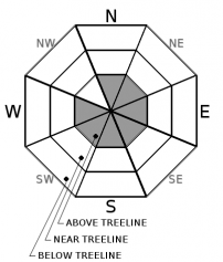
You are here
Avalanche Forecast for 2019-12-31 06:55
- EXPIRED ON January 1, 2020 @ 6:55 amPublished on December 31, 2019 @ 6:55 am
- Issued by Ryan Sorenson - Mount Shasta Avalanche Center
Bottom Line
LOW avalanche danger is expected throughout the forecast area today. Small wind slabs could develop late this evening on isolated steep terrain above 9,000 feet as one to four inches of new snow is expected. While unlikely, wet slab avalanche problems could develop this evening on isolated steep terrain if more warming or rain occurs than forecasted. Previously wind scoured slopes are extremely icy. Use caution if traveling above treeline as the icy slopes present slide for life conditions.


Avalanche Problem 1: Wind Slab
-
Character ?

-
Aspect/Elevation ?
-
Likelihood ?CertainVery LikelyLikelyPossible
 Unlikely
 -
Size ?HistoricVery LargeLargeSmall

Snow totals of one to four inches are possible above 9,000 feet after 10 pm tonight. Strong winds out of the northwest could build fresh wind slabs on isolated steep terrain above treeline. These wind slabs are expected to be small and difficult to trigger, however use caution if fresh cornices, wind pillows or drifts are encountered tonight.
Forecast Discussion
While unlikely, wet slab avalanche problems could develop this evening on isolated steep south facing terrain if more warming or rain occurs than forecasted. Isolated wet slab slides could form on steep terrain below treeline as rain lubricates the current snow ice interface.
Buried surface hoar layers were found in the snowpack on protected north facing terrain near and below treeline on Left Peak, Castle Lake yesterday. Currently, these layers pose little hazard, however this is something to monitor if we get a significant amount of snow in the near future. Click here for more information.
Recent Observations
- Temperatures have ranged from 27 to 35 degrees F in the last 24 hours near 8,000 feet.
- The wind remained light to moderate out of the east yesterday.
- In the last 24 hours wind speeds have averaged 7 mi/hr, gusting up to 31 mi/hr at 8,000 feet .
- The height of snow (HS) at 7,600 feet is 45.5 inches.
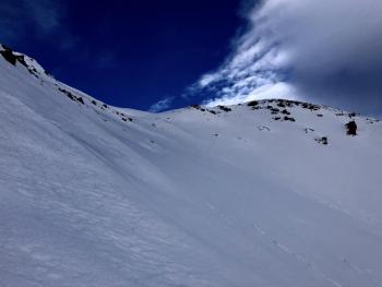
- Very icy ridgelines, moraine tops and variable sastrugi formations can be found above treeline.
- Below treeline snow conditions are variable with a dusting of new snow over a variety of melt freeze and wind crusts.
- Soft snow can be found on protected north facing slopes below treeline.
- No recent avalanches or signs of instability have been observed.
Weather and Current Conditions
Weather Summary
Mostly sunny and dry conditions will continue today. Light to moderate winds are expected out of the northwest.
Rain and snow is likely mostly after 10 pm this evening. Warming temperatures could bring snow levels as high as 9,000 feet. Snow totals of one to four inches are possible above 9,000 feet as we bring in the New Year. Snow showers will continue on New Year's Day mainly before 10 am. New snow accumulation of an inch is possible. Snow levels near 8,000 feet are expected to decrease to 6,200 feet tomorrow afternoon.
24 Hour Weather Station Data @ 5:00 AM
| Weather Station | Temp (°F) | Wind (mi/hr) | Snow (in) | Comments | ||||||||
|---|---|---|---|---|---|---|---|---|---|---|---|---|
| Cur | Min | Max | Avg | Avg | Max Gust | Dir | Depth | New | Water Equivalent | Settlement | ||
| Mt. Shasta City (3540 ft) | 34 | 30 | 43 | 34.5 | 2 | N | ||||||
| Sand Flat (6750 ft) | 25 | 20 | 34 | 26 | 39 | 0 | 0 | 0 | ||||
| Ski Bowl (7600 ft) | 31.5 | 25 | 36.5 | 30 | 45.7 | 0 | 0 | 0 | ||||
| Gray Butte (8000 ft) | 35 | 27 | 35 | 31 | 8 | 31 | E | |||||
| Castle Lake (5870 ft) | 0 | 0 | 0 | 0 | 0 | 0 | 0 | down | ||||
| Mount Eddy (6509 ft) | 36 | 27.5 | 36 | 32.5 | 2 | 11 | SSW | 33.6 | 0 | 0 | ||
| Ash Creek Bowl (7250 ft) | down | |||||||||||
| Ash Creek Ridge (7895 ft) | down |
Two Day Mountain Weather Forecast
Produced in partnership with the Medford NWS
| For 7000 ft to 9000 ft | |||
|---|---|---|---|
|
Tuesday (4 a.m. to 10 p.m.) |
Tuesday Night (10 p.m. to 4 a.m.) |
Wednesday (4 a.m. to 10 p.m.) |
|
| Weather | Mostly Sunny. | Mostly cloudy. Rain likely after 10 pm. Snow levels increasing to 9,000 feet. Chance of precipitation is 60%. | Mostly cloudy. Rain showers likely before 10 am. Then a chance of snow showers. Snow levels near 8,000 feet decreasing to 6,200 feet after noon. |
| Temperature (°F) | 43 | 35 | 39 |
| Wind (mi/hr) | North 10-15 | Northwest 15-20 | West 15-20 |
| Precipitation SWE / Snowfall (in) | 0.00 / 0 | 0.12 / 0-2 | 0.11 / 0-2 |
| For 9000 ft to 11000 ft | |||
| Tuesday | Tuesday Night | Wednesday | |
| Weather | Sunny. Blustery. Gusty. | Snow likely after 10 pm. Chance of precipitation is 60%. Windy and gusty. | Snow showers likely mainly before 10 am. Chance of precipitation is 70%. Windy and gusty. |
| Temperature (°F) | 33 | 26 | 26 |
| Wind (mi/hr) | North 30-35 | Northwest 40-45 | Northwest 45-50 |
| Precipitation SWE / Snowfall (in) | 0.00 / 0 | 0.12 / 1-4 | 0.11 / 1-3 |
Season Precipitation for Mount Shasta City
| Period | Measured (in) | Normal (in) | Percent of Normal (%) |
|---|---|---|---|
| From Oct 1, 2025 (the wet season) | 8.93 | 14.96 | 60 |
| Month to Date (since Jul 1, 2026) | 6.25 | 7.60 | 82 |
| Year to Date (since Jan 1, 2026) | 46.67 | 42.96 | 109 |

