

You are here
Avalanche Forecast for 2020-01-01 05:46
- EXPIRED ON January 2, 2020 @ 5:46 amPublished on January 1, 2020 @ 5:46 am
- Issued by Nick Meyers - Shasta-Trinity National Forest
Bottom Line
LOW avalanche danger will prevail for all elevations and aspects today. Watch for small wind slabs in isolated areas or extreme terrain. Strong, northwesterly gales will blow over higher ground. Wind scoured ridgelines and exposed moraine tops are extremely icy and perhaps the greatest hazard in the backcountry currently. Self-arrest is near impossible.


Avalanche Problem 1: Normal Caution
-
Character ?

-
Aspect/Elevation ?
-
Likelihood ?CertainVery LikelyLikelyPossible
 Unlikely
 -
Size ?HistoricVery LargeLargeSmall

LOW avalanche danger and normal caution is advised for today. Generally safe avalanche conditions exist. Natural and human triggered avalanches are unlikely. Watch for unstable snow on isolated terrain features.
Less than a tenth of an inch of water and warm temperatures has brought rain on snow to near 9,000 feet this morning. Strong wind is forecast for today out of the northwest. Available snow for transport is limited, but blowing snow is still expected when gale force winds are occurring. A trace of new snow is likely in alpine terrain. Wind and precipitation will diminish into the evening.
Use normal caution while traveling in the backcountry today:
- Carry proper rescue equipment: beacon, shovel probe. An ice axe and crampons is advised as well with current, icy conditions.
- Ski/ride one at a time in avalanche terrain
- Don't regroup in avalanche run out zones
- Watch for wind blowing snow
- Look for isolated slabs/unstable snow in steep terrain
Forecast Discussion

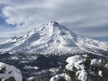
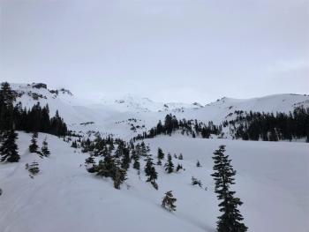
Mount Shasta's east side, viewed from Ash Creek Butte on 12.31.19. [Photo: Meyers]
Recent Observations
In the last 24 hours:
- Temperatures have ranged from 31 to 45 degrees F at 8,000 feet.
- Wind speeds have averaged 12 mi/hr, gusting up to 55 mi/hr at 8,000 feet.
- The height of snow (HS) at 7,600 feet is 45.5 inches.
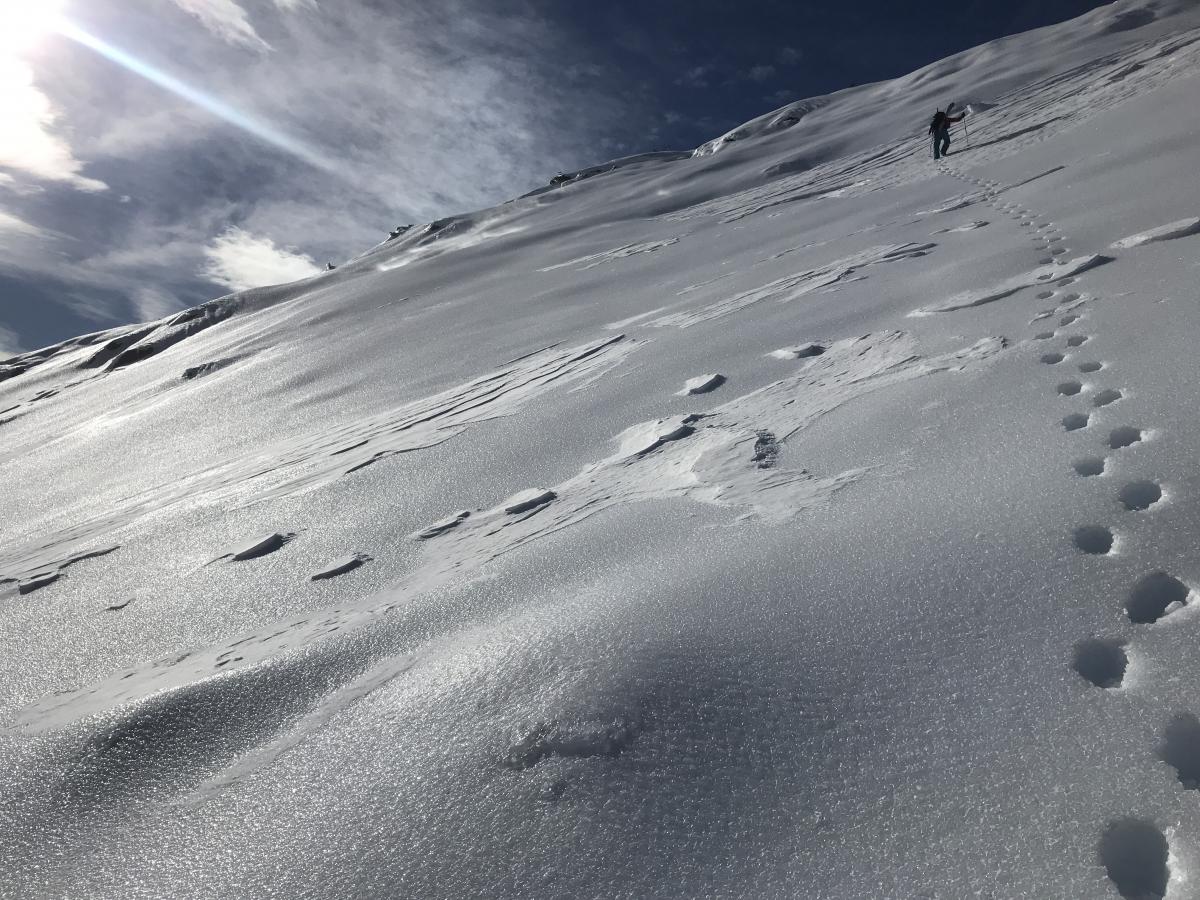
- Very icy ridgelines and moraine tops exist near and above treeline with a variety of hard to soft wind slabs and sastrugi formations.
- Below treeline, snow conditions are variable. Some soft snow can be found on protected north facing slopes below treeline.
- No recent avalanches or signs of instability have been observed.
- Buried surface hoar layers have been found in the snowpack on protected north facing terrain near and below treeline in the Castle Lake area. Only slightly buried, this layer does not represent a current avalanche problem, but will require further monitoring.
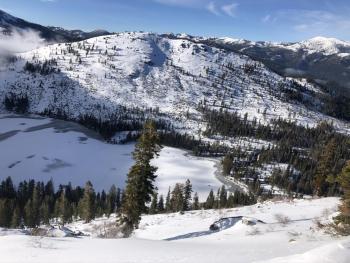
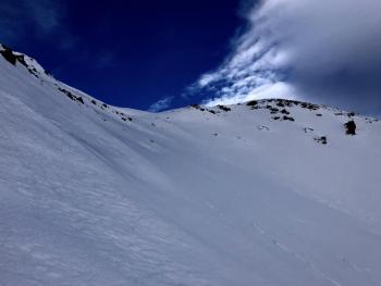
Above: The now famous 12/19 ice crust, exposed in all its glory due to a period of high winds and modest precipitation. The marbleized, glazed and very icy snow surface allows for some boot penetration, however a slip and fall on this stuff would host dire consequences. This crust is widespread throughout the forecast area and is either exposed, like in this photo, or lurking beneath variable soft to hard wind slabs, sastrugis, crusts and pockets of soft snow in protected areas. We've had a few small wind slabs fail on this ice layer; no large avalanches. It will be interesting to see how this layer plays out over the remaining winter. [Photo: N Meyers / Ash Creek Butte / 12.31.19]
Weather and Current Conditions
Weather Summary
A front moves inland over the region this morning bringing warm temperatures and widespread rain. Precip totals will be minimal for rain and hardly measureable for snow. Snow levels near 9,000 feet this morning should lower to 5,000 - 6,000 feet this afternoon. Precipitation will gradually decrease into the evening. A mid-level westerly moving jet of 50 - 60 knots will bring strong, gusty winds to higher terrain over today and tonight.
Friday night is the next best chance of precipitation.
24 Hour Weather Station Data @ 4:00 AM
| Weather Station | Temp (°F) | Wind (mi/hr) | Snow (in) | Comments | ||||||||
|---|---|---|---|---|---|---|---|---|---|---|---|---|
| Cur | Min | Max | Avg | Avg | Max Gust | Dir | Depth | New | Water Equivalent | Settlement | ||
| Mt. Shasta City (3540 ft) | 39 | 33 | 48 | 40 | 2 | N | ||||||
| Sand Flat (6750 ft) | 39 | 26 | 43 | 37 | 40 | 0 | .08 | 0 | ||||
| Ski Bowl (7600 ft) | 36.5 | 31.5 | 45.5 | 38.5 | 43.8 | 0 | 0.06 | 2 | ||||
| Gray Butte (8000 ft) | 35.5 | 35 | 43 | 38 | 12 | 55 | NW | |||||
| Castle Lake (5870 ft) | 0 | 0 | 0 | 0 | 0 | 0 | 0 | down | ||||
| Mount Eddy (6509 ft) | 41.5 | 36 | 46 | 41 | 2 | 14 | SE | 32.4 | 0 | 1 | ||
| Ash Creek Bowl (7250 ft) | down | |||||||||||
| Ash Creek Ridge (7895 ft) | down |
Two Day Mountain Weather Forecast
Produced in partnership with the Medford NWS
| For 7000 ft to 9000 ft | |||
|---|---|---|---|
|
Wednesday (4 a.m. to 10 p.m.) |
Wednesday Night (10 p.m. to 4 a.m.) |
Thursday (4 a.m. to 10 p.m.) |
|
| Weather | Rain showers likely before 10am, then a chance of rain and snow showers between 10am and 1pm, then a chance of snow showers after 1pm. Cloudy, then gradually becoming mostly sunny. Breezy. Snow level at 8,000 feet, decreasing to 6,200 feet. | A 30 percent chance of snow showers, mainly before 10pm. Partly cloudy. Windy. Snow level near 4,700 feet. | Mostly sunny. |
| Temperature (°F) | 37 | 30 | 37 |
| Wind (mi/hr) | West 15-25 | Northwest 15-25 | Northwest 15-20 |
| Precipitation SWE / Snowfall (in) | 0.07 / 0-0.50 | 0.00 / 0-0.25 | 0.00 / 0 |
| For 9000 ft to 11000 ft | |||
| Wednesday | Wednesday Night | Thursday | |
| Weather | Snow showers likely, mainly before 10am. Mostly cloudy, falling temperatures. Windy. Wind chill values as low as -2. Chance of precipitation is 70%. | A 40 percent chance of snow showers. Little accumulation expected. Partly cloudy, Windy. Wind chill values as low as -3. | Mostly sunny, windy. |
| Temperature (°F) | 26 | 23 | 29 |
| Wind (mi/hr) | Northwest 50-60 | Northwest 50-60 | Northwest 40-50 |
| Precipitation SWE / Snowfall (in) | 0.07 / 2-4 | 0.00 / 0-0.25 | 0.00 / 0 |
Season Precipitation for Mount Shasta City
| Period | Measured (in) | Normal (in) | Percent of Normal (%) |
|---|---|---|---|
| From Oct 1, 2025 (the wet season) | 8.93 | 15.21 | 59 |
| Month to Date (since Jun 1, 2026) | 6.25 | 7.85 | 80 |
| Year to Date (since Jan 1, 2026) | 46.67 | 43.21 | 108 |

