

You are here
Avalanche Forecast for 2020-01-03 05:37
- EXPIRED ON January 4, 2020 @ 5:37 amPublished on January 3, 2020 @ 5:37 am
- Issued by Nick Meyers - Shasta-Trinity National Forest
Bottom Line
LOW avalanche danger and normal caution is advised for today -- below, near and above treeline. A quick-hitting winter storm is forecast to impact the area late tonight. A couple inches of new snow is likely with strong wind out of the south/southwest.
Continue to use caution on icy ridges and watch for overhead rime ice hazard in alpine terrain.


Avalanche Problem 1: Normal Caution
-
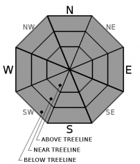
Character ?

-
Aspect/Elevation ?
-
Likelihood ?CertainVery LikelyLikelyPossible
 Unlikely
 -
Size ?HistoricVery LargeLargeSmall

A couple inches of new snow is likely tonight with strong wind out of the south/southwest. Watch for small, new wind slabs on isolated terrain features, if you find yourself out overnight. New wind slabs will rest on top of the 12/19 rain crust, but are not expected to be of significant size or distribution.
Use normal caution while traveling in the backcountry today:
- Carry proper rescue equipment: beacon, shovel probe. An ice axe and crampons is advised as well with current, icy conditions.
- Ski/ride one at a time in avalanche terrain
- Don't regroup in avalanche run out zones
- Watch for wind blowing snow
- Look for isolated slabs/unstable snow in steep terrain
Recent Observations
- Temperatures have ranged from 32 to 42 degrees F at 8,000 feet.
- Wind speeds have averaged 23 mi/hr, gusting up to 67 mi/hr at 8,000 feet.
- The height of snow (HS) at 7,900 feet is 43 inches.
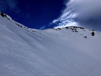
- Little to no change since yesterday. Snow surfaces below, near and above treeline are a wide variety of breakable crust, soft to hard wind slabs, scoured and icy. Soft powder snow is a thing of the past.
- Gale force winds continued yesterday near/above treeline. Blowing snow was visible; wind loading was minimal.
- No recent avalanches or obvious signs of instability have been observed.
- The snowpack has suffered quite the punishment from high winds and wildly fluctuating temperatures.
Weather and Current Conditions
Weather Summary
Increasing clouds today will signify the approaching cold front and low pressure system, currently off the B.C. coast this morning. The low will move onshore tonight and bring gusty southwesterly winds and a short and sweet period of precipitation. The majority of the rain/snow will fall overnight, drying out into Saturday. Snow levels will linger near 5,300 feet tonight, lowering to 3,800 feet by tomorrow, however most of the precipitation will have already fallen. A nice little refresh for the rough and dirty snowpack; over- the-top face shots are unlikely.
24 Hour Weather Station Data @ 4:00 AM
| Weather Station | Temp (°F) | Wind (mi/hr) | Snow (in) | Comments | ||||||||
|---|---|---|---|---|---|---|---|---|---|---|---|---|
| Cur | Min | Max | Avg | Avg | Max Gust | Dir | Depth | New | Water Equivalent | Settlement | ||
| Mt. Shasta City (3540 ft) | 29 | 29 | 52 | 40.5 | 3 | N | ||||||
| Sand Flat (6750 ft) | 30 | 30 | 40 | 36 | 38 | 0 | 0 | 0 | ||||
| Ski Bowl (7600 ft) | 32.5 | 32 | 42.5 | 38.5 | 41.9 | 0 | 0 | 1 | ||||
| Gray Butte (8000 ft) | 35 | 33 | 41 | 37 | 23 | 67 | NNW | |||||
| Castle Lake (5870 ft) | 0 | 0 | 0 | 0 | 0 | 0 | 0 | down | ||||
| Mount Eddy (6509 ft) | 32.5 | 31 | 41.5 | 36 | 3 | 15 | SSE | 30.8 | 0 | 0 | ||
| Ash Creek Bowl (7250 ft) | down | |||||||||||
| Ash Creek Ridge (7895 ft) | down |
Two Day Mountain Weather Forecast
Produced in partnership with the Medford NWS
| For 7000 ft to 9000 ft | |||
|---|---|---|---|
|
Friday (4 a.m. to 10 p.m.) |
Friday Night (10 p.m. to 4 a.m.) |
Saturday (4 a.m. to 10 p.m.) |
|
| Weather | Partly sunny, with a temperature rising to near 42 by noon, then falling to around 32 during the remainder of the day. Breezy. | Snow, mainly after 10pm. Windy. Chance of precipitation is 100%. Snow level near 5,300 feet. | A 50 percent chance of snow showers before 10am. Mostly sunny. Snow levels near 3,800 feet. |
| Temperature (°F) | 42 | 31 | 27 |
| Wind (mi/hr) | South 5-15 | South 20-25 | West 5-10 |
| Precipitation SWE / Snowfall (in) | 0.01 / 0 | 0.23 / 3-5 | 0.03 / 0-0.50 |
| For 9000 ft to 11000 ft | |||
| Friday | Friday Night | Saturday | |
| Weather | Partly sunny, with a temperature falling to around 20 F by 5pm. Windy. Wind chill values as low as -5. | Snow, mainly after 10pm. The snow could be heavy at times. Windy. Wind chill values as low as -13. Chance of precipitation is 100%. | A 50 percent chance of snow showers before 10am. Mostly sunny. Windy. Wind chill values as low as -17. |
| Temperature (°F) | 32 | 12 | 18 |
| Wind (mi/hr) | Southwest 20-30 | Southwest 55-65 | West 20-30 |
| Precipitation SWE / Snowfall (in) | 0.01 / 0 | 0.23 / 4-6 | 0.03 / 0-0.50 |
Season Precipitation for Mount Shasta City
| Period | Measured (in) | Normal (in) | Percent of Normal (%) |
|---|---|---|---|
| From Oct 1, 2025 (the wet season) | 8.99 | 15.69 | 57 |
| Month to Date (since Jun 1, 2026) | 0.06 | 0.48 | 13 |
| Year to Date (since Jan 1, 2026) | 0.06 | 0.48 | 13 |

