

You are here
Avalanche Forecast for 2020-01-04 06:50
- EXPIRED ON January 5, 2020 @ 6:50 amPublished on January 4, 2020 @ 6:50 am
- Issued by Ryan Sorenson - Mount Shasta Avalanche Center
Bottom Line
A fast moving storm is currently impacting the area early this morning. Avalanche danger is MODERATE. Three to six inches of new snow with wind out of the south/southwest is predicted. Watch for wind slabs on steep terrain near and above treeline. Though natural avalanches are unlikely, small human triggered avalanches are possible primarily on N-NE-E -SE aspects. Use caution in alpine terrain today as icy patches and overhead rime ice hazards remain.


Avalanche Problem 1: Wind Slab
-
Character ?

-
Aspect/Elevation ?
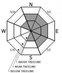
-
Likelihood ?CertainVery LikelyLikelyPossible
 Unlikely
 -
Size ?HistoricVery LargeLargeSmall

Three to six inches of new snow is predicted early this morning with strong winds out of the south/southwest. Nearly three inches of new snow has already been recorded at 7,600 feet on Mount Shasta since 3 am this morning. Cold temperatures could keep the new snow unconsolidated and allow for wind transport throughout the day. Watch for new wind slabs on N-NE-E -SE terrain near and above treeline. New wind slabs will rest atop the 12/19 rain crust. These could be reactive on leeward terrain. The size and distribution of wind slabs will grow as the wind is expected to shift to northwesterly. Wind slabs should remain small but could catch an unaware skier off guard. Consequences of a small wind slab avalanche could be magnified if associated with a terrain trap.
Evaluate snow and terrain carefully and identify features of concern. Look for clues of wind slab development such as blowing snow, wind scouring and shooting cracks. Communicate with your group and use safe travel practices such as "one at a time" where problematic wind slabs may exist.
Recent Observations
- Temperatures have ranged from 23 to 42 degrees F at 8,000 feet.
- Wind speeds have averaged 11 mi/hr, gusting up to 31 mi/hr at 8,000 feet.
- The last five hours have recorded strong south/southwest winds at 8,000 feet.
- The height of snow (HS) at 7,600 feet is 44.4 inches. / 2.8 inches of new snow has been recorded since 3 am.
- The snowpack has settled and consolidated over the last three days due to high winds and fluctuating temperatures.
- A hard supportable melt freeze crust over moist rounding snow was observed on north facing terrain on Left Peak, Castle Lake yesterday.
- A number of crusts, most of which are supportable, exist throughout the forecast area.
- No recent avalanches or obvious signs of instability have been observed.
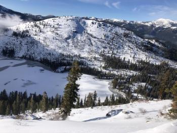
Below: Photo taken from Left Peak, Castle Lake looking west toward Middle and Right Peak. A shallow snowpack remains below treeline. 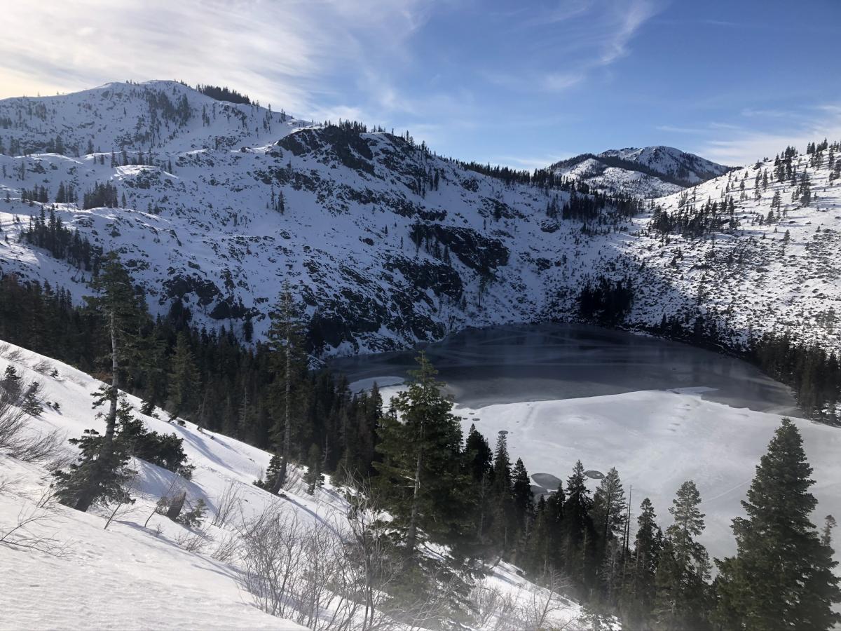

Weather and Current Conditions
Weather Summary
A fast moving storm currently impacting the forecast area will quickly move east of the area today. Snow showers are expected to dwindle this morning then give way to clearer skies this afternoon. The snow level will continue to drop throughout the day to near 4,100 feet although, most of the snow will fall early this morning when snow levels are near 5,000 feet. Clearer skies tonight will make for colder temperatures in the lower to mid 20s. Light northwest wind could bring wind chill values as low as -10 degrees F in the alpine today.
Another fast moving skiff of a storm will skip through the area tomorrow morning. Less than an inch of snow is possible with snow levels near 2,500 feet.
24 Hour Weather Station Data @ 5:00 AM
| Weather Station | Temp (°F) | Wind (mi/hr) | Snow (in) | Comments | ||||||||
|---|---|---|---|---|---|---|---|---|---|---|---|---|
| Cur | Min | Max | Avg | Avg | Max Gust | Dir | Depth | New | Water Equivalent | Settlement | ||
| Mt. Shasta City (3540 ft) | 37 | 28 | 57 | 42 | 3 | N | ||||||
| Sand Flat (6750 ft) | 28 | 28 | 44 | 34 | 36 | 2 | 0 | 0 | ||||
| Ski Bowl (7600 ft) | 24 | 24 | 45.5 | 33.5 | 44.4 | 2.8 | 0.14 | 0 | ||||
| Gray Butte (8000 ft) | 22.5 | 22.5 | 42.5 | 32 | 11 | 31 | WSW | |||||
| Castle Lake (5870 ft) | 0 | 0 | 0 | 0 | 0 | 0 | 0 | down | ||||
| Mount Eddy (6509 ft) | 28 | 27.5 | 46.5 | 35 | 2 | 12 | SSW | 29.9 | 1.6 | 0 | ||
| Ash Creek Bowl (7250 ft) | down | |||||||||||
| Ash Creek Ridge (7895 ft) | down |
Two Day Mountain Weather Forecast
Produced in partnership with the Medford NWS
| For 7000 ft to 9000 ft | |||
|---|---|---|---|
|
Saturday (4 a.m. to 10 p.m.) |
Saturday Night (10 p.m. to 4 a.m.) |
Sunday (4 a.m. to 10 p.m.) |
|
| Weather | A 70 percent chance of snow showers before 10am. Mostly cloudy in the morning then mostly sunny in the afternoon. Snow levels near 4,100 feet. | Mostly cloudy. | A slight chance of snow showers. Mostly cloudy. Snow levels near 3,800 feet. |
| Temperature (°F) | 33 | 24 | 31 |
| Wind (mi/hr) | West 5-10 | West 10-25 | West 5-10 |
| Precipitation SWE / Snowfall (in) | 0.03 / 1-3 | 0.00 / 0 | 0.01 / 0-0.50 |
| For 9000 ft to 11000 ft | |||
| Saturday | Saturday Night | Sunday | |
| Weather | A 70 percent chance of snow showers before 10am. Mostly cloudy in the morning then mostly sunny in the afternoon. Windy. Wind chill values as low as -10. | Mostly cloudy. Breezy. Wind chill values as low as -16. | A slight chance of snow showers. Partly sunny. Windy. Wind chill values as low as -18. |
| Temperature (°F) | 21 | 10 | 19 |
| Wind (mi/hr) | West 15-20 | Southwest 10-15 | West 20-25 |
| Precipitation SWE / Snowfall (in) | 0.03 / 1-3 | 0.00 / 0 | 0.01 / 0-0.50 |
Season Precipitation for Mount Shasta City
| Period | Measured (in) | Normal (in) | Percent of Normal (%) |
|---|---|---|---|
| From Oct 1, 2025 (the wet season) | 8.99 | 15.92 | 56 |
| Month to Date (since Jul 1, 2026) | 0.06 | 0.71 | 8 |
| Year to Date (since Jan 1, 2026) | 0.06 | 0.71 | 8 |

