

You are here
Avalanche Forecast for 2020-01-05 06:30
- EXPIRED ON January 6, 2020 @ 6:30 amPublished on January 5, 2020 @ 6:30 am
- Issued by Ryan Sorenson - Mount Shasta Avalanche Center
Bottom Line
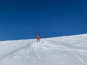
Minimal snowfall and light winds yesterday have decreased the concerns for wind slabs. Continue to look out for small wind slabs sitting on top of a slippery crust in isolated areas or in extreme terrain. Avalanche danger is LOW. Use caution in alpine terrain today as icy patches and overhead rime ice hazards exist.


Avalanche Problem 1: Wind Slab
-
Character ?

-
Aspect/Elevation ?
-
Likelihood ?CertainVery LikelyLikelyPossible
 Unlikely
 -
Size ?HistoricVery LargeLargeSmall

Three inches of snowfall and light winds were observed yesterday. Despite the availability of dry unconsolidated snow and expected stronger winds out of the northwest that could allow continued growth and distribution, wind slabs should remain small today. The main concern is that a small wind slab could catch an unaware skier off guard and take them into dangerous terrain or on a slide for life ride. A widespread and extremely slippery ice crust exist near and above treeline.
Forecast Discussion
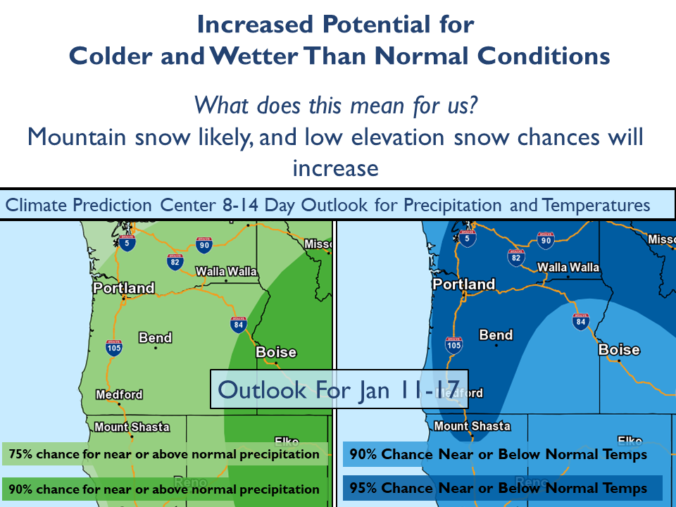
The National Weather Service (NWS) Climate Prediction Center (CPC) outlook shows an encouraging possibility of above normal precipitation and near or below normal temperatures from January 11th to 17th. Below is a map developed by the NWS forecast office in Medford, Oregon. For more information see the NWS Medford and Climate Prediction Center websites.
Recent Observations
In the last 24 hours on Mount Shasta:
- Temperatures have ranged from 19 to 25 degrees F at 8,000 feet.
- Wind speeds have averaged 13 mi/hr, gusting up to 25 mi/hr at 8,000 feet.
- The height of snow (HS) at 7,600 feet is 45 inches.
- 3 inches of new snow has been recorded
- Below treeline: A few inches of dry unconsolidated snow sits atop melt freeze crusts
- Near treeline: 2 to 3 inches (8-10 cm) of poorly bonded, low density snow exists on top of the 12/19 ice crust
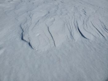
- Above treeline: Icy patches, small soft wind slabs 3 to 4 inches deep, and striated wind textured snow
- Small drifts 8 to 10 inches deep were observed on ridgelines
- No recent avalanches or obvious signs of instability have been observed.

Weather and Current Conditions
Weather Summary
Over the next 48 hours, expect mostly sunny, dry conditions and light to moderate winds out of the west/northwest. There is a slight chance of a quick snow shower rolling through the area this afternoon but don't blink or you'll miss it. Less than an inch of snow is possible with snow levels near town. Mostly clear skies will return tonight. A warmer day with mostly sunny skies is forecast for tomorrow.
Another quick moving storm with light snow showers is scheduled to arrive Tuesday morning. A few inches of snow is possible.
24 Hour Weather Station Data @ 5:00 AM
| Weather Station | Temp (°F) | Wind (mi/hr) | Snow (in) | Comments | ||||||||
|---|---|---|---|---|---|---|---|---|---|---|---|---|
| Cur | Min | Max | Avg | Avg | Max Gust | Dir | Depth | New | Water Equivalent | Settlement | ||
| Mt. Shasta City (3540 ft) | 33 | 30 | 38 | 34.5 | 1 | N | ||||||
| Sand Flat (6750 ft) | 25 | 23 | 32 | 26 | 39 | 3 | 0 | 0 | ||||
| Ski Bowl (7600 ft) | 21.5 | 21 | 28.5 | 24 | 44 | 3.1 | 0.09 | 0 | ||||
| Gray Butte (8000 ft) | 19.5 | 19 | 25 | 21.5 | 14 | 43 | NW | |||||
| Castle Lake (5870 ft) | 0 | 0 | 0 | 0 | 0 | 0 | 0 | down | ||||
| Mount Eddy (6509 ft) | 21.5 | 21.5 | 28 | 24.5 | 1 | 9 | SE | 34.3 | 1.3 | 1 | ||
| Ash Creek Bowl (7250 ft) | down | |||||||||||
| Ash Creek Ridge (7895 ft) | down |
Two Day Mountain Weather Forecast
Produced in partnership with the Medford NWS
| For 7000 ft to 9000 ft | |||
|---|---|---|---|
|
Sunday (4 a.m. to 10 p.m.) |
Sunday Night (10 p.m. to 4 a.m.) |
Monday (4 a.m. to 10 p.m.) |
|
| Weather | Mostly sunny. Increasing clouds in the afternoon. 40 percent chance of snow showers. | Mostly clear. | Mostly sunny. |
| Temperature (°F) | 32 | 24 | 39 |
| Wind (mi/hr) | West 5-10 | Northwest 5-10 | Northwest 5-10 |
| Precipitation SWE / Snowfall (in) | 0.01 / 0-0.50 | 0.00 / 0 | 0.00 / 0 |
| For 9000 ft to 11000 ft | |||
| Sunday | Sunday Night | Monday | |
| Weather | Mostly sunny. Increasing clouds in the afternoon. 40 percent chance of snow showers. | Mostly clear. | Sunny. |
| Temperature (°F) | 21 | 21 | 28 |
| Wind (mi/hr) | West 20-25 | Northwest 25-30 | Northwest 20-25 |
| Precipitation SWE / Snowfall (in) | 0.01 / 0 | 0.00 / 0 | 0.00 / 0 |
Season Precipitation for Mount Shasta City
| Period | Measured (in) | Normal (in) | Percent of Normal (%) |
|---|---|---|---|
| From Oct 1, 2025 (the wet season) | 9.23 | 16.15 | 57 |
| Month to Date (since Jul 1, 2026) | 0.30 | 0.94 | 32 |
| Year to Date (since Jan 1, 2026) | 0.30 | 0.94 | 32 |

