

You are here
Avalanche Forecast for 2020-01-06 06:45
- EXPIRED ON January 7, 2020 @ 6:45 amPublished on January 6, 2020 @ 6:45 am
- Issued by Ryan Sorenson - Mount Shasta Avalanche Center
Bottom Line
Triggering an avalanche is unlikely today due to warmer temperatures and light winds. Avalanche danger is LOW. Normal caution is advised. Continue to look out for lingering wind slabs on isolated terrain features especially in complex and extreme terrain. Use caution in alpine terrain today as icy patches and overhead rime ice hazards remain.


Avalanche Problem 1: Normal Caution
-
Character ?

-
Aspect/Elevation ?
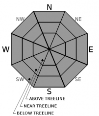
-
Likelihood ?CertainVery LikelyLikelyPossible
 Unlikely
 -
Size ?HistoricVery LargeLargeSmall

Triggering an avalanche remains unlikely today. Strong winds have stripped the tops of moraines and west facing slopes down to the 12/19 rain crust. Use caution as extremely icy patches exist. Little evidence of wind slabs have been observed lately. If you encounter them they will be small. Warm temperatures and light winds today will also lead to increased stability of any lingering wind slabs.
LOW avalanche danger does not mean no avalanche danger. Use normal caution while traveling in the backcountry today:
- Carry proper rescue equipment: beacon, shovel, probe.
- Focus on using safe travel techniques.
- Watch your partners as they move through avalanche terrain.
- Continue to look for isolated slabs/unstable snow and discuss the findings with your group.
- Have open communication and discuss whether or not it makes sense to commit to a slope.
- Try to regroup in safe areas out of avalanche paths.
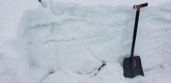
Recent Observations
In the last 24 hours on Mount Shasta:
- Temperatures have ranged from 17 to 30 degrees F at 8,000 feet.
- Wind speeds have averaged 20 mi/hr, gusting up to 49 mi/hr at 8,000 feet.
- The height of snow (HS) at 7,600 feet is 43 inches.
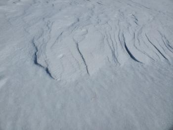
- Strong winds continued near and above treeline.
- Wind transported snow but wind loading was minimal. Very little evidence of wind slabs were observed.
- Snow surfaces below, near, and above treeline were variable. Wind buffed powder, sastrugi and a mix of icy patches were found on Mount Shasta.
- Protected gullies held 2 to 3 inches of wind buffed snow and provided the best chance for finding smooth skiing surfaces.
- No recent avalanches or obvious signs of instability have been observed.

Weather and Current Conditions
Weather Summary
Expect sunny, dry conditions and light winds out of the north/northwest today.
Clear skies this evening will become partly cloudy after 10 pm as another cold front begins to move onshore. The majority of this storm will pass the region to the north. The bulk of snow will fall on Tuesday evening after 4 pm. Light snow showers are expected to continue through Thursday morning. We will see one to three inches of total snowfall from this storm. Snow levels will start around 4,000 feet Tuesday then drop slightly to 3,500 feet on Wednesday.
24 Hour Weather Station Data @ 2:00 AM
| Weather Station | Temp (°F) | Wind (mi/hr) | Snow (in) | Comments | ||||||||
|---|---|---|---|---|---|---|---|---|---|---|---|---|
| Cur | Min | Max | Avg | Avg | Max Gust | Dir | Depth | New | Water Equivalent | Settlement | ||
| Mt. Shasta City (3540 ft) | 28 | 27 | 45 | 32.5 | 1 | N | ||||||
| Sand Flat (6750 ft) | 32 | 21 | 32 | 27 | 39 | 0 | 0 | 0 | ||||
| Ski Bowl (7600 ft) | 32 | 17.5 | 32 | 25.5 | 43.8 | 0 | 0 | 0 | ||||
| Gray Butte (8000 ft) | 29.5 | 17.5 | 30 | 23.5 | 20 | 49 | NW | |||||
| Castle Lake (5870 ft) | 0 | 0 | 0 | 0 | 0 | 0 | 0 | down | ||||
| Mount Eddy (6509 ft) | 26.5 | 21 | 28.5 | 24.5 | 1 | 9 | SE | 34.3 | 0 | 0 | ||
| Ash Creek Bowl (7250 ft) | down | |||||||||||
| Ash Creek Ridge (7895 ft) | down |
Two Day Mountain Weather Forecast
Produced in partnership with the Medford NWS
| For 7000 ft to 9000 ft | |||
|---|---|---|---|
|
Monday (4 a.m. to 10 p.m.) |
Monday Night (10 p.m. to 4 a.m.) |
Tuesday (4 a.m. to 10 p.m.) |
|
| Weather | Sunny. | Mostly clear increasing clouds after 10 pm. | Snow. A 80 percent chance of snow after 4pm. Snow levels near 4,200 feet. |
| Temperature (°F) | 38 | 28 | 26 |
| Wind (mi/hr) | North 0-5 | Southwest 5-10 | South 5-10 |
| Precipitation SWE / Snowfall (in) | 0.00 / 0 | 0.00 / 0 | 0.19 / 1-2 |
| For 9000 ft to 11000 ft | |||
| Monday | Monday Night | Tuesday | |
| Weather | Sunny. | Mostly clear. | Snow mainly after 4 pm. Windy. Wind chill values as low as -5 F. |
| Temperature (°F) | 28 | 26 | 28 |
| Wind (mi/hr) | Northwest 10-15 | West 15-20 | Southwest 20-25 |
| Precipitation SWE / Snowfall (in) | 0.00 / 0 | 0.00 / 0 | 0.19 / 1-3 |
Season Precipitation for Mount Shasta City
| Period | Measured (in) | Normal (in) | Percent of Normal (%) |
|---|---|---|---|
| From Oct 1, 2025 (the wet season) | 9.23 | 16.15 | 57 |
| Month to Date (since Jul 1, 2026) | 0.30 | 0.94 | 32 |
| Year to Date (since Jan 1, 2026) | 0.30 | 0.94 | 32 |

