

You are here
Avalanche Forecast for 2020-01-07 07:00
- EXPIRED ON January 8, 2020 @ 7:00 amPublished on January 7, 2020 @ 7:00 am
- Issued by Aaron Beverly - Mount Shasta Avalanche Center
Bottom Line
Though a dusting of new snow is expected tonight, avalanche danger will remain LOW. Be prepared for icy conditions if climbing onto steep slopes.


Avalanche Problem 1: Normal Caution
-
Character ?

-
Aspect/Elevation ?
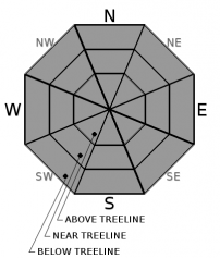
-
Likelihood ?CertainVery LikelyLikelyPossible
 Unlikely
 -
Size ?HistoricVery LargeLargeSmall

LOW avalanche danger does not mean no avalanche danger. Use normal caution while traveling in the backcountry today:
- Carry proper rescue equipment: beacon, shovel, probe.
- Use safe travel techniques.
- Look out for isolated slabs/unstable snow.
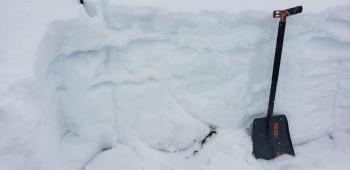
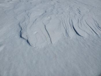
Recent Observations
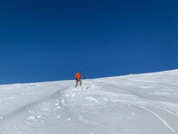
In the last 24 hours on Mount Shasta, temperatures have ranged from 28 to 40°F. Westerly winds were mostly light maxing out at 16 mi/hr.
Little change in conditions have been seen since yesterday. Expect icy snow surfaces, a crust breakable with boots, supportable on skis.
A bit of snow will be found in gullies and wind protected areas near and above treeline. Expect melt-freeze crusts below treeline due to warming temperatures and solar radiation.
The overall snowpack is stable. No signs of instabilities have been seen.
Weather and Current Conditions
Weather Summary
A smattering of snow is expected tonight, not more than an inch. Tomorrow, even less. Expect moderate southerly and westerly winds. Snow levels will be below 5,000 ft. Be prepared for cold temperatures.
Unsettled weather looks to come our way late Friday with a series of cold systems dropping in from the Gulf of Alaska. This could be accompanied with moderate to heavy snowfall. Stay tuned ....
24 Hour Weather Station Data @ 6:00 AM
| Weather Station | Temp (°F) | Wind (mi/hr) | Snow (in) | Comments | ||||||||
|---|---|---|---|---|---|---|---|---|---|---|---|---|
| Cur | Min | Max | Avg | Avg | Max Gust | Dir | Depth | New | Water Equivalent | Settlement | ||
| Mt. Shasta City (3540 ft) | 26 | 26 | 50 | 33.5 | 1 | N | ||||||
| Sand Flat (6750 ft) | 29 | 26 | 39 | 32 | 39 | 0 | 0 | 1 | ||||
| Ski Bowl (7600 ft) | 31.5 | 28.5 | 39.5 | 33.5 | 42.9 | 0 | 0 | 1 | ||||
| Gray Butte (8000 ft) | 30 | 28 | 36.5 | 32.5 | 11 | 25 | WNW | |||||
| Castle Lake (5870 ft) | down | |||||||||||
| Mount Eddy (6509 ft) | 34 | 26.5 | 38.5 | 33 | 2 | 5 | WSW | 34 | 0 | 1 | ||
| Ash Creek Bowl (7250 ft) | down | |||||||||||
| Ash Creek Ridge (7895 ft) | down |
Two Day Mountain Weather Forecast
Produced in partnership with the Medford NWS
| For 7000 ft to 9000 ft | |||
|---|---|---|---|
|
Tuesday (4 a.m. to 10 p.m.) |
Tuesday Night (10 p.m. to 4 a.m.) |
Wednesday (4 a.m. to 10 p.m.) |
|
| Weather | A 20 percent chance of snow after 1 p.m. Increasing clouds. | Snow showers. Chance of precipitation is 90%. | A chance of snow showers before 4 p.m., then snow likely after 4 p.m. Mostly cloudy. Chance of precipitation is 60%. |
| Temperature (°F) | 34 | 25 | 25 |
| Wind (mi/hr) | South 10-15 | Southwest 10-15 | West 5-10 |
| Precipitation SWE / Snowfall (in) | 0.00 / 0 | 0.07 / 0.50-1 | 0.01 / 0-0.50 |
| For 9000 ft to 11000 ft | |||
| Tuesday | Tuesday Night | Wednesday | |
| Weather | A 20 percent chance of snow after 1 p.m. Increasing clouds. Low wind chills. Windy and gusty. | Snow showers. Low wind chills. Blustery and gusty. Chance of precipitation is 80%. | A chance of snow showers before 4 p.m., then snow likely after 4 p.m. Mostly cloudy. Low wind chills. Windy and gusty. Chance of precipitation is 60%. |
| Temperature (°F) | 27 | 12 | 15 |
| Wind (mi/hr) | Southwest 20-25 | West 20-25 | Northwest 15-20 |
| Precipitation SWE / Snowfall (in) | 0.00 / 0 | 0.07 / 0.50-1.50 | 0.01 / 0-0.50 |
Season Precipitation for Mount Shasta City
| Period | Measured (in) | Normal (in) | Percent of Normal (%) |
|---|---|---|---|
| From Oct 1, 2025 (the wet season) | 9.23 | 16.62 | 56 |
| Month to Date (since Jul 1, 2026) | 0.30 | 1.41 | 21 |
| Year to Date (since Jan 1, 2026) | 0.30 | 1.41 | 21 |

