

You are here
Avalanche Forecast for 2020-01-08 06:00
- EXPIRED ON January 9, 2020 @ 6:00 amPublished on January 8, 2020 @ 6:00 am
- Issued by Aaron Beverly - Mount Shasta Avalanche Center
Bottom Line
Avalanche danger will be LOW for most of the day. A late night storm will bring new snow and moderate to strong westerly winds that will raise concern for wind slabs on steep, leeward terrain. Avalanche danger will rise to MODERATE by tomorrow morning.


Avalanche Problem 1: Wind Slab
-
Character ?

-
Aspect/Elevation ?
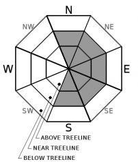
-
Likelihood ?CertainVery LikelyLikelyPossible
 Unlikely
 -
Size ?HistoricVery LargeLargeSmall

Avalanche danger will be LOW for most of the day. Tonight, up to 5 inches of snow could fall. Southwest and west winds will be moderate to strong. These speeds and directions tend to be very productive in producing wind slabs. Widespread crusts will offer a smooth bedsurface for these slabs to slide on. Cold temperatures will prevent a good bond between new and old snow. Avalanche danger will rise to MODERATE by tomorrow morning. Human-triggered avalanches will be possible on steep leeward terrain.
If you encounter shooting cracks, blocking, whumphing, scoured areas, or wind drifts, wind slabs might be nearby. Be extra careful when entering terrain greater than 35 degrees.
Forecast Discussion
It is debatable how dangerous the icy, exposed crust is out there. It seems to be more of a hazard to skiers than to boot packers. It breaks under foot into a layer of soft snow. Climbers should prepare for a Sisyphean boot pack if attempting a summit. The crust is supportable to skis and those skinning up might encounter frustrating moments of skis sliding out from under them. Either way, be prepared for icy conditions. Bring an ice axe and crampons if ascending into steep terrain.
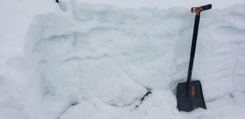
Recent Observations
In the last 24 hours on Mount Shasta, temperatures have ranged from 35 to 21°F. Westerly winds were light to moderate maxing out at 21 mi/hr.
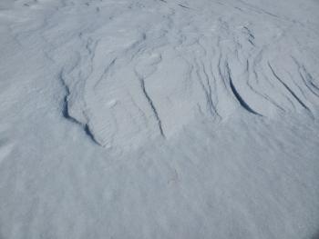
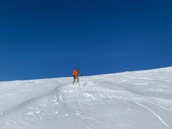
Near and above treeline on Mount Shasta, expect slick conditions. Wind has scoured much of the snowpack down to an icy crust that is breakable by boots, supportable on skis. Wind sheltered areas still hold a couple of inches of low density snow.
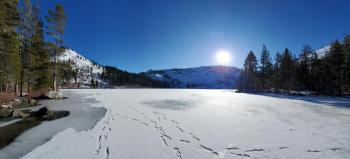
Castle Lake is frozen. A widespread crust dominates the snow surface on all peaks. Snow depth is 25 in (65 cm).
South Fork Road is icy but drivable to the bridge crossing to Gray Rock Lakes.
The overall snowpack is stable. No signs of instabilities have been seen.
Weather and Current Conditions
Weather Summary
The forecast is looking much more positive today, presuming more snow is a positive outlook for you. It is for us. A winter weather advisory is in effect from 9 p.m. this evening to 6 a.m. Thursday.
Somewhere between 2 to 6 inches of snow should fall with more snow expected at higher elevations. Most of this will come late tonight. Snow levels will drop from 3,700 ft to as low as 2,500 ft. Dunsmuir is likely to see snow by tomorrow.
Southwest and west winds will be moderate to strong during this storm.
A series of systems will drop in from the Gulf of Alaska on Friday bringing low snow levels and significant snow through the weekend.
24 Hour Weather Station Data @ 5:00 AM
| Weather Station | Temp (°F) | Wind (mi/hr) | Snow (in) | Comments | ||||||||
|---|---|---|---|---|---|---|---|---|---|---|---|---|
| Cur | Min | Max | Avg | Avg | Max Gust | Dir | Depth | New | Water Equivalent | Settlement | ||
| Mt. Shasta City (3540 ft) | 34 | 24 | 46 | 36 | 1 | N | ||||||
| Sand Flat (6750 ft) | 25 | 25 | 37 | 30 | 38 | 0 | 0 | 2 | ||||
| Ski Bowl (7600 ft) | 21 | 21 | 34.5 | 27 | 43.3 | 0 | 0.01 | 3.5 | ||||
| Gray Butte (8000 ft) | 20 | 20 | 32.5 | 25 | 15 | 31 | WNW | |||||
| Castle Lake (5870 ft) | down | |||||||||||
| Mount Eddy (6509 ft) | 23.5 | 22.5 | 36.5 | 29 | 1 | 9 | SSE | 34.1 | 0 | 2.5 | ||
| Ash Creek Bowl (7250 ft) | down | |||||||||||
| Ash Creek Ridge (7895 ft) | down |
Two Day Mountain Weather Forecast
Produced in partnership with the Medford NWS
| For 7000 ft to 9000 ft | |||
|---|---|---|---|
|
Wednesday (4 a.m. to 10 p.m.) |
Wednesday Night (10 p.m. to 4 a.m.) |
Thursday (4 a.m. to 10 p.m.) |
|
| Weather | Snow showers likely before 4 p.m., then snow after 4 p.m. Chance of precipitation is 80%. | Snow. Chance of precipitation is 100%. | Snow showers, mainly before 10 a.m. Blustery. Chance of precipitation is 80%. |
| Temperature (°F) | 28 | 23 | 26 |
| Wind (mi/hr) | Southwest 10-15 | Southwest 5-10 | Northwest 5-10 |
| Precipitation SWE / Snowfall (in) | 0.06 / 0-1 | 0.30 / 1-3 | 0.07 / 0-1 |
| For 9000 ft to 11000 ft | |||
| Wednesday | Wednesday Night | Thursday | |
| Weather | Snow showers likely before 4 p.m., then snow after 4 p.m. Windy and gusty. Low wind chills. Chance of precipitation is 80%. | Snow. Windy and gusty. Low wind chills. Chance of precipitation is 100%. | Snow showers, mainly before 10 a.m. Windy and gusty. Low wind chills. Chance of precipitation is 80%. |
| Temperature (°F) | 16 | 12 | 23 |
| Wind (mi/hr) | West 30-35 | West 20-25 | North 25-30 |
| Precipitation SWE / Snowfall (in) | 0.06 / 0-1 | 0.30 / 3-5 | 0.07 / 0-1 |
Season Precipitation for Mount Shasta City
| Period | Measured (in) | Normal (in) | Percent of Normal (%) |
|---|---|---|---|
| From Oct 1, 2025 (the wet season) | 9.23 | 16.86 | 55 |
| Month to Date (since Jul 1, 2026) | 0.30 | 1.65 | 18 |
| Year to Date (since Jan 1, 2026) | 0.30 | 1.65 | 18 |

