

You are here
Avalanche Forecast for 2020-01-12 06:45
- EXPIRED ON January 13, 2020 @ 6:45 amPublished on January 12, 2020 @ 6:45 am
- Issued by Ryan Sorenson - Mount Shasta Avalanche Center
Bottom Line
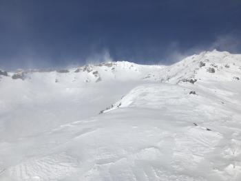
Though a dusting of new snow is expected today, avalanche danger is LOW. Much of the snow available for transport has been stripped away. Natural and human triggered avalanches are unlikely, but new, small wind slabs may form on isolated or extreme terrain near and above treeline. Strong westerly winds will continue to blow today.


Avalanche Problem 1: Wind Slab
-
Character ?

-
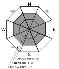
Aspect/Elevation ?
-
Likelihood ?CertainVery LikelyLikelyPossible
 Unlikely
 -
Size ?HistoricVery LargeLargeSmall

Little snow accumulation was observed yesterday. Existing wind slabs remain difficult to trigger. Much of the snow available for transport has been stripped away. Watch for small, new wind slabs in isolated areas, extreme terrain, or small pockets in protected steep couloirs.
Remember, low danger does not mean no danger. Carry a beacon, shovel, and probe and know how to use them. Focus on using safe travel techniques. Create a travel plan, stick to your travel plan, actively look for evidence of instability while on the snow, communicate well within your group, and expose only one person at a time to avalanche terrain.
Forecast Discussion
Expect higher, wind exposed terrain is to be very firm, extremely icy and dangerous.
Recent Observations
Windy and cold conditions were felt on the mountain yesterday. Most of the available snow has been hard packed or blown from the upper elevations.
In the last 24 hours on Mount Shasta:
- Temperatures have ranged from 15 to 21 degrees F at 8,000 feet.
- Strong wind speeds have averaged 25 mi/hr, gusting up to 55 mi/hr at 8,000 feet.
- The height of snow (HS) at 7,600 feet is 47 inches.
- Existing snow surfaces:
- Below Treeline: Low density snow, 4 to 7 inches deep, can still be found in protected area. Open areas are beginning to show signs of wind affect.
- Near Treeline: Wind affect becomes more noticeable. Westerly aspects and ridges are scoured. Small drifts 8 to 10 inches deep were observed on east facing ridgelines.
- Above Treeline: Windy, scoured to the 12/19 ice layer. Variable wind crusts, sastrugi, scoured, and hard snow surfaces exist above treeline.
Weather and Current Conditions
Weather Summary
The steady flow of stormy weather will continue today. Though the major impact of this storm will miss the area to the north, expect a gradual increase of snow showers after 10 a.m. Accumulation of 1 to 3 inches of snow is possible with snow levels near 3,000 feet.
Snow will taper off after 10 p.m. this evening as another short break in the action settles in. The next wave of stormy weather will arrive around noon tomorrow. A more southerly flow is forecast with this one as warmer, moist air pushes in around a low pressure system. Snow levels will rise to around 3,500 feet then will drop tomorrow night. Snow accumulation of 2 to 5 inches is possible.
24 Hour Weather Station Data @ 5:00 AM
| Weather Station | Temp (°F) | Wind (mi/hr) | Snow (in) | Comments | ||||||||
|---|---|---|---|---|---|---|---|---|---|---|---|---|
| Cur | Min | Max | Avg | Avg | Max Gust | Dir | Depth | New | Water Equivalent | Settlement | ||
| Mt. Shasta City (3540 ft) | 25 | 25 | 44 | 33.5 | 2 | N | ||||||
| Sand Flat (6750 ft) | 23 | 19 | 27 | 24 | 41 | 0 | 0 | 0 | ||||
| Ski Bowl (7600 ft) | 21.5 | 14.5 | 25.5 | 20.5 | 47.6 | 0 | 0.01 | 0 | ||||
| Gray Butte (8000 ft) | 17 | 15.5 | 21.5 | 18.5 | 25 | 61 | NW | |||||
| Castle Lake (5870 ft) | down | |||||||||||
| Mount Eddy (6509 ft) | 22 | 16.5 | 27 | 22.5 | 3 | 14 | SE | 35.6 | 0 | 0 | ||
| Ash Creek Bowl (7250 ft) | down | |||||||||||
| Ash Creek Ridge (7895 ft) | down |
Two Day Mountain Weather Forecast
Produced in partnership with the Medford NWS
| For 7000 ft to 9000 ft | |||
|---|---|---|---|
|
Sunday (4 a.m. to 10 p.m.) |
Sunday Night (10 p.m. to 4 a.m.) |
Monday (4 a.m. to 10 p.m.) |
|
| Weather | Chance of snow this morning, then snow after 10 a.m. Blustery. Snow levels near 3,000 feet. | A chance of snow showers, mostly cloudy. Snow levels near 3,000 feet | Snow. Partly cloudy then becoming mostly cloudy. |
| Temperature (°F) | 26 | 21 | 27 |
| Wind (mi/hr) | Southwest 10-15 | West 10-15 | Southwest 10-15 |
| Precipitation SWE / Snowfall (in) | 0.16 / 1-3 | 0.00 / 0-2 | 0.37 / 2-5 |
| For 9000 ft to 11000 ft | |||
| Sunday | Sunday Night | Monday | |
| Weather | Chance of snow before 10 a.m., then snow showers likely. Widespread blowing snow. Windy. Wind chill values near -20 F. | Breezy. Chance of snow in the evening, then snow showers likely after midnight. Wind chill values near -23 F. | Snow, mainly after 11 a.m. Windy. Wind chill values near -21 F. |
| Temperature (°F) | 13 | 11 | 17 |
| Wind (mi/hr) | West 30-40 | West 30-40 | West 30-40 |
| Precipitation SWE / Snowfall (in) | 0.16 / 1-3 | 0.00 / 0-2 | 0.37 / 2-4 |
Season Precipitation for Mount Shasta City
| Period | Measured (in) | Normal (in) | Percent of Normal (%) |
|---|---|---|---|
| From Oct 1, 2025 (the wet season) | 9.36 | 17.85 | 52 |
| Month to Date (since Jul 1, 2026) | 0.43 | 2.64 | 16 |
| Year to Date (since Jan 1, 2026) | 0.43 | 2.64 | 16 |

