

You are here
Avalanche Forecast for 2020-01-16 06:52
- EXPIRED ON January 17, 2020 @ 6:52 amPublished on January 16, 2020 @ 6:52 am
- Issued by Nick Meyers - Shasta-Trinity National Forest
Bottom Line
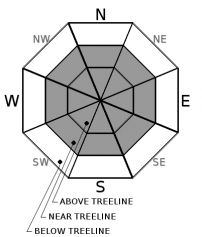
A strong winter storm is currently impacting the forecast area. Several different avalanche problems will necessitate thoughtful terrain choice today. Expect HIGH avalanche danger above and near treeline and CONSIDERABLE danger below treeline.


Avalanche Problem 1: Wind Slab
-
Character ?

-
Aspect/Elevation ?
-
Likelihood ?CertainVery LikelyLikelyPossible
 Unlikely
 -
Size ?HistoricVery LargeLargeSmall

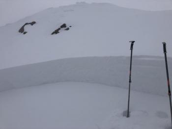
Wind slabs were very touchy and easily triggered by human weight yesterday, near and above treeline. Moderate winds have blown primarily out of the west/southwest, switching to southeast late last night. Drifts have been observed up to several feet thick. Unstable wind slabs and cornice features will lurk near and above treeline along ridgelines, near the tops of bowls and along steeper moraine features. Look for wind slabs on all aspects. Mount Shasta can create funky wind eddies and one could observe wind blowing from many directions. Pay attention to warning signs like shooting cracks, blocking, whumphing, scoured areas, or wind drifts as wind slabs might be nearby. Be extra careful when entering terrain greater than 35 degrees.
Avalanche Problem 2: Storm Slab
-
Character ?

-
Aspect/Elevation ?
-
Likelihood ?CertainVery LikelyLikelyPossible
Unlikely
-
Size ?HistoricVery LargeLargeSmall
Storm slabs are likely today on steep slopes where new snowfall is greater than 6 inches and a cohesive slab exists. Storm slab instabilities typically last only a few hours in our snow climate. Likelihood for triggering a storm slab will be best immediately during or just after our current storm in progress. All aspects below treeline and protected areas near treeline will host the best chance for a storm slab avalanche.
Avalanche Problem 3: Persistent Slab
-
Character ?

-
Aspect/Elevation ?

-
Likelihood ?CertainVery LikelyLikelyPossible
Unlikely
-
Size ?HistoricVery LargeLargeSmall
Weak, sugary snow has been observed above the 12/19 ice layer in many portions of the forecast area including Parks Creek summit in the Eddies, Gumboot and Castle Lake areas, the base of Gray Butte and also near the Horse Camp cabin. Stability tests have yielded poor (unstable) to good (stable) results, indicating a lot of spatial variability in the layers tolerance for load. It's important to mention with this avalanche problem that snowpack tests should NOT result in a "go" or "no go" decision. They are only a very small data point in a larger assessment. It is dangerous to conclude that a problem is absent or unreactive based on one simple test. Persistent weak layers (PWL's) are tricky and we don't have much experience dealing with them in our snow climate! The bottom line is that we have observed this weak layer of snow lurking down in the snowpack for over a week. A significant load is now on top. We arrive at a low likelihood/high-consequence situation. Don't expect this problem to announce its presence. Shooting cracks and recent avalanche activity are generally not observed. PWL's can often awake during periods of intense loading.
Put a sufficiently large physical margin between you and any suspect slopes. Terrain is your friend, enjoy the soft snow on lower angle slopes with no overhead hazard.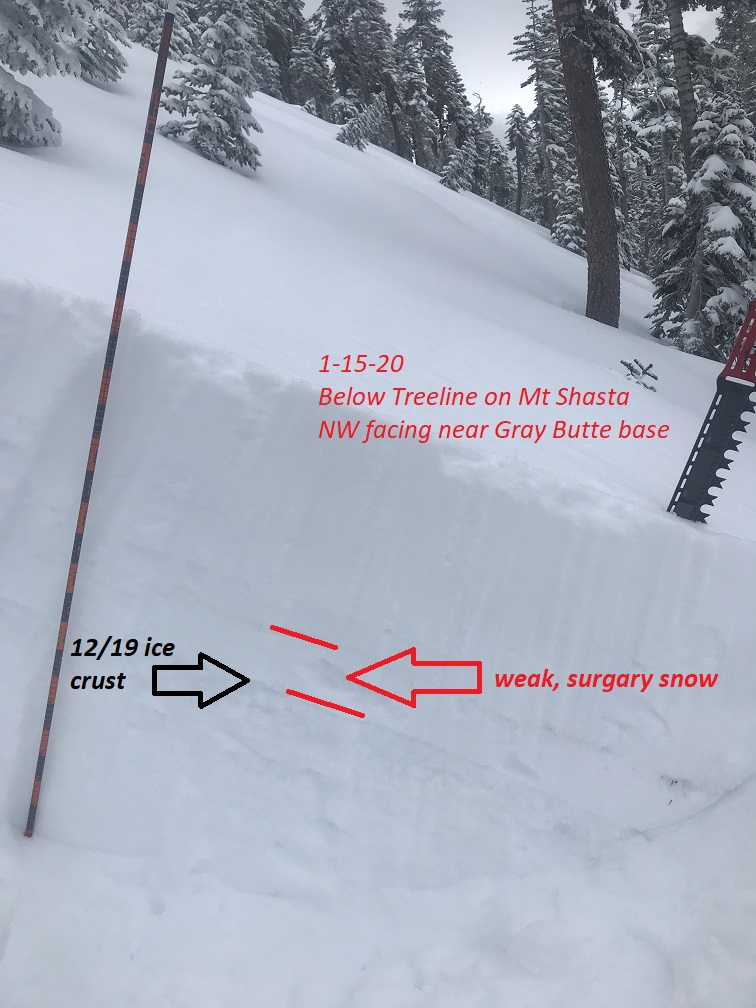
Forecast Discussion
Today will host the highest avalanche danger we've seen all season. All the signs are there: wind, significant snow, recent activity and a persistent weak layer in there to boot. We're on our toes monitoring it all and providing the best possible information. Be safe out there powder hounds.
Recent Observations
In the last 24 hours:
- Mount Shasta
- 5-7 inches of new snow has fallen as of this morning at 0500. South/southwest wind switching to southeast at 1800 hours has averaged 10 mi/hr with gusts to 31 mi/hr on Gray Butte, 8,000 feet.
- Exposed, windward terrain above treeline remains scoured, however wind loading was very active yesterday. Wind slabs on small test slopes were easily triggered by human weight on leeward, easterly aspects. Below treeline in several areas, a 1 to 2 inch thick, sugary layer of snow was observed below a thin crust, 7-12 inches down from the snow surface. This layer is synonymous with what we've seen in other portions of the forecast area and rests just above the 12/19 ice layer. New snow rests on top of this weak, sugary snow.
- Castle Lake
- Weak, sugary snow remains above the 12/19 ice crust with up to 14 inches of fist hard snow on top. Wind drifts observed up to 2 feet deep. Plenty of wind transporting snow
- Weak, sugary snow remains above the 12/19 ice crust with up to 14 inches of fist hard snow on top. Wind drifts observed up to 2 feet deep. Plenty of wind transporting snow
- Eddy Range
- West of I-5, about 17 inches of low density snow dominates the surface. Total depth is about 55 inches. Instabilities in the snowpack were observed 2 days ago. Column and block tests yielded notable failures (CT2x2 SP ↓ 35 cm, ECTP12 SP ↓ 35 cm). Failures occurred below a razor thin sun crust atop sugary snow. The underlying snowpack is a mix of breakable crusts and sugary snow. On ridgelines, steady, light southwest winds were forming cornices and loading the top portion of slopes. Cornices and winds slabs were still small and stubborn to trigger, though blocking and cracking were seen.
Weather and Current Conditions
Weather Summary
Heavy precipitation commenced last night and is ongoing this morning. The front will continue to move eastward and things will become more showery today. Winds will be gusty and breezy in the usual spots, near and above treeline. The winds will begin to die off this afternoon, as will precipitation.
A brief break is expected Friday before the next storm moves through the area on Friday night into Saturday. This front will be much weaker than what we are currently experiencing.
24 Hour Weather Station Data @ 4:00 AM
| Weather Station | Temp (°F) | Wind (mi/hr) | Snow (in) | Comments | ||||||||
|---|---|---|---|---|---|---|---|---|---|---|---|---|
| Cur | Min | Max | Avg | Avg | Max Gust | Dir | Depth | New | Water Equivalent | Settlement | ||
| Mt. Shasta City (3540 ft) | 31 | 26 | 33 | 31.5 | 4 | |||||||
| Sand Flat (6750 ft) | 22 | 17 | 23 | 21 | 43 | 1 | 0 | 0 | ||||
| Ski Bowl (7600 ft) | 18 | 11 | 18.5 | 15.5 | 56.1 | 6.4 | 0.6 | 0 | ||||
| Gray Butte (8000 ft) | 17.5 | 12.5 | 17.5 | 15 | 10 | 31 | SSE | |||||
| Castle Lake (5870 ft) | 0 | 0 | 0 | 0 | 0 | 0 | 0 | down | ||||
| Mount Eddy (6509 ft) | 22 | 15 | 22 | 19 | 3 | 17 | SSW | 44.1 | 1 | 0 | ||
| Ash Creek Bowl (7250 ft) | down | |||||||||||
| Ash Creek Ridge (7895 ft) | down |
Two Day Mountain Weather Forecast
Produced in partnership with the Medford NWS
| For 7000 ft to 9000 ft | |||
|---|---|---|---|
|
Thursday (4 a.m. to 10 p.m.) |
Thursday Night (10 p.m. to 4 a.m.) |
Friday (4 a.m. to 10 p.m.) |
|
| Weather | Snow showers, snow heavy at times. Breezy. Chance of precip 100%. Snow levels to town or lower. | Snow showers, mainly before 10pm. Chance of precipitation 80%. Snow levels to town or lower. | Mostly cloudy with a 40% chance of snow showers. Snow level near town or lower. |
| Temperature (°F) | 25 | 24 | 16 |
| Wind (mi/hr) | South 10-15 | Southwest 5-10 | South 5-10 |
| Precipitation SWE / Snowfall (in) | 1.06 / 10-14 | 0.00 / 1-3 | 0.01 / 0-1 |
| For 9000 ft to 11000 ft | |||
| Thursday | Thursday Night | Friday | |
| Weather | Snow showers, snow heavy at times. Windy, with wind chill chill values near -23 F. Chance of precip 100%. | Snow showers, mainly before 10pm. Windy, with wind chill values near -27F. Chance of precip 80%. | Mostly cloudy, windy. Wind chill values near -24 F. |
| Temperature (°F) | 10 | 2 | 17 |
| Wind (mi/hr) | Southwest 35-45 | West 20-30 | West 15-25 |
| Precipitation SWE / Snowfall (in) | 1.06 / 11-17 | 0.00 / 1-2 | 0.01 / 0-1 |
Season Precipitation for Mount Shasta City
| Period | Measured (in) | Normal (in) | Percent of Normal (%) |
|---|---|---|---|
| From Oct 1, 2025 (the wet season) | 9.92 | 18.81 | 53 |
| Month to Date (since Jul 1, 2026) | 0.99 | 3.60 | 28 |
| Year to Date (since Jan 1, 2026) | 0.99 | 3.60 | 28 |

