

You are here
Avalanche Forecast for 2020-01-17 06:47
- EXPIRED ON January 18, 2020 @ 6:47 amPublished on January 17, 2020 @ 6:47 am
- Issued by Nick Meyers - Shasta-Trinity National Forest
Bottom Line
Red flags of avalanche danger were flying high yesterday due to a rapid loading event. While it's common for the snowpack to stabilize quickly in our maritime snow climate, we think best practice is to wait another day (or two) for things to settle out.
Westerly wind will kick up today causing concern for continued wind loading on easterly aspects. We're not in the clear yet and observations have been limited. Conservative terrain choice and cautious decision making is advised.


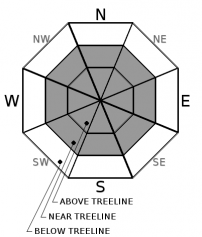
Avalanche Problem 1: Wind Slab
-
Character ?

-
Aspect/Elevation ?
-
Likelihood ?CertainVery LikelyLikelyPossible
 Unlikely
 -
Size ?HistoricVery LargeLargeSmall

Westerly winds have been productive in moving snow around and lord knows there is quite a pile of new snow still available for wind transport. West/Southwest wind is forecast to blow 20-30 mi/hr above treeline today. We do not have any recent observations from above treeline due to poor visibility/access. Near treeline on Gray Butte yesterday afternoon, shooting cracks in small wind slabs was observed and very touchy cornices were easily triggered. Expect similar conditions today. Wind slabs are confined to lee and cross-loaded terrain features and can be avoided by sticking to sheltered or wind-scoured areas. Wind slabs form in specific areas. Learn to recognize their characteristic shape and texture. They usually stabilize in less than a week, so wait several days after a big loading event. Mount Shasta sticks out 7,000 feet higher than any other piece of terrain in the area and can create very funky winds....such that the primary wind direction might be west, but you could observe wind from the opposite direction depending on your location on the mountain. Thus, we often included 'all aspects' for wind slab distribution.
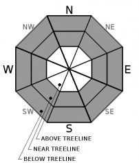
Avalanche Problem 2: Storm Slab
-
Character ?

-
Aspect/Elevation ?
-
Likelihood ?CertainVery LikelyLikelyPossible
Unlikely
-
Size ?HistoricVery LargeLargeSmall
Soft, storm slabs 5-7 inches deep were easily triggered and fully propagating across small test slope convexities yesterday, as well as the east face Gray Butte whopper that stepped down and took all the storm snow with it. Storm slabs often stabilize quickly but we think it's prudent to take another day of caution. Below and near treeline on all aspects is where you'll find this avalanche problem. Storm slabs are often hard to recognize since the surface is usually soft and powdery...just how we like it! Tilt tests, ski cut results on small inconsequential slopes or natural activity on indicator slopes are often the best clues this problem exists.
You'll hear often, "Oh, we are going to just ski in the trees...". This attitude won't keep you safe from this avalanche problem. You can avoid wind slabs with such behavior, but not storm slabs. If the trees are wide enough to ski through, an avalanche is possible. Reduce your risk by waiting several days after a big loading event...like the one we just had!
Avalanche Problem 3: Persistent Slab
-
Character ?

-
Aspect/Elevation ?

-
Likelihood ?CertainVery LikelyLikelyPossible
Unlikely
-
Size ?HistoricVery LargeLargeSmall
Yesterday's storm slab off the east bowl of Gray Butte did not fail on the persistent weak layer we've been monitoring. That said, snowpits continue to reveal layers of weak, faceted snow, now several feet deep in the snowpack. Column tests have been widely variable. The weakest structure has been observed west of I-5. To say the least, uncertainty exists in the likelihood for triggering a large avalanche on this persistent weak layer. This layer is now buried by upwards of 2 to 4 feet of snow. As the layer becomes more deeply buried, the weak layer often becomes harder to trigger--but the expected size of the avalanche can increase. This is that low likelihood/high-consequence situation, which is a challenge to our patience and decision making. So, we wait for the layer itself to get stronger. It will be up to you to dig in the snowpack and gauge it's strength using tools like snow profiles and snowpack tests. You can and you should do this. It's important to mention with this avalanche problem that snowpack tests should NOT result in a "go" or "no go" decision. They are only a very small data point in a larger assessment. Overall caution is advised when dealing with persistent slab avalanches as they are difficult to forecast and often exist in isolated or specific terrain features. Continuous and wide-reaching snowpack assessment is key to determining a weak layers distribution and reactivity.
Forecast Discussion
Unless you saddled up your snowmobile, the Mt Shasta Ski Park and Gray Butte was the only game in town for ski and board recreation yesterday due to closed access roads to Bunny Flat and Castle Lake areas. These roads likely remain closed this morning. Check our Instagram and/or Facebook feeds for the latest updates. We post as soon as we are informed.
Recent Observations
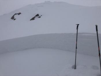
Yesterday was a stormy one. The Everitt Memorial Highway was closed (and likely remains closed this morning) and visibility was poor. Nearly constant snowfall accumulated rapidly over a short period of time and red flags of avalanche danger were numerous. This prompted some very conservative decision making throughout the day.
- For the storm beginning at 2200 hours on 1-15 and ending on 1-17 at 0100
- Old Ski Bowl weather station reported 18 inches, however observations on Gray Butte found an average of 20 to 30 inches over a 27 hour period.
- 1.74 inches of Snow/Water Equivalent (SWE)
- Westerly wind averaged 14 mi/hr with gusts to 37 mi/hr
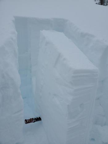
- A large D2 storm slab avalanche occurred on the east facing bowl off the top of Gray Butte. Crown: 2 feet / Width: 600+ feet
Click here for photos and observation - Below treeline, soft storm slabs 5-7 inches deep were easily triggered on steep convexities.
- Numerous whoomphing sounds (collapse in the snowpack) were heard during ascent up the south side of Gray Butte, below and near treeline
- Shooting cracks were easily initiated in wind slabs
- Cornice formation was active and cornices were easily triggered
- Wind blowing snow observed near and above treeline. Easterly aspects wind loading.
Weather and Current Conditions
Weather Summary
Light and localized showers will linger today, petering out by this evening. Snow levels will lie near 1,500 feet this morning, rising to 2,500 feet this afternoon.
Another weak front arrives Saturday bringing light precipitation. Windy conditions over higher terrain will push in ahead of the front. Meager water amounts are expected from Saturdays spurt. Snow levels will rise to 5,000 feet.
Longer term, the active pattern we've been in will continue next week. Northwesterly flow will shift and become more west/southwesterly. Several disturbances of Pacific origin will develop along the eastern extension of a strong west-central Pacific jet that stretches from Japan to north of Hawaii. Precipitation is certain, however snow levels are expected to be higher than we've had in the past few weeks.
24 Hour Weather Station Data @ 3:00 AM
| Weather Station | Temp (°F) | Wind (mi/hr) | Snow (in) | Comments | ||||||||
|---|---|---|---|---|---|---|---|---|---|---|---|---|
| Cur | Min | Max | Avg | Avg | Max Gust | Dir | Depth | New | Water Equivalent | Settlement | ||
| Mt. Shasta City (3540 ft) | 31 | 26 | 33 | 31.5 | 4 | |||||||
| Sand Flat (6750 ft) | 15 | 15 | 24 | 21 | 59 | 17 | 1 | |||||
| Ski Bowl (7600 ft) | 12.5 | 12.5 | 19 | 17 | 70.7 | 17 | 1.33 | 1.8 | ||||
| Gray Butte (8000 ft) | 12.5 | 12 | 19 | 16 | 14 | 37 | WSW | |||||
| Castle Lake (5870 ft) | 0 | 0 | 0 | 0 | 0 | 0 | 0 | down | ||||
| Mount Eddy (6509 ft) | 15.5 | 15 | 25 | 20.5 | 1 | 16 | SW | 59.3 | 15 | 1 | ||
| Ash Creek Bowl (7250 ft) | down | |||||||||||
| Ash Creek Ridge (7895 ft) | down |
Two Day Mountain Weather Forecast
Produced in partnership with the Medford NWS
| For 7000 ft to 9000 ft | |||
|---|---|---|---|
|
Friday (4 a.m. to 10 p.m.) |
Friday Night (10 p.m. to 4 a.m.) |
Saturday (4 a.m. to 10 p.m.) |
|
| Weather | Mostly cloudy with a 40% of snow showers. Snow levels near 1,000 to 1,500 feet this morning rising to 2,000 to 2,500 feet during the day. | Mostly cloudy with a 30% chance of snow showers. Snow levels near 2,000 to 2,500 feet. | Partly cloudy in the morning, then becoming mostly cloudy. A 50% chance of snow. Snow levels rising from 2,500 feet to 5,000 to 6,000 feet by the afternoon. |
| Temperature (°F) | 22 | 21 | 32 |
| Wind (mi/hr) | Southwest 10-15 | South 15-20 | South 10-15 |
| Precipitation SWE / Snowfall (in) | 0.01 / 0-1 | 0.00 / 0-0.50 | 0.05 / 0-0.50 |
| For 9000 ft to 11000 ft | |||
| Friday | Friday Night | Saturday | |
| Weather | Mostly cloudy. A 40% chance of snow showers, windy. | Mostly cloudy and windy. A 30% chance of snow showers, mainly before 10pm. | Partly cloudy, windy. A 40% chance of snow. |
| Temperature (°F) | 18 | 15 | 23 |
| Wind (mi/hr) | West 25-35 | Southwest 25-35 | West 25-35 |
| Precipitation SWE / Snowfall (in) | 0.01 / 0-1 | 0.00 / 0-0.50 | 0.05 / 0-0.50 |
Season Precipitation for Mount Shasta City
| Period | Measured (in) | Normal (in) | Percent of Normal (%) |
|---|---|---|---|
| From Oct 1, 2025 (the wet season) | 9.99 | 19.04 | 52 |
| Month to Date (since Jul 1, 2026) | 1.06 | 3.83 | 28 |
| Year to Date (since Jan 1, 2026) | 1.06 | 3.83 | 28 |

