

You are here
Avalanche Forecast for 2020-01-18 06:30
- EXPIRED ON January 19, 2020 @ 6:30 amPublished on January 18, 2020 @ 6:30 am
- Issued by Aaron Beverly - Mount Shasta Avalanche Center
Bottom Line
Avalanche danger will be MODERATE today due to the continued growth of wind slabs from existing snow. Though avalanche danger is on the decline, outlier regions such as the Eddies and Ash Creek Butte may see prolonged instabilities. A weak layer continues to linger deep within the snowpack near and below treeline. Evaluate the snowpack carefully if traveling near steep terrain.


Avalanche Problem 1: Wind Slab
-
Character ?

-
Aspect/Elevation ?
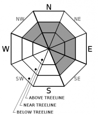
-
Likelihood ?CertainVery LikelyLikelyPossible
 Unlikely
 -
Size ?HistoricVery LargeLargeSmall

The concern for wind slabs is on the decline. Not much evidence of them was encountered yesterday in the Old Ski Bowl and on Gray Butte. Strong west winds above treeline today, though, could continue to load easterly slopes. Outlier regions, such as the Eddies and Ash Creek Butte, which tend to remain cold and see prolonged instabilities could still host wind slab problems.
Shooting cracks, blocking, hollow sounding snow, wind drifts, and wind scoured areas indicate wind slabs may be nearby.
Avalanche Problem 2: Deep Slab
-
Character ?

-
Aspect/Elevation ?
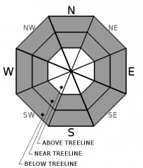
-
Likelihood ?CertainVery LikelyLikelyPossible
Unlikely
-
Size ?HistoricVery LargeLargeSmall
Tests indicate a deep instability in the snowpack with a weak layer above and below a rotten crust a little more than 100 cm down. It is hard to say how much force or weight could trigger a failure in these layers. Deep slab avalanches are particularly difficult to forecast. Signs of failures within this deep layer have not been seen with the weight of snow from the recent storm.
Persistent, deep-slabs are typically hard to trigger, are very destructive and dangerous due to the large mass of snow involved. They are often triggered from areas where the snow is shallow and weak. They are low likelihood, high consequence events.
Typical column tests will not trigger failures deep in the snow pack. Deep tap tests and propagating saw tests should be used when evaluating this hazard. Combine these observations with visual clues, good terrain choices, and the 5 red flags of avalanche danger.
Forecast Discussion
Come support your local avalanche center and have a blast doing so. First, join us for the festive 7th Annual Shasta Ascension Backcountry Race at the Mount Shasta Ski Park. The fun continues in the evening with the 18th Annual Snow Bowl. It is a true mountain party and one of the most fun events of the year! All ages are welcome.
Recent Observations
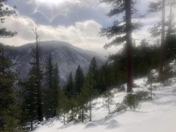
In the last 24 hours on Mount Shasta no discernible snow has been received. Temperatures have ranged from 11 to 21 degrees. West winds have averaged 11 mi/hr, maxing out at 16. Everitt Memorial Highway and Castle Lake Road are closed. Expect deep, low density snow above treeline.
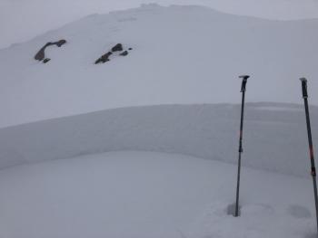
Observations on Gray Butte and the Old Ski Bowl indicate a stablizing snowpack. No notable cracking or blocking was seen, though in some places, wind drifted snow still sounds hollow. Ski cuts on wind drifts, cornices, and rollovers yielded no results. No new avalanches have been seen and no avalanches above treeline in Sun Bowl, Powder Bowl, or the Old Ski Bowl were observed, though the upper mountain only briefly revealed itself. Column and block tests yielded no notable results within the new storm snow.
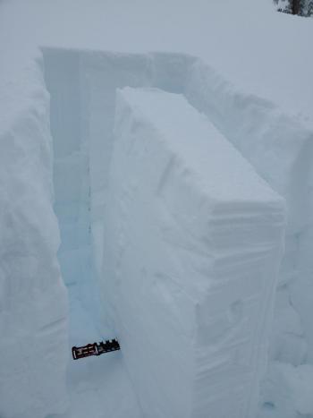
A deep, weak layer still persists just below 100 cm near and below treeline and tests showed disconcerting results. The weak layer resides near a rotten crust, above and below in unbonded granular snow. A propagating saw test resulted in end-to-end column failure at less than 30% of the cut. Fracture propagation is considered to be likely when the fracture propagates to the end of the column along the same layer and initiates when the length of the saw cut is less than 50% of the length of the column. See yesterday's observation for more details.
Weather and Current Conditions
Weather Summary
There may be a few flurries of snow this morning but no accumulation is expected. Winds should be mostly light near and below treeline. Above treeline, west winds could be strong but should decrease by tonight. Freezing levels will rise to over 6,000 ft by this afternoon. Overall, expect partly sunny to partly cloudy weather over the next couple of days.
A front looks to move in Monday night bringing over half an inch of precipitable water. Elevations above 4,000 ft could receive 3-6 inches of snow.
24 Hour Weather Station Data @ 5:00 AM
| Weather Station | Temp (°F) | Wind (mi/hr) | Snow (in) | Comments | ||||||||
|---|---|---|---|---|---|---|---|---|---|---|---|---|
| Cur | Min | Max | Avg | Avg | Max Gust | Dir | Depth | New | Water Equivalent | Settlement | ||
| Mt. Shasta City (3540 ft) | 24 | 23 | 32 | 29 | 1 | N | ||||||
| Sand Flat (6750 ft) | 18 | 11 | 23 | 20 | 57 | 0 | 0 | |||||
| Ski Bowl (7600 ft) | 15 | 10.5 | 21 | 16 | 69.9 | 0 | 0.07 | 0 | ||||
| Gray Butte (8000 ft) | 14 | 9.5 | 18 | 15 | 11 | 25 | W | |||||
| Castle Lake (5870 ft) | down | |||||||||||
| Mount Eddy (6509 ft) | 18 | 13 | 23 | 19.5 | 2 | 9 | SSE | 57.5 | 0 | 0 | ||
| Ash Creek Bowl (7250 ft) | down | |||||||||||
| Ash Creek Ridge (7895 ft) | down |
Two Day Mountain Weather Forecast
Produced in partnership with the Medford NWS
| For 7000 ft to 9000 ft | |||
|---|---|---|---|
|
Saturday (4 a.m. to 10 p.m.) |
Saturday Night (10 p.m. to 4 a.m.) |
Sunday (4 a.m. to 10 p.m.) |
|
| Weather | Partly sunny. | Partly cloudy, with a rising temperatures. | Partly sunny. |
| Temperature (°F) | 34 | 28 | 43 |
| Wind (mi/hr) | South 10-15 | East 5-10 | East 5-10 |
| Precipitation SWE / Snowfall (in) | 0.00 / 0 | 0.00 / 0 | 0.00 / 0 |
| For 9000 ft to 11000 ft | |||
| Saturday | Saturday Night | Sunday | |
| Weather | Partly sunny, with rising temperatures. | Partly cloudy. | Partly sunny. |
| Temperature (°F) | 29 | 29 | 33 |
| Wind (mi/hr) | West 30-35 | Southwest 10-15 | South 20-25 |
| Precipitation SWE / Snowfall (in) | 0.00 / 0 | 0.00 / 0 | 0.00 / 0 |
Season Precipitation for Mount Shasta City
| Period | Measured (in) | Normal (in) | Percent of Normal (%) |
|---|---|---|---|
| From Oct 1, 2025 (the wet season) | 9.99 | 19.26 | 52 |
| Month to Date (since Jul 1, 2026) | 1.06 | 4.05 | 26 |
| Year to Date (since Jan 1, 2026) | 1.06 | 4.05 | 26 |

