

You are here
Avalanche Forecast for 2020-01-19 06:40
- EXPIRED ON January 20, 2020 @ 6:40 amPublished on January 19, 2020 @ 6:40 am
- Issued by Ryan Sorenson - Mount Shasta Avalanche Center
Bottom Line
Warm conditions and light winds will allow the recent storm snow to continue to settle and consolidate today. Watch for unstable snow on steep isolated terrain features above treeline. Be mindful of lingering wind slabs and wet sluffs as you transition from below to above treeline elevations. Natural and human triggered avalanches are unlikely today but not impossible.


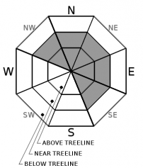
Avalanche Problem 1: Wind Slab
-
Character ?

-
Aspect/Elevation ?
-
Likelihood ?CertainVery LikelyLikelyPossible
 Unlikely
 -
Size ?HistoricVery LargeLargeSmall

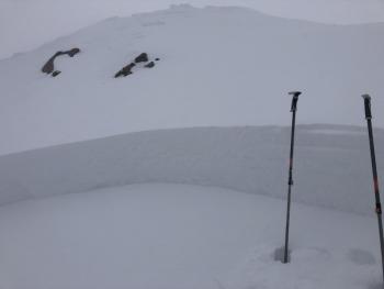
Though not much evidence of wind slabs have been encountered recently, continue to watch for unstable snow on steep isolated terrain features above treeline. If lingering wind slabs exist, expect them high in the alpine regions. Wind slab avalanches in isolated areas or extreme terrain remain possible. Warming temperatures and low winds will continue to decrease the likelihood of trigging a wind slab today. Natural wind slab avalanches are unlikely.
Forecast Discussion
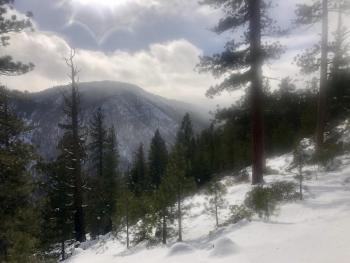
Unconsolidated snow, warm temperatures and a poor overnight refreeze will create a concern for loose wet avalanches below and near treeline today. Avoid steep slopes where you see roller balls and pinwheels.
Thank you and congratulations to the racers who competed in the 7th Annual Shasta Ascension Backcountry Race. It was wonderful to have the community's support at our 18th Annual Snow Ball as well. Thank you to everyone who donated and helped out with these events!
Recent Observations
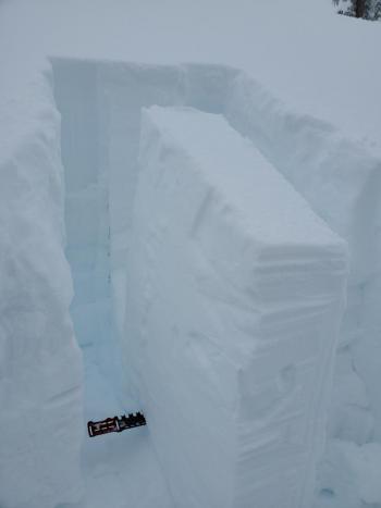
A tour up West Fork of Parks Creek in the north west Eddy's saw warm temperatures and brief misty rain showers around noon. A weak layer was recognized on north facing terrain near 6,400 feet; however, a warming and consolidating upper snow pack points towards a very low likelihood of triggering this layer. Another major loading event may raise concern for this problem. For more information see the West Fork Parks Creek persistent layer observation below.
In the last 24 hours on Mount Shasta, temperatures have ranged from 24 to 32.5 degrees F at 8,000 feet. West winds averaging 11 mi/hr have decreased and have become easterly. The Everitt Memorial Highway is open. Castle Lake Road remains closed. Expect deep moist snow with a poor overnight refreeze character below and near treeline.
Weather and Current Conditions
Weather Summary
A ridge of high pressure has set in over the area. Warmer temperatures today will allow mostly cloudy conditions to build and linger sometime after 9 AM this morning. Expect clearing skies after 3 PM then a return to mostly cloudy conditions tonight and tomorrow. Winds out of the east and south will remain light.
A weak pineapple express of a storm will move in late Monday night bringing nearly three quarters of an inch of precipitable water. This storm has some cold style even though it's of southerly nature. Elevations above 4,000 ft could receive 3-6 inches of snow by the close of business Tuesday.
24 Hour Weather Station Data @ 6:00 AM
| Weather Station | Temp (°F) | Wind (mi/hr) | Snow (in) | Comments | ||||||||
|---|---|---|---|---|---|---|---|---|---|---|---|---|
| Cur | Min | Max | Avg | Avg | Max Gust | Dir | Depth | New | Water Equivalent | Settlement | ||
| Mt. Shasta City (3540 ft) | 24 | 24 | 38 | 29.5 | 0 | N | ||||||
| Sand Flat (6750 ft) | 29 | 18 | 33 | 28 | 56 | 0 | 0 | 0 | ||||
| Ski Bowl (7600 ft) | 33 | 15.5 | 34.5 | 29 | 67.3 | 0 | 0 | 0 | ||||
| Gray Butte (8000 ft) | 32.5 | 14.5 | 33 | 28.5 | 12 | 31 | WNW | |||||
| Castle Lake (5870 ft) | down | |||||||||||
| Mount Eddy (6509 ft) | 30.5 | 18 | 38 | 29.5 | 2 | 9 | WSW | 54 | 1.2 | 4.5 | ||
| Ash Creek Bowl (7250 ft) | down | |||||||||||
| Ash Creek Ridge (7895 ft) | down |
Two Day Mountain Weather Forecast
Produced in partnership with the Medford NWS
| For 7000 ft to 9000 ft | |||
|---|---|---|---|
|
Sunday (4 a.m. to 10 p.m.) |
Sunday Night (10 p.m. to 4 a.m.) |
Monday (4 a.m. to 10 p.m.) |
|
| Weather | Mostly cloudy, clearing to partly sunny in the afternoon. | Mostly cloudy. | Mostly cloudy. |
| Temperature (°F) | 42 | 30 | 38 |
| Wind (mi/hr) | East 5-10 | South 10-15 | South 10-15 |
| Precipitation SWE / Snowfall (in) | 0.00 / 0 | 0.00 / 0 | 0.00 / 0 |
| For 9000 ft to 11000 ft | |||
| Sunday | Sunday Night | Monday | |
| Weather | Partly sunny. | Mostly cloudy. | Mostly cloudy. |
| Temperature (°F) | 33 | 23 | 23 |
| Wind (mi/hr) | South 10-15 | South 30-35 | South 30-35 |
| Precipitation SWE / Snowfall (in) | 0.00 / 0 | 0.00 / 0 | 0.00 / 0 |
Season Precipitation for Mount Shasta City
| Period | Measured (in) | Normal (in) | Percent of Normal (%) |
|---|---|---|---|
| From Oct 1, 2025 (the wet season) | 9.99 | 19.48 | 51 |
| Month to Date (since Jul 1, 2026) | 1.06 | 4.27 | 25 |
| Year to Date (since Jan 1, 2026) | 1.06 | 4.27 | 25 |

