

You are here
Avalanche Forecast for 2020-01-20 06:30
- EXPIRED ON January 21, 2020 @ 6:30 amPublished on January 20, 2020 @ 6:30 am
- Issued by Ryan Sorenson - Mount Shasta Avalanche Center
Bottom Line
Low avalanche danger exists for all elevations today. Be mindful of lingering wind slabs as you travel. Difficult to trigger (but not impossible) wind slabs may be lurking on steep isolated terrain features above treeline. Natural and human triggered avalanches are unlikely.


Avalanche Problem 1: Normal Caution
-
Character ?

-
Likelihood ?CertainVery LikelyLikelyPossible
 Unlikely
Continue to watch for unstable snow on steep isolated terrain features above treeline. Some difficult (but not impossible) to trigger wind slabs may still lurk in isolated near and above treeline terrain. Natural and human triggered avalanches will remain unlikely in most places today. Expect fresh wind slabs to begin to form early tomorrow morning as more snow and wind is forecast.
Manage your group by using good travel techniques while moving through the backcountry. Follow the Ten Commandmendments for Staying Alive in Avalanche Terrain by Bruce Tremper: Travel one at a time and leave someone in a safe spot to preform the rescue. Never cross above others. Have an escape route. Cross high on the avalanche path. Never go first without testing the stability of the slope. Start small and work your way up. Be obsessed with consequences and ask yourself why might this be wrong? Discuss at critical decision points. Carry the right equipment including an avalanche beacon, shovel and probe.
Forecast Discussion
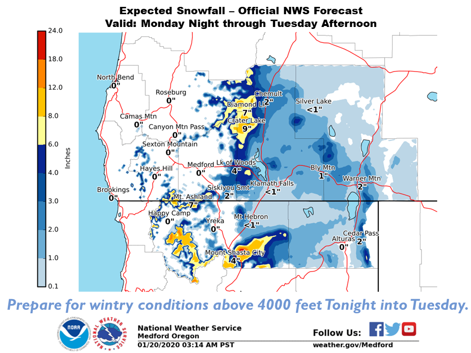
From 4 AM to 2 PM Tuesday a winter weather advisory is in effect above 3500 ft in the Mount Shasta area and a winter storm warning is in effect above 4500 feet in the Mount Shasta area and in western Siskiyou County.
Below is a map produced by the National Weather Service forecast office in Medford, OR showing expected snow fall tomorrow.
Recent Observations
-
Temperatures have ranged from 29 to 40 degrees F at 8,000 feet.
-
Wind speeds have averaged 12 mi/hr, gusting up to 31 mi/hr at 8,000 feet.
-
The height of snow (HS) at 7,600 feet is 66 inches.

Weather and Current Conditions
Weather Summary
The ridge of high pressure will gradually move east out of the area today. Expect increasing clouds and wind late this afternoon as a fast moving winter storm approaches. There is a slight chance of snow this evening then snow likely after midnight. Periods of moderate to heavy snowfall will arrive after 4 AM tomorrow then light snow showers will continue after 10 AM. Snow levels will begin around 4,000 feet tonight then drop slightly to 3,700 feet tomorrow morning. Areas of strong, gusty southerly winds will accompany the 4 to 9 inches of fresh snow forecast with this storm.
Another weak high pressure ridge is expected to build over the southwestern reaches of the area late Tuesday evening. Waves of warmer winter air will push over this ridge allowing for light snow showers to continue through Wednesday night. Snow levels could rise to 5000-6500 feet.
24 Hour Weather Station Data @ 6:00 AM
| Weather Station | Temp (°F) | Wind (mi/hr) | Snow (in) | Comments | ||||||||
|---|---|---|---|---|---|---|---|---|---|---|---|---|
| Cur | Min | Max | Avg | Avg | Max Gust | Dir | Depth | New | Water Equivalent | Settlement | ||
| Mt. Shasta City (3540 ft) | 31 | 23 | 43 | 34 | 1 | N | ||||||
| Sand Flat (6750 ft) | 30 | 29 | 35 | 32 | 55 | 0 | 0 | 0 | ||||
| Ski Bowl (7600 ft) | 29.5 | 29.5 | 42 | 36.5 | 66.3 | 0 | 0 | 0 | ||||
| Gray Butte (8000 ft) | 27.5 | 27.5 | 40 | 34.5 | 12 | 31 | SSE | |||||
| Castle Lake (5870 ft) | 0 | 0 | 0 | 0 | 0 | 0 | 0 | down | ||||
| Mount Eddy (6509 ft) | 31.5 | 30 | 45.5 | 37 | 2 | 9 | SSW | 53.4 | 0 | 0 | ||
| Ash Creek Bowl (7250 ft) | down | |||||||||||
| Ash Creek Ridge (7895 ft) | down |
Two Day Mountain Weather Forecast
Produced in partnership with the Medford NWS
| For 7000 ft to 9000 ft | |||
|---|---|---|---|
|
Monday (4 a.m. to 10 p.m.) |
Monday Night (10 p.m. to 4 a.m.) |
Tuesday (4 a.m. to 10 p.m.) |
|
| Weather | Mostly cloudy. Windy. | Mostly cloudy. Slight chance of snow in the evening then snow likely after midnight. Windy. Snow levels near 4000 feet. | Periods of moderate to heavy snowfall after 4 AM then light snow showers after 10 AM. Windy. Snow levels near 3700 feet. |
| Temperature (°F) | 39 | 29 | 31 |
| Wind (mi/hr) | South 10-15 | South 15-20 | South 10-15 |
| Precipitation SWE / Snowfall (in) | 0.00 / 0 | 0.14 / 1-2 | 0.57 / 4-8 |
| For 9000 ft to 11000 ft | |||
| Monday | Monday Night | Tuesday | |
| Weather | Partly sunny then increasing clouds. Windy. | Mostly cloudy. Slight chance of snow in the evening then snow likely after midnight. | Periods of moderate to heavy snowfall after 4 AM then light snow showers after 10 AM. Windy. |
| Temperature (°F) | 23 | 19 | 21 |
| Wind (mi/hr) | South 30-35 | South 35-40 | South 45-50 |
| Precipitation SWE / Snowfall (in) | 0.00 / 0 | 0.14 / 1-2 | 0.57 / 4-9 |
Season Precipitation for Mount Shasta City
| Period | Measured (in) | Normal (in) | Percent of Normal (%) |
|---|---|---|---|
| From Oct 1, 2025 (the wet season) | 9.99 | 19.69 | 51 |
| Month to Date (since Jul 1, 2026) | 1.06 | 4.48 | 24 |
| Year to Date (since Jan 1, 2026) | 1.06 | 4.48 | 24 |

