

You are here
Avalanche Forecast for 2020-01-21 06:30
- EXPIRED ON January 22, 2020 @ 6:30 amPublished on January 21, 2020 @ 6:30 am
- Issued by Aaron Beverly - Mount Shasta Avalanche Center
Bottom Line
Avalanche danger will become MODERATE today as new snow and strong winds combine to form new wind slabs near and above treeline. Human triggered avalanches will be possible. Evaluate the snowpack carefully if traveling on or near slopes greater than 35 degrees.


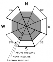
Avalanche Problem 1: Wind Slab
-
Character ?

-
Aspect/Elevation ?
-
Likelihood ?CertainVery LikelyLikelyPossible
 Unlikely
 -
Size ?HistoricVery LargeLargeSmall

With up to 6 inches of new snow expected today along with strong south and west winds, new wind slabs may form. They could be 12 to 18 inches deep. Evaluate the snowpack carefully if traveling on or near slopes greater than 35 degrees. Human triggered wind slab avalanches are possible. Shooting cracks, blocking, and hollow sounding snow are signs that wind slabs may be reactive to human trigger. Stomping on small rollovers and wind drifts above low angle terrain is a good way to test for the wind slab problem.
Expect wind slabs on north and easterly aspects, but mountain winds today will be variable. Pay attention to where winds are blowing snow and be prepared for wind slabs on any leeward terrain.
Forecast Discussion
It's going to be wild and woolly out there today for a brief moment. An inch an hour of snow may be seen this morning. Winds could reach gale force speeds. You'll probably want to stay below treeline, but if you are seeking enlightenment through suffering, you'll find it above treeline. Bring a puffy, good mittens, and extra layers for your journey. A probe, shovel, and avalanche transceiver are mandatory. Know how to use them.
Recent Observations
In the last 24 hours on Mount Shasta no discernible snow accumulation has been measured, though precipitation started around 2 a.m. Temperatures have ranged from 23 to 32 degrees. Southerly winds have been light, averaging 9 mi/hr, gusting up to 31. The current snow depth is 66 inches.
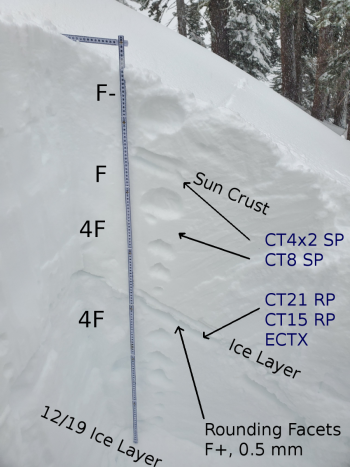
Snow below treeline yesterday was wet and heavy with boot penetration up to your knees. Snow surfaces above treeline are variable with a mix of crusts, sastrugi, and wind hardened snow. Wind protected areas still host some lower density snow.
Though some wind slabs exist on easterly aspects, these are isolated and not reactive. No obvious signs of avalanche danger have been seen.

Weather and Current Conditions
Weather Summary
A winter storm warning is in effect from 4 a.m. to 2 p.m. Snow levels could drop to as low as 3,000 ft. Expect 3-6 inches of snow accompanied by strong to gale force southerly winds above treeline. The heaviest snowfall will occur this morning.
A warm front will move in Wednesday afternoon raising snow levels to above 6,000 ft, though little precipitation is expected.
This weekend looks to be a rainy one, with snow levels as high at 6,000 ft.
24 Hour Weather Station Data @ 5:00 AM
| Weather Station | Temp (°F) | Wind (mi/hr) | Snow (in) | Comments | ||||||||
|---|---|---|---|---|---|---|---|---|---|---|---|---|
| Cur | Min | Max | Avg | Avg | Max Gust | Dir | Depth | New | Water Equivalent | Settlement | ||
| Mt. Shasta City (3540 ft) | 34 | 31 | 46 | 37.5 | 3 | N | ||||||
| Sand Flat (6750 ft) | 27 | 27 | 35 | 31 | 53 | 0 | 0 | 2 | ||||
| Ski Bowl (7600 ft) | 23 | 22.5 | 32 | 27 | 66.5 | 1 | 0.11 | 1 | ||||
| Gray Butte (8000 ft) | 22.5 | 21 | 30 | 25 | 10 | 31 | S | |||||
| Castle Lake (5870 ft) | 0 | down | ||||||||||
| Mount Eddy (6509 ft) | 26 | 26 | 34.5 | 29.5 | 2 | 13 | SSW | 53.8 | 1 | 1 | ||
| Ash Creek Bowl (7250 ft) | down | |||||||||||
| Ash Creek Ridge (7895 ft) | down |
Two Day Mountain Weather Forecast
Produced in partnership with the Medford NWS
| For 7000 ft to 9000 ft | |||
|---|---|---|---|
|
Tuesday (4 a.m. to 10 p.m.) |
Tuesday Night (10 p.m. to 4 a.m.) |
Wednesday (4 a.m. to 10 p.m.) |
|
| Weather | Snow before 10 a.m., then snow showers, mainly between 10 a.m. and 4p.m. Breezy. Chance of precipitation is 100%. | Mostly cloudy. | A 50 percent chance of snow. Cloudy. |
| Temperature (°F) | 29 | 28 | 33 |
| Wind (mi/hr) | South 15-20 | Southwest 10-15 | South 10-15 |
| Precipitation SWE / Snowfall (in) | 0.57 / 3-6 | 0.00 / 0 | 0.03 / 0-0.50 |
| For 9000 ft to 11000 ft | |||
| Tuesday | Tuesday Night | Wednesday | |
| Weather | Snow before 10 a.m., then snow showers, mainly between 10 a.m. and 4p.m. The snow could be heavy at times. Very windy and gusty. Low wind chills. Chance of precipitation is 100%. | A chance of snow showers. Mostly cloudy, with a rising temperatures. Windy and gusty. Low wind chills. | Snow likely, mainly before 10 a.m. Cloudy. Windy and gusty. Low wind chills. Chance of precipitation is 60%. |
| Temperature (°F) | 21 | 18 | 27 |
| Wind (mi/hr) | Southwest 45-55 | West 30-35 | West 30-40 |
| Precipitation SWE / Snowfall (in) | 0.57 / 3-6 | 0.00 / 0 | 0.03 / 0-0.50 |
Season Precipitation for Mount Shasta City
| Period | Measured (in) | Normal (in) | Percent of Normal (%) |
|---|---|---|---|
| From Oct 1, 2025 (the wet season) | 9.99 | 19.91 | 50 |
| Month to Date (since Jul 1, 2026) | 1.06 | 4.70 | 23 |
| Year to Date (since Jan 1, 2026) | 1.06 | 4.70 | 23 |

