

You are here
Avalanche Forecast for 2020-01-22 06:30
- EXPIRED ON January 23, 2020 @ 6:30 amPublished on January 22, 2020 @ 6:30 am
- Issued by Aaron Beverly - Mount Shasta Avalanche Center
Bottom Line
Avalanche danger remains MODERATE near and above treeline. Plenty of snow from yesterday's storm is available for transport and productive winds are expected today. Evaluate the snowpack carefully in the forecast zone you are in. Different conditions exist in different locations. Human triggered avalanches will be possible on steep leeward terrain.


Avalanche Problem 1: Wind Slab
-
Character ?

-
Aspect/Elevation ?
-
Likelihood ?CertainVery LikelyLikelyPossible
 Unlikely
 -
Size ?HistoricVery LargeLargeSmall

No signs of a wind slab problem were observed on Mount Shasta yesterday, but the signs were definitely presenting in the Eddies. We have a large coverage area and variable conditions throughout. What one sees in one place may be very different in another. Evaluate the snowpack carefully for the zone you are in.
If winds speeds verify today, wind slabs may form (or continue to form) near and above treeline. There is 5-7 inches of low density snow available for transport.
Shooting cracks, blocking, and hollow sounding snow are signs that wind slabs may be reactive to human trigger. Stomping on small rollovers and wind drifts above low angle terrain is a good way to test for the wind slab problem.
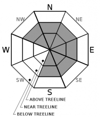
Expect wind slabs primarily on north and easterly aspects, but pay attention to where winds are blowing snow and be prepared for wind slabs on any leeward terrain.
Forecast Discussion
Some evidence of a storm slab problem were seen yesterday. Storm slabs are a release of a cohesive layer of new snow that breaks within new snow or on the old snow surface. This type of problem is short lived and is unlikely today. Still, if you plan to be on slopes approaching 40 degrees, don't rule out storm slabs. Stomp around the edges of tree wells or on short steep areas of no consequence. If snow slides in a blocky, consolidated manner, then this problem could be lurking.
Recent Observations
In the last 24 hours, Mount Shasta has received about 7 inches of new snow. West / northwest winds have averaged 16 mi/hr, peaking at 23 mi/hr, and gusting up to 37. Despite these measurements on Gray Butte, observed winds yesterday afternoon were calm to light on Green Butte Ridge above treeline with no wind affect on snow surfaces seen.
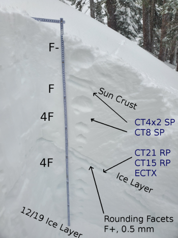
The warming storm created a slight up-side down configuration in the new 4-6 inches of snow and some cracking and blocking were seen that indicated the presence of a storm slab problem. A faceted layer exists below a thin ice layer about 78 cm down, though it was hard to trigger failures on it and no propagation occurred in ECT tests. No signs of a wind slab problem were seen. In fact, winds were unusually calm and snow surfaces smooth and fluffy, even above treeline. See yesterday's observation for details.
The Eddies told a different story. Active wind loading was seen on northerly aspects. Hollow sounding wind slabs over 3 feet deep were encountered. Collapsing snow along skin tracks was felt. These were all good indicators of the presence of a wind slab problem and skiers avoided wind affected terrain.

Weather and Current Conditions
Weather Summary
An incoming warm front will bring rising temperatures today. Snow levels will increase to over 6,000 ft by this afternoon. The amount of snow that may fall is barely worth mentioning - less than half an inch. Winds above treeline will be out of the west and could reach moderate speeds (20-25 mi/hr).
The next significant precipitation event arrives early Saturday morning. By Sunday night, we could get close to an inch and a half of water. Unfortunately, a southerly flow of air will keep snow levels high - above 6,000 ft.
24 Hour Weather Station Data @ 5:00 AM
| Weather Station | Temp (°F) | Wind (mi/hr) | Snow (in) | Comments | ||||||||
|---|---|---|---|---|---|---|---|---|---|---|---|---|
| Cur | Min | Max | Avg | Avg | Max Gust | Dir | Depth | New | Water Equivalent | Settlement | ||
| Mt. Shasta City (3540 ft) | 34 | 33 | 38 | 35 | 2 | N | ||||||
| Sand Flat (6750 ft) | 26 | 25 | 29 | 27 | 58 | 3 | 0 | 0 | ||||
| Ski Bowl (7600 ft) | 22 | 21 | 25 | 23 | 72.9 | 7 | 0.51 | 0 | ||||
| Gray Butte (8000 ft) | 21.5 | 19.5 | 24.5 | 22 | 16 | 37 | WNW | |||||
| Castle Lake (5870 ft) | down | |||||||||||
| Mount Eddy (6509 ft) | 30 | 25 | 31 | 27 | 2 | 16 | WSW | 54.4 | 2 | 1 | ||
| Ash Creek Bowl (7250 ft) | down | |||||||||||
| Ash Creek Ridge (7895 ft) | down |
Two Day Mountain Weather Forecast
Produced in partnership with the Medford NWS
| For 7000 ft to 9000 ft | |||
|---|---|---|---|
|
Wednesday (4 a.m. to 10 p.m.) |
Wednesday Night (10 p.m. to 4 a.m.) |
Thursday (4 a.m. to 10 p.m.) |
|
| Weather | A 50 percent chance of snow. Mostly cloudy. | Mostly cloudy, with temperatures rising. | A chance of rain and snow, mainly after 4 p.m. Snow level 7000 feet. Chance of precipitation is 30%. |
| Temperature (°F) | 33 | 35 | 37 |
| Wind (mi/hr) | South 5-10 | South 5-10 | South 5-10 |
| Precipitation SWE / Snowfall (in) | 0.03 / 0-0.20 | 0.00 / 0 | 0.00 / 0 |
| For 9000 ft to 11000 ft | |||
| Wednesday | Wednesday Night | Thursday | |
| Weather | Snow likely. Mostly cloudy. Windy and gusty. Chance of precipitation is 60%. | Mostly cloudy. Breezy. | A 30 percent chance of snow, mainly after 4 p.m. Partly sunny. Breezy. |
| Temperature (°F) | 25 | 24 | 28 |
| Wind (mi/hr) | West 20-25 | West 15-20 | Southwest 15-20 |
| Precipitation SWE / Snowfall (in) | 0.03 / 0-0.30 | 0.00 / 0 | 0.00 / 0 |
Season Precipitation for Mount Shasta City
| Period | Measured (in) | Normal (in) | Percent of Normal (%) |
|---|---|---|---|
| From Oct 1, 2025 (the wet season) | 10.49 | 20.13 | 52 |
| Month to Date (since Jul 1, 2026) | 1.56 | 4.92 | 32 |
| Year to Date (since Jan 1, 2026) | 1.56 | 4.92 | 32 |

