

You are here
Avalanche Forecast for 2020-01-23 06:21
- EXPIRED ON January 24, 2020 @ 6:21 amPublished on January 23, 2020 @ 6:21 am
- Issued by Nick Meyers - Shasta-Trinity National Forest
Bottom Line
LOW danger and normal caution is advised for daylight hours today, all aspects and elevations. Expect MODERATE avalanche hazard tonight as a few inches of new snow combine with southwesterly wind. Fresh wind slabs are possible by tomorrow morning above treeline.


Avalanche Problem 1: Wind Slab
-
Character ?

-
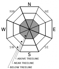
Aspect/Elevation ?
-
Likelihood ?CertainVery LikelyLikelyPossible
 Unlikely
 -
Size ?HistoricVery LargeLargeSmall

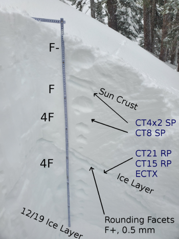
Watch for fresh wind slabs that may form tonight due to increasing southwesterly winds and a few inches of new snow. This problem will be confined to primarily above treeline terrain on north and east aspects, but not limited to. Wind slabs will likely be small, but could be easy to trigger.
Above treeline yesterday, it was difficult to get a good assessment of the wind slab hazard due to poor visibility. That said, warm temperatures and a general lack of wind and previous wind effect on the snow indicates that consequential wind slabs are unlikely today.
Learn more about wind slabs HERE!
Forecast Discussion
We often ski and ride in the same areas over and over again throughout the winter. Many are intimately familiar with what terrain is safe, and what is not. Our forecast area is widely varied. One side of the interstate, a 14,179 foot peak sticks out thousands of feet higher than any other piece of terrain. On the west side, more typical mountains of Northern California exist. Wind can present itself in perplexing ways, blowing in the complete opposite direction of the main airflow, especially on Mount Shasta. Howling wind in one area might be met with completely calm wind somewhere else. As you ski and ride in different areas within the forecast area, just remember that what one sees in one place may be very different in another.
Preparing for an avalanche course or just need a refresher? Check out the teaser below and then login for the Know Before You Go FREE interactive online learning courses. Click Here
Recent Observations
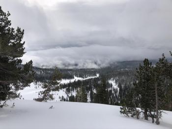
Yesterday, an afternoon jaunt up the south side of Mount Shasta did not reveal much as visibility was very poor. Overall, warming temperatures have help consolidate and stabilize most avalanche problems. A brief doughnut hole in the clouds and fog allowed a quick foray to 9,500 feet (above treeline) in the Old Ski Bowl. Wind effect was minimal. Some subtle texturing was observed over exposed terrain and snow surfaces consisted of a mix of wind packed powder and softer snow. Lower elevations near and below treeline, moist, heavier snow was not conducive for wind transport and snow surfaces remain smooth and uniform. Minor storm slab hazard has subsided from the day prior. Wind yesterday was remarkably calm at Bunny Flat and in the Old Ski Bowl, though on Gray Butte wind speeds averaged 12 mi/hr with gusts to 17 mi/hr. Temperatures at treeline have averaged 26.5 F, with a low of 21.5 F and high of 29.5 F.

Weather and Current Conditions
Weather Summary
Now through the weekend, the weather will act in an 'on again -- off again' manner. Several warm and short-lived cold fronts will pass through the area. Today, a cold front approaches with moderate precipitation forecast to fall mostly during the dark PM hours. Snow levels will fall from 7,200 feet today to 5,600 feet tonight. By Friday, a few inches of snow is possible out of this one with snow-water equivalents near .18 inches. Expect increasing southwesterly wind with this system as well.
A stronger low approaches the coast this weekend. Snow levels, much to our chagrin, will rise to near 7,400 feet.
24 Hour Weather Station Data @ 4:00 AM
| Weather Station | Temp (°F) | Wind (mi/hr) | Snow (in) | Comments | ||||||||
|---|---|---|---|---|---|---|---|---|---|---|---|---|
| Cur | Min | Max | Avg | Avg | Max Gust | Dir | Depth | New | Water Equivalent | Settlement | ||
| Mt. Shasta City (3540 ft) | 35 | 34 | 41 | 36.5 | 1 | N | ||||||
| Sand Flat (6750 ft) | 32 | 26 | 33 | 30 | 57 | 1 | 0 | 2 | ||||
| Ski Bowl (7600 ft) | 28.5 | 21.5 | 29.5 | 26.5 | 71.4 | 3 | 0.08 | 4.8 | ||||
| Gray Butte (8000 ft) | 28.5 | 21 | 29.5 | 26.5 | 12 | 25 | W | |||||
| Castle Lake (5870 ft) | 0 | 0 | 0 | 0 | 0 | 0 | 0 | down | ||||
| Mount Eddy (6509 ft) | 31.5 | 26.5 | 36.5 | 30.5 | 2 | 9 | E | 52.5 | 0.8 | 3 | ||
| Ash Creek Bowl (7250 ft) | down | |||||||||||
| Ash Creek Ridge (7895 ft) | down |
Two Day Mountain Weather Forecast
Produced in partnership with the Medford NWS
| For 7000 ft to 9000 ft | |||
|---|---|---|---|
|
Thursday (4 a.m. to 10 p.m.) |
Thursday Night (10 p.m. to 4 a.m.) |
Friday (4 a.m. to 10 p.m.) |
|
| Weather | Mostly cloudy with a 30% chance of rain after 10 AM. Snow level rising from 6,900 feet to 7,700 feet in the afternoon. Temps falling. | Rain mixed with snow. Snow level near 7,300 feet lowering to 6,800 feet. Temperatures steady. Chance of precip 90%. | Snow showers, mainly before 10 AM. Mostly cloudy. Chance of precip 60%. Snow level near 5,600 feet. |
| Temperature (°F) | 35 | 34 | 33 |
| Wind (mi/hr) | South 5-10 | South 5-10 | Southwest 5-10 |
| Precipitation SWE / Snowfall (in) | 0.08 / 0 | 0.18 / 1-3 | 0.02 / 0-0.50 |
| For 9000 ft to 11000 ft | |||
| Thursday | Thursday Night | Friday | |
| Weather | Mostly cloudy with a 30% chance of snow after 10 AM. Breezy. | Snow and windy. Chance of precip 90%. | Mostly cloudy, chance of snow showers before 10 AM. Windy. Chance of precip 60%. |
| Temperature (°F) | 27 | 17 | 25 |
| Wind (mi/hr) | Southwest 20-25 | Southwest 20-30 | West 20-30 |
| Precipitation SWE / Snowfall (in) | 0.08 / 1-2 | 0.18 / 4-8 | 0.02 / 0-1 |
Season Precipitation for Mount Shasta City
| Period | Measured (in) | Normal (in) | Percent of Normal (%) |
|---|---|---|---|
| From Oct 1, 2025 (the wet season) | 10.49 | 20.35 | 52 |
| Month to Date (since Jul 1, 2026) | 1.56 | 5.14 | 30 |
| Year to Date (since Jan 1, 2026) | 1.56 | 5.14 | 30 |

