

You are here
Avalanche Forecast for 2020-01-24 05:48
- EXPIRED ON January 25, 2020 @ 5:48 amPublished on January 24, 2020 @ 5:48 am
- Issued by Nick Meyers - Shasta-Trinity National Forest
Bottom Line
The avalanche danger is LOW for all aspects and elevations today. Use NORMAL CAUTION.
Watch for the 5 red flags of avalanche danger any time you're in the backcountry.


Avalanche Problem 1: Normal Caution
-
Character ?

-
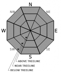
Aspect/Elevation ?
-
Likelihood ?CertainVery LikelyLikelyPossible
 Unlikely
 -
Size ?HistoricVery LargeLargeSmall

Warm temperatures have nixed any life threatening avalanche problems for now. Despite .48" inches of SWE (snow/water equivalent) overnight, new snow barely accumulated. Westerly wind has been moderate, but available snow for transport is slim to none. Use NORMAL CAUTION out there today.
The 5 RED FLAGS of avalanche danger are true anywhere you have steep mountains and snow on the ground. Engrave them into your brain:
1- Recent Avalanches: If there are new avalanches, more are possible.
2- Signs of Unstable Snow: Shooting cracks, collapsing or whumpfing noises, or hollow drum-like sounds.
3- Heavy Snowfall or Rain: Recent significant snowfall or rain can make the snowpack unstable. Avalanches are often triggered immediately during or just after a storm.
4-Wind Drifting: Wind blown snow can load slopes even when it's not snowing.
5- Rapid Warming: Warm temperatures can cause snow to become saturated and less stable
Think about the consequences... if you get caught, could an avalanche carry you into trees or other terrain traps, like gullies or cliffs below.
Forecast Discussion
It's been quite warm lately and tomorrow will be even warmer. For the anti-winter folk, you're psyched! For the powder hounds, not so much. Warm temperatures and rain on snow always make us think about loose-wet avalanches. In warm conditions, or with rain on snow, snow grains may have low cohesion due to an excess of water in the snow and wet loose snow avalanches (or sluffs) can occur. Loose snow avalanches are much different in nature than slab avalanches. Few injuries or fatalities result from loose snow avalanches. They are the most dangerous if there is a terrain trap below, such as trees, a cliff band or narrow ravine. Monitor the snowpack surface for a layer of wet, slushy snow more than several inches deep. Fresh roller balls indicate that the snowpack surface is getting weak. Loose wet avalanches can trigger slab avalanches that break into deeper snow layers. We don't expect this to be a problem today, but a good time to chat about it with rain on snow and warm temps in the forecast tomorrow.
Recent Observations
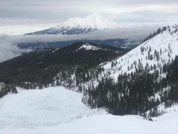
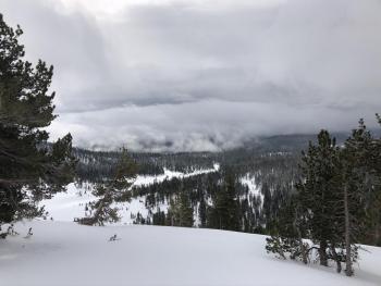
- A warm and mostly cloudy day with a gradually lowering cloud deck diminished visibility on Mt Shasta yesterday
- Temperatures at treeline - Avg: 31.5 F / Max: 34.5 F / Min: 28 F
- Raining/dripping out of trees
- Widespread settlement within snowpack
- Creamy, warm, moist snow below and near treeline / Subtle wind effect above treeline. No dry snow available for wind transport. Winds light in the Horse Camp and Giddy Giddy Gulch area. On Gray Butte westerly wind averaged 14 mi/hr and maxed at 25 mi/hr.
- Precipitation began at 1600 hours but has struggled to accumulate. Snow water equivalent of .48" fell overnight with only two inches of snow measuring at the Old Ski Bowl station this morning at 0500.
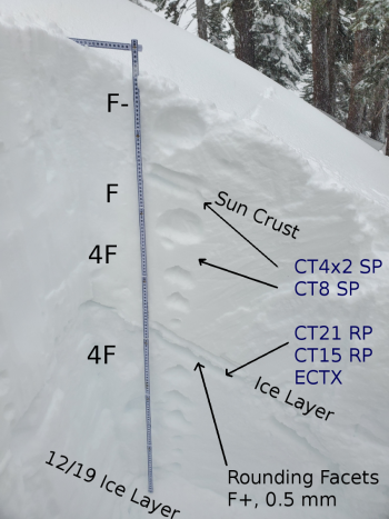
- The 12/19 crust-facet layer continues to be observed in select areas below and near treeline. This layer has not been reactive in snowpit tests.

Weather and Current Conditions
Weather Summary
A spritz of rain/snow this morning will otherwise be followed by dry conditions for the day and perhaps even sunshine poking through at times. This will be short-lived as increasing clouds begin to filter in this afternoon, signifying the beginning of a stronger and wetter system. Saturday will host a very warm, westerly moving surface low. This system will bring modest water amounts with it (.37') with snow levels near 7,000 to 8,000 feet. Aye yes, we feel the pain of that information. The balmy weather aforementioned is followed by a cold front and showery pattern Sunday, with snow levels lowering down to 4,500 to 5,500 feet. Moderate westerly wind is expected above treeline over the ridge tops. Winds at lower elevations will be mostly calm and variable.
24 Hour Weather Station Data @ 4:00 AM
| Weather Station | Temp (°F) | Wind (mi/hr) | Snow (in) | Comments | ||||||||
|---|---|---|---|---|---|---|---|---|---|---|---|---|
| Cur | Min | Max | Avg | Avg | Max Gust | Dir | Depth | New | Water Equivalent | Settlement | ||
| Mt. Shasta City (3540 ft) | 39 | 34 | 45 | 39.5 | 1 | N | ||||||
| Sand Flat (6750 ft) | 33 | 29 | 34 | 33 | 56 | |||||||
| Ski Bowl (7600 ft) | 29 | 28 | 34.5 | 31.5 | 72.2 | 2.7 | 0.48 | 1.9 | ||||
| Gray Butte (8000 ft) | 28 | 27.5 | 32.5 | 30.5 | 14 | 25 | WNW | |||||
| Castle Lake (5870 ft) | 0 | 0 | 0 | 0 | 0 | 0 | 0 | down | ||||
| Mount Eddy (6509 ft) | 30.5 | 30.5 | 41 | 34.5 | 1 | 8 | SSE | 49 | 2 | 3 | ||
| Ash Creek Bowl (7250 ft) | down | |||||||||||
| Ash Creek Ridge (7895 ft) | down |
Two Day Mountain Weather Forecast
Produced in partnership with the Medford NWS
| For 7000 ft to 9000 ft | |||
|---|---|---|---|
|
Friday (4 a.m. to 10 p.m.) |
Friday Night (10 p.m. to 4 a.m.) |
Saturday (4 a.m. to 10 p.m.) |
|
| Weather | Partly cloudy, chance of showers. Snow level near 5,500 feet. | Increasing clouds, rain and snow likely. Snow level near 6,000 feet. | Rain, mixed with snow. Snow levels near 7,400 feet. |
| Temperature (°F) | 36 | 32 | 39 |
| Wind (mi/hr) | Southwest 5-10 | South 5-10 | South 5-10 |
| Precipitation SWE / Snowfall (in) | 0.01 / 0-0.50 | 0.05 / 0-1 | 0.37 / 0 |
| For 9000 ft to 11000 ft | |||
| Friday | Friday Night | Saturday | |
| Weather | Snow showers mainly before 10 AM, becoming partly cloudy. | Increasing clouds, mostly cloudy, snow likely. | Snow. Windy. |
| Temperature (°F) | 25 | 23 | 25 |
| Wind (mi/hr) | West 20-30 | West 20-30 | West 20-30 |
| Precipitation SWE / Snowfall (in) | 0.01 / 0-1 | 0.05 / 2-4 | 0.37 / 2-4 |
Season Precipitation for Mount Shasta City
| Period | Measured (in) | Normal (in) | Percent of Normal (%) |
|---|---|---|---|
| From Oct 1, 2025 (the wet season) | 12.11 | 20.57 | 59 |
| Month to Date (since Jul 1, 2026) | 3.18 | 5.36 | 59 |
| Year to Date (since Jan 1, 2026) | 3.18 | 5.36 | 59 |

