

You are here
Avalanche Forecast for 2020-01-25 07:05
- EXPIRED ON January 26, 2020 @ 7:05 amPublished on January 25, 2020 @ 7:05 am
- Issued by Ryan Sorenson - Mount Shasta Avalanche Center
Bottom Line
LOW avalanche danger today will rise to MODERATE above treeline this evening as new snow and wind could form fresh wind slabs on easterly facing terrain. Natural avalanches are unlikely. Human triggered avalanches are possible, mainly late this evening on steep, alpine terrain on Mount Shasta.


Avalanche Problem 1: Wind Slab
-
Character ?

-
Aspect/Elevation ?
-
Likelihood ?CertainVery LikelyLikelyPossible
 Unlikely
 -
Size ?HistoricVery LargeLargeSmall

Consistent westerly wind and new snow is forecast today. Recent warm temperatures have diminished the availability of old snow for transport, however, isolated steep east-facing terrain may host lingering wind slabs in the alpine on Mount Shasta. New snow today could continue to form wind slabs primarily on easterly aspects above treeline. The warm temperature will allow for a good bond with underlying snow surfaces but keep an eye out for wind slabs on isolated or extreme alpine terrain. Natural avalanches are unlikely but large human triggered wind slab avalanches are possible above treeline primarily late this evening as the majority of new snow falls above 7,600 feet.
Evaluate snow and terrain carefully and identify features of concern especially if you plan to enter terrain grater than 35 degrees in the alpine today. Signs that wind slabs might be nearby include shooting cracks, blocking, whumphing, scoured areas or wind drifts.
Forecast Discussion
While unlikely, warm temperatures and rain on snow could cause some concern of loose-wet avalanches. In warm conditions, or with rain on snow, snow grains may have low cohesion due to an excess of water in the snow and wet loose snow avalanches (or sluffs) can occur. Loose snow avalanches are much different in nature than slab avalanches. Few injuries or fatalities result from loose snow avalanches. They are the most dangerous if there is a terrain trap below, such as trees, a cliff band or narrow ravine. Monitor the snowpack surface for a layer of wet, slushy snow more than several inches deep. Fresh roller balls indicate that the snowpack surface is getting weak. Loose wet avalanches can trigger slab avalanches that break into deeper snow layers. We don't expect this to be a problem today, but with rain on snow and warm temperatures in the forecast, this is something to keep in mind.
Recent Observations
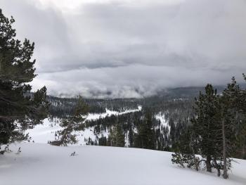
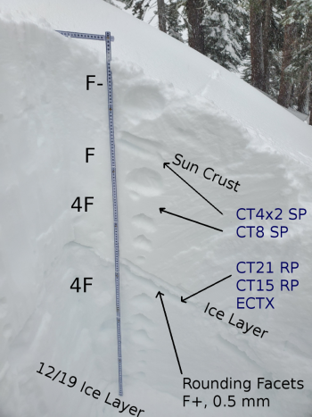
Evidence of rain on snow below approximately 6,500 feet has been observed around the forecast area. Punchy snow up to about 5,600 feet has been reported from Castle Lake. Higher elevations host more supportable snow surfaces with occasional soft spots. Widespread settlement has occurred within the existing snowpack below and near treeline.
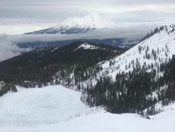
Elevations above approximately 7,500 feet on Mount Shasta paints a drastically different picture. A tour up Gray Butte found wintry conditions with 1 to 2 inches of new snow over a supportable crust and moist snow beneath. Wind buffed powdery snow, small isolated wind slabs and wind loaded east-facing aspects have been reported from upper elevations in Avalanche Gulch.
In the last 24 hours on Mount Shasta:
- Temperatures have ranged from 23 to 30 degrees F at 8,000 feet.
- Wind speeds have averaged 12 mi/hr, gusting up to 25 mi/hr at 8,000 feet.
- The height of snow (HS) at 7,600 feet is 72 inches.

Weather and Current Conditions
Weather Summary
A warm Pacific storm with a modest amount of water (0.71 inches of SWE) is currently impacting the area. Balmy conditions with high snow levels near 7,800 feet are forecast today. Gradually increasing mixed rain and snow showers will continue. Expect the heaviest precipitation to arrive late tonight into tomorrow morning. Snow levels are predicted to drop slightly to 7,600 feet tonight, then continue to drop to 5,600 feet tomorrow. Elevations above the 7,600-foot level will receive 2 to 9 inches of total snowfall by tomorrow night. A level of uncertainty remains in snow totals for lower elevations, but unfortunately, the gist is don't expect much.
Colder, mostly cloudy and drier conditions will set in tomorrow afternoon. There is a very slight chance of continued snow showers for the rest of the weekend. A second storm is scheduled to arrive early Monday morning. Gradually increasing snow showers are expected. There is slightly less available water (0.36 inches of SWE) in this storm but snow levels should remain near 4,800 feet through Tuesday morning.
24 Hour Weather Station Data @ 6:00 AM
| Weather Station | Temp (°F) | Wind (mi/hr) | Snow (in) | Comments | ||||||||
|---|---|---|---|---|---|---|---|---|---|---|---|---|
| Cur | Min | Max | Avg | Avg | Max Gust | Dir | Depth | New | Water Equivalent | Settlement | ||
| Mt. Shasta City (3540 ft) | 44 | 37 | 44 | 39.5 | 0 | N | ||||||
| Sand Flat (6750 ft) | 33 | 29 | 34 | 32 | 56 | 0 | 0 | 0 | ||||
| Ski Bowl (7600 ft) | 31.5 | 24.5 | 31.5 | 27 | 72 | 1 | 0.18 | 1 | ||||
| Gray Butte (8000 ft) | 30.5 | 23 | 30.5 | 26.5 | 12 | 25 | WNW | |||||
| Castle Lake (5870 ft) | 0 | 0 | 0 | 0 | 0 | 0 | 0 | down | ||||
| Mount Eddy (6509 ft) | 32 | 27.5 | 34 | 31 | 1 | 7 | S | 50.9 | 4 | 1 | ||
| Ash Creek Bowl (7250 ft) | down | |||||||||||
| Ash Creek Ridge (7895 ft) | down |
Two Day Mountain Weather Forecast
Produced in partnership with the Medford NWS
| For 7000 ft to 9000 ft | |||
|---|---|---|---|
|
Saturday (4 a.m. to 10 p.m.) |
Saturday Night (10 p.m. to 4 a.m.) |
Sunday (4 a.m. to 10 p.m.) |
|
| Weather | Cloudy. Mixed rain and snow. Chance of precipitation is 80%. Snow levels near 7,800 feet. | Mixed rain and snow, then snow likely after midnight. chance of precipitation is 100%. Snow levels near 7,600 feet | Mostly cloudy. Snow likely in the morning, then chance of snow showers. Chance of precipitation is 70%. Snow levels near 5,600 feet. |
| Temperature (°F) | 41 | 33 | 36 |
| Wind (mi/hr) | South 10-15 | South 20-25 | Southwest 10-15 |
| Precipitation SWE / Snowfall (in) | 0.43 / 1-5 | 0.25 / 1-3 | 0.03 / 0-1 |
| For 9000 ft to 11000 ft | |||
| Saturday | Saturday Night | Sunday | |
| Weather | Snow. Windy. Chance of snow is 80% | Snow, periods of moderate to heavy snowfall. Chance of snow near 100%. Windy, wind chill values as low as -5. | Snow likely before 10 AM, then snow showers possible. Chance of snow is 70%. Windy, wind chill values as low as -11. |
| Temperature (°F) | 27 | 19 | 19 |
| Wind (mi/hr) | West 30-35 | Southwest 35-40 | West 20-30 |
| Precipitation SWE / Snowfall (in) | 0.43 / 2-7 | 0.25 / 1-4 | 0.03 / 0-1 |
Season Precipitation for Mount Shasta City
| Period | Measured (in) | Normal (in) | Percent of Normal (%) |
|---|---|---|---|
| From Oct 1, 2025 (the wet season) | 12.26 | 20.79 | 59 |
| Month to Date (since Jun 1, 2026) | 3.33 | 5.58 | 60 |
| Year to Date (since Jan 1, 2026) | 3.33 | 5.58 | 60 |

