

You are here
Avalanche Forecast for 2020-01-28 07:00
- EXPIRED ON January 29, 2020 @ 7:00 amPublished on January 28, 2020 @ 7:00 am
- Issued by Aaron Beverly - Mount Shasta Avalanche Center
Bottom Line
A few inches of new snow may combine with moderate westerly winds to form wind slabs on leeward aspects. It may be possible to trigger small avalanches on steep terrain. Evaluate snowpack, weather, and terrain carefully today. After this afternoon, dryer conditions will prevail until Sunday.


Avalanche Problem 1: Wind Slab
-
Character ?

-
Aspect/Elevation ?
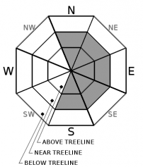
-
Likelihood ?CertainVery LikelyLikelyPossible
 Unlikely
 -
Size ?HistoricVery LargeLargeSmall

A few inches of new snow may be out there near and above treeline by late morning. Westerly winds at moderate speeds could transplant this snow onto leeward aspects in the form of small, shallow wind slabs. These may be sensitive to human-trigger on steep slopes. Look for them primarily on easterly aspects or cross loaded areas facing to the north and south.
Stomp around on convex, newly wind drifted areas of no consequence. Do you get something to move in a blocky, consolidated manner? If so, avoid loaded terrain with angles greater than 35 degrees.
Forecast Discussion
It is feeling more like a LOW avalanche danger day. However, if optimistic snow amounts and wind speeds verify, danger could increase to MODERATE. How much snow has fallen and is it being transported by the wind?
Though the size of an avalanche is expected to be small, being caught in one could sweep you into undesirable terrain. Think about consequences and monitor conditions as you travel. Evaluate snowpack, weather, and terrain carefully.
Recent Observations
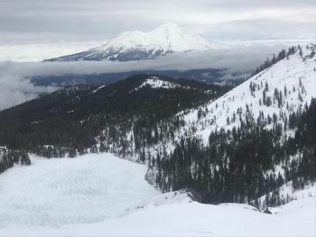
Overnight, Mount Shasta received 1-2 inches of snow. Winds were light and out of the west. Temperatures remained below freezing.
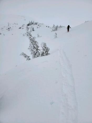
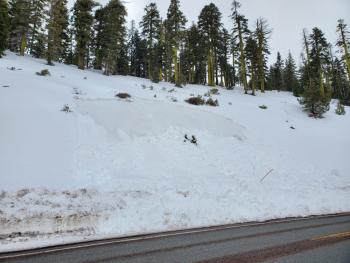
Snow levels were near 6,000 feet yesterday. Above treeline, snow surfaces are wind affected: scoured, chalky wind board, sastrugis, and shallow drifts on top of a widespread thin crust. Small, wet slab avalanches were seen Sunday along the road cut below Bunny Flat that failed within saturated, slushy, unbonded snow. The unusual nature of the unsupported snowpack along the road cut was the main contributing factor to these avalanches. At Castle Lake, east facing and other sun exposed aspects below treeline are also saturated, but no slides there have been seen. Weak layers still exist within our shallow snowpack, but column and block tests are not producing notable results within these layers.
Weather and Current Conditions
Weather Summary
The cold front moving through the region should bring some precipitation this morning. This will translate to 1-3 inches of snow above 5,000 ft. West and northwest winds will be moderate to strong reaching speeds upwards to 30 mi/hr above treeline.
After this afternoon, building high pressure looks to keep Northern California mostly dry until Sunday.
24 Hour Weather Station Data @ 6:00 AM
| Weather Station | Temp (°F) | Wind (mi/hr) | Snow (in) | Comments | ||||||||
|---|---|---|---|---|---|---|---|---|---|---|---|---|
| Cur | Min | Max | Avg | Avg | Max Gust | Dir | Depth | New | Water Equivalent | Settlement | ||
| Mt. Shasta City (3540 ft) | 40 | 35 | 43 | 40.5 | 3 | ESE | ||||||
| Sand Flat (6750 ft) | 31 | 30 | 34 | 32 | 53 | 1 | 0 | 1 | ||||
| Ski Bowl (7600 ft) | 26.5 | 26.5 | 30.5 | 28 | 71.5 | 2 | 0.28 | 1 | ||||
| Gray Butte (8000 ft) | 25.5 | 25 | 27.5 | 26.5 | 17 | 37 | WNW | |||||
| Castle Lake (5870 ft) | down | |||||||||||
| Mount Eddy (6509 ft) | 30 | 29 | 34.5 | 30.5 | 2 | 14 | S | 43.6 | 1 | 1 | ||
| Ash Creek Bowl (7250 ft) | down | |||||||||||
| Ash Creek Ridge (7895 ft) | down |
Two Day Mountain Weather Forecast
Produced in partnership with the Medford NWS
| For 7000 ft to 9000 ft | |||
|---|---|---|---|
|
Tuesday (4 a.m. to 10 p.m.) |
Tuesday Night (10 p.m. to 4 a.m.) |
Wednesday (4 a.m. to 10 p.m.) |
|
| Weather | Snow showers. Breezy. Chance of precipitation is 90%. | Mostly cloudy. | A slight chance of snow between 10 a.m. and 1 p.m., then a slight chance of rain after 1 p.m. Mostly cloudy. Chance of precipitation is 20%. |
| Temperature (°F) | 28 | 22 | 30 |
| Wind (mi/hr) | West 15-20 | North 0-5 | Northwest 0-5 |
| Precipitation SWE / Snowfall (in) | 0.20 / 1-2 | 0.00 / 0 | 0.00 / 0 |
| For 9000 ft to 11000 ft | |||
| Tuesday | Tuesday Night | Wednesday | |
| Weather | Snow showers. Windy. Chance of precipitation is 90%. | Partly cloudy. Windy. | A 30 percent chance of snow, mainly between 10 a.m. and 4 p.m. Mostly cloudy. Windy. |
| Temperature (°F) | 18 | 14 | 20 |
| Wind (mi/hr) | Northwest 25-30 | Northwest 25-30 | Northwest 25-30 |
| Precipitation SWE / Snowfall (in) | 0.20 / 2-3 | 0.00 / 0 | 0.00 / 0 |
Season Precipitation for Mount Shasta City
| Period | Measured (in) | Normal (in) | Percent of Normal (%) |
|---|---|---|---|
| From Oct 1, 2025 (the wet season) | 12.65 | 21.43 | 59 |
| Month to Date (since Jun 1, 2026) | 3.72 | 6.22 | 60 |
| Year to Date (since Jan 1, 2026) | 3.72 | 6.22 | 60 |

