

You are here
Avalanche Forecast for 2020-01-30 05:44
- EXPIRED ON January 31, 2020 @ 5:44 amPublished on January 30, 2020 @ 5:44 am
- Issued by Nick Meyers - Shasta-Trinity National Forest
Bottom Line
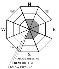
The avalanche danger is LOW for most aspects and elevations. Blustery, west/northwest wind in exposed, alpine terrain above treeline is forecast today. MODERATE wind slab danger is possible above treeline on easterly aspects and some northerly and southerly, cross-loaded aspects. Large wind slab avalanches are unlikely; small wind slabs are possible in isolated or extreme terrain at higher elevations.


Avalanche Problem 1: Wind Slab
-
Character ?

-
Aspect/Elevation ?
-
Likelihood ?CertainVery LikelyLikelyPossible
 Unlikely
 -
Size ?HistoricVery LargeLargeSmall

Above treeline in alpine terrain is your best chance at encountering a wind slab today. Moderate wind out of the west/northwest will blow 20-30 mi/hr. Pay attention to the wind and any potential snow available for transport. Existing wind slab danger has largely settled out, though new wind slabs are possible in higher elevation, steep, extreme alpine terrain. Look for wind slabs on easterly aspects or cross loaded aspects facing north and south. Shooting cracks and blocking snow along with visible blowing snow is one of the best sign(s) of a wind slab problem. Stick to windward aspects for the safest travel in avalanche terrain.
Forecast Discussion
With a 14,179 foot peak sticking up thousands of feet higher than any other surrounding terrain, there is no argument wind is a factor in regard to avalanche danger. Heck...wind blowing snow is one of the five red flags of avalanche danger! With that said, we feel like we have run into message fatigue with the wind slab avalanche problem. Notable wind slab avalanches have been few this season, but it's constantly on our mind. Wind slabs are relatively easy to predict as far as location, but much more difficult to predict in terms of sensitivity to triggering. Hard wind slabs can pop off without warning and even small slabs can send a skier or rider down the slope. Remain vigilant to the wind slab problem, especially in higher elevation terrain above treeline and in other alpine terrain in the Eddies, Castle Lake and east of Mt Shasta.
Recent Observations
- Temperatures have ranged from 24 to 41 degrees F in the last 24 hours at treeline.
- Wind at 8,000 feet - Avg: 14 mi/hr - Max: 22 mi/hr - Min: 5 mi/hr - Direction: West/Northwest
- Snow depth averages 70 inches (177.8 cm) on Mount Shasta, 36 inches (91.44 cm) in the Castle Lake area and 80 inches (203 cm) near Ash Creek Butte/East Side areas.
- No new snow
- A public observation noted a small wind slab avalanche off Casaval Ridge, near Spring Hill along with whumpfing in low angle terrain, climbers gully, above treeline (9,000 to 10,400 feet)
- Wind drifts up to 2 feet (61 centimeters) deep
Weather and Current Conditions
Weather Summary
Not to be a Debbie Downer, but there are no big dumps in the forecast for the near or extended future. Fortunately, I'm not in charge of the weather. A couple warm and cold fronts will pass through the area over the course of the next couple days. No precipitation is expected aside from a few fleeting showers here and there, with little to no accumulation. A strong cold front will push onshore Saturday night bringing an abrupt transition in temps, nearly 10 degrees below normal. Snow levels will drop from 7,000 feet to 1,000 feet Sunday morning. Precipitation will be light for the most part and finished up by Monday morning. High pressure builds Monday, Tuesday and begins to warm into Wednesday. Meh...
24 Hour Weather Station Data @ 4:00 AM
| Weather Station | Temp (°F) | Wind (mi/hr) | Snow (in) | Comments | ||||||||
|---|---|---|---|---|---|---|---|---|---|---|---|---|
| Cur | Min | Max | Avg | Avg | Max Gust | Dir | Depth | New | Water Equivalent | Settlement | ||
| Mt. Shasta City (3540 ft) | 37 | 30 | 47 | 39.5 | 1 | N | ||||||
| Sand Flat (6750 ft) | 35 | 24 | 40 | 34 | 53 | 0 | 0 | 1 | ||||
| Ski Bowl (7600 ft) | 33 | 24 | 41 | 33.5 | 70 | 0 | 0.01 | 1 | ||||
| Gray Butte (8000 ft) | 32.5 | 23.5 | 35 | 32 | 13 | 37 | WNW | |||||
| Castle Lake (5870 ft) | 0 | 0 | 0 | 0 | 0 | 0 | 0 | down | ||||
| Mount Eddy (6509 ft) | 34 | 32 | 40 | 37 | 1 | 9 | SE | 45.3 | 0 | 2 | ||
| Ash Creek Bowl (7250 ft) | down | |||||||||||
| Ash Creek Ridge (7895 ft) | down |
Two Day Mountain Weather Forecast
Produced in partnership with the Medford NWS
| For 7000 ft to 9000 ft | |||
|---|---|---|---|
|
Thursday (4 a.m. to 10 p.m.) |
Thursday Night (10 p.m. to 4 a.m.) |
Friday (4 a.m. to 10 p.m.) |
|
| Weather | Mostly cloudy this morning, partly cloudy this afternoon. Slight chance of rain and snow showers. Snow level near 7,300 feet. | Partly to mostly cloudy. | Partly cloudy to mostly sunny. |
| Temperature (°F) | 42 | 39 | 48 |
| Wind (mi/hr) | Northwest 5-10 | Variable 0-5 | Variable 0-5 |
| Precipitation SWE / Snowfall (in) | 0.00 / 0 | 0.00 / 0 | 0.00 / 0 |
| For 9000 ft to 11000 ft | |||
| Thursday | Thursday Night | Friday | |
| Weather | Mostly cloudy this morning, partly cloudy this afternoon. Slight chance of rain and snow showers. Windy. | Partly to mostly cloudy. Windy. | Partly cloudy to mostly sunny. Windy. |
| Temperature (°F) | 29 | 29 | 36 |
| Wind (mi/hr) | Northwest 20-30 | Northwest 10-20 | West 10-20 |
| Precipitation SWE / Snowfall (in) | 0.00 / 0 | 0.00 / 0 | 0.00 / 0 |
Season Precipitation for Mount Shasta City
| Period | Measured (in) | Normal (in) | Percent of Normal (%) |
|---|---|---|---|
| From Oct 1, 2025 (the wet season) | 12.78 | 21.85 | 58 |
| Month to Date (since Jun 1, 2026) | 3.85 | 6.64 | 58 |
| Year to Date (since Jan 1, 2026) | 3.85 | 6.64 | 58 |

