

You are here
Avalanche Forecast for 2020-02-18 06:30
- EXPIRED ON February 19, 2020 @ 6:30 amPublished on February 18, 2020 @ 6:30 am
- Issued by Ryan Sorenson - Mount Shasta Avalanche Center
Bottom Line
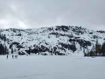
The snowpack is variable, and mostly firm surfaces remain. Avalanche danger is LOW. Use an ice axe, crampons, and helmet if ascending steep terrain. Beware of falling rock. Light winds and warm temperatures will allow for spring-like melt-freeze conditions in sun-exposed areas.


Avalanche Problem 1: Normal Caution
-
Character ?

-
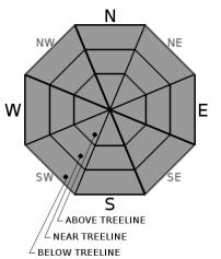
Aspect/Elevation ?
-
Likelihood ?CertainVery LikelyLikelyPossible
 Unlikely
 -
Size ?HistoricVery LargeLargeSmall

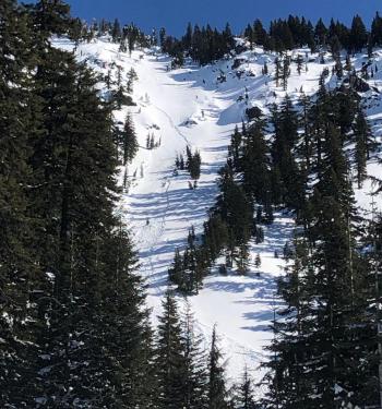
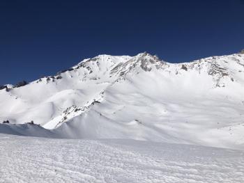
Calm wind and warming temperatures should allow snow surfaces to soften on solar aspects by midday. Firm and variable surface conditions present hazards like long sliding falls that potentially terminate in rocky patches in steep alpine terrain. Use an ice axe, crampons, and helmet if ascending steep slopes. Solar radiation and warmer temperatures may loosen the hold the snowpack has on rocks. Beware of rockfall above treeline on Mount Shasta, especially above Helen Lake and areas along Casaval Ridge due to large patches of exposed rock.
Recent Observations
- In the last 24 hours, Mount Shasta has received no new snow.
- Temperatures have been mostly below freezing. Temperatures poked above freezing, only briefly reaching a high of 33 deg F at 11 AM.
- Winds have died off and become light and variable.
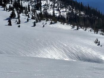
- The snowpack is firm and consolidated with variable surface textures.
- Shallow, firm, and old wind textured snow with icy patches remain.
- Dirt and cinders blown from bare patches at higher elevations have collected in depressions and gullies.
- No recent signs of instability.
Weather and Current Conditions
Weather Summary
Calm wind and a trend of warming temperatures have set in due to a thick high-pressure ridge perched off the coast. Dry, clear weather accompanied by cold nights (low 20's) and relatively warm days (high 30's / low 40's) at mid-elevations will continue this week. The calmest winds are expected today and could allow for an extended window of softer snow surfaces.
Cool and showery weather will return this weekend.
24 Hour Weather Station Data @ 6:00 AM
| Weather Station | Temp (°F) | Wind (mi/hr) | Snow (in) | Comments | ||||||||
|---|---|---|---|---|---|---|---|---|---|---|---|---|
| Cur | Min | Max | Avg | Avg | Max Gust | Dir | Depth | New | Water Equivalent | Settlement | ||
| Mt. Shasta City (3540 ft) | 24 | 23 | 47 | 33.5 | 3 | N | ||||||
| Sand Flat (6750 ft) | 19 | 18 | 36 | 27 | 48 | 0 | 0 | 0 | ||||
| Ski Bowl (7600 ft) | 22.5 | 20 | 33 | 27 | 64 | 0 | 0 | 0 | ||||
| Gray Butte (8000 ft) | 25 | 20 | 31.5 | 26.5 | 11 | 55 | N | |||||
| Castle Lake (5870 ft) | 24 | 23.5 | 33 | 27 | 30 | 0 | 0 | |||||
| Mount Eddy (6509 ft) | 19 | 18.5 | 29 | 24 | 3 | 16 | WSW | 46 | 0 | 0 | ||
| Ash Creek Bowl (7250 ft) | down | |||||||||||
| Ash Creek Ridge (7895 ft) | down |
Two Day Mountain Weather Forecast
Produced in partnership with the Medford NWS
| For 7000 ft to 9000 ft | |||
|---|---|---|---|
|
Tuesday (4 a.m. to 10 p.m.) |
Tuesday Night (10 p.m. to 4 a.m.) |
Wednesday (4 a.m. to 10 p.m.) |
|
| Weather | Sunny. | Clear. | Sunny. |
| Temperature (°F) | 40 | 19 | 41 |
| Wind (mi/hr) | Northeast 0-5 | Northeast 0-5 | East 5-10 |
| Precipitation SWE / Snowfall (in) | 0.00 / 0 | 0.00 / 0 | 0.00 / 0 |
| For 9000 ft to 11000 ft | |||
| Tuesday | Tuesday Night | Wednesday | |
| Weather | Sunny. | Clear | Sunny. |
| Temperature (°F) | 23 | 18 | 20 |
| Wind (mi/hr) | Northwest 10-15 | West 5-10 | Southeast 10-15 |
| Precipitation SWE / Snowfall (in) | 0.00 / 0 | 0.00 / 0 | 0.00 / 0 |
Season Precipitation for Mount Shasta City
| Period | Measured (in) | Normal (in) | Percent of Normal (%) |
|---|---|---|---|
| From Oct 1, 2025 (the wet season) | 12.90 | 26.49 | 49 |
| Month to Date (since Jun 1, 2026) | 0.12 | 4.22 | 3 |
| Year to Date (since Jan 1, 2026) | 3.97 | 11.28 | 35 |

