

You are here
Avalanche Forecast for 2020-03-07 06:37
- EXPIRED ON March 8, 2020 @ 7:37 amPublished on March 7, 2020 @ 6:37 am
- Issued by Nick Meyers - Shasta-Trinity National Forest
Bottom Line
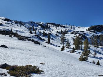
Snow showers will continue today with a southwesterly breeze. Watch for wind blowing snow and pay attention to where the snow is headed. Small, fresh wind slabs are possible in leeward N-NE-E facing terrain, near/above treeline. Wind slabs will likely not be big enough to bury you, but none-the-less, keep an eye out for areas where wind loading may have occurred.


Avalanche Problem 1: Wind Slab
-
Character ?

-
Aspect/Elevation ?
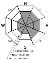
-
Likelihood ?CertainVery LikelyLikelyPossible
 Unlikely
 -
Size ?HistoricVery LargeLargeSmall

New snow accumulation and wind speeds have been unremarkable this morning. Higher on the mountain could be different. For the day, keep watch for wind blowing snow near and above treeline. Southwesterly wind is forecast to blow 15-25 mi/hr today at 10,000 feet. Leeward N-NE-E facing slopes may host the best wind loading, but not limited too. Mount Shasta is very good at creating funky wind eddies and one might experience wind from a completely different direction. Wind slabs are not expected to be of significant size, but that doesn't mean you should throw caution out the door. Precipitation and wind will gradually die off over the next 24 hours.
Recent Observations
Yesterday observed gradually increasing clouds throughout the day and breezy conditions. Snow surfaces struggled to soften. Needless to say, the snowpack is set up well for new snow. Warm temps have allowed good bonding of old and new snow. Snow began to fall at midnight last night. The Old Ski Bowl weather station has recorded .18" of SWE at 0600 hours. While it's obviously snowing up there, the snow depth sensors have indicated very little accumulation. Temperatures hovered in the mid-twenties. Since the storm onset, southwesterly wind has averaged 8 mi/hr with gusts to 16 mi/hr over the past 6 hours.
Weather and Current Conditions
Weather Summary
We are in the middle of a light duty winter storm this morning, the first precipitation that we've seen in over a MONTH. Painful to say, so I'll only say it once more: February was the driest on record (since 1948) and we haven't seen any water since February 2nd.
A winter weather advisory remains in effect above 3,500 feet for the Mount Shasta area today. Expect snow to continue this morning, gradually fading throughout the day. Snow levels will linger near 3,700 feet. Showers appear to linger Sunday and Monday, though significant accumulation is not expected. Wind speeds will be light below treeline and moderate near and above treeline, southwesterly. High pressure will return next week.
24 Hour Weather Station Data @ 5:00 AM
| Weather Station | Temp (°F) | Wind (mi/hr) | Snow (in) | Comments | ||||||||
|---|---|---|---|---|---|---|---|---|---|---|---|---|
| Cur | Min | Max | Avg | Avg | Max Gust | Dir | Depth | New | Water Equivalent | Settlement | ||
| Mt. Shasta City (3540 ft) | 33 | 33 | 52 | 43.5 | 3 | N | ||||||
| Sand Flat (6750 ft) | 30 | 30 | 39 | 34 | 39 | 2 | 0 | |||||
| Ski Bowl (7600 ft) | 25.5 | 25.5 | 36.5 | 30.5 | 58 | 2 | 0.13 | 0 | ||||
| Gray Butte (8000 ft) | 24.5 | 24.5 | 32 | 28 | 8 | 31 | SSW | |||||
| Castle Lake (5870 ft) | 30 | 30 | 41 | 35 | 24.4 | 1 | 0 | |||||
| Mount Eddy (6509 ft) | 28 | 28 | 37.5 | 33 | 2 | 13 | SSW | 43.6 | 1 | 0 | ||
| Ash Creek Bowl (7250 ft) | down | |||||||||||
| Ash Creek Ridge (7895 ft) | down |
Two Day Mountain Weather Forecast
Produced in partnership with the Medford NWS
| For 7000 ft to 9000 ft | |||
|---|---|---|---|
|
Saturday (4 a.m. to 10 p.m.) |
Saturday Night (10 p.m. to 4 a.m.) |
Sunday (4 a.m. to 10 p.m.) |
|
| Weather | Snow before 10AM, then snow showers mainly between 10AM and 4PM. Snow level near 3,700 feet. | Chance of snow showers before 10PM. Mostly cloudy. Snow levels near 2,500 feet. | Mostly cloudy. Slight chance of snow showers. Snow level near 3,500 feet. |
| Temperature (°F) | 28 | 22 | 31 |
| Wind (mi/hr) | Southwest 5-10 | South 0-5 | South 5-10 |
| Precipitation SWE / Snowfall (in) | 0.47 / 3-6 | 0.04 / 0 | 0.01 / 0 |
| For 9000 ft to 11000 ft | |||
| Saturday | Saturday Night | Sunday | |
| Weather | Snow before 10AM, then show showers between 10AM and 4PM. Breezy. | Chance of snow showers, mainly before 10PM. Mostly cloudy. | Slight chance of snow showers, mostly cloudy. |
| Temperature (°F) | 12 | 10 | 15 |
| Wind (mi/hr) | Southwest 15-25 | Southwest 10-15 | South 15-20 |
| Precipitation SWE / Snowfall (in) | 0.47 / 4-7 | 0.04 / 0-1 | 0.01 / 0 |
Season Precipitation for Mount Shasta City
| Period | Measured (in) | Normal (in) | Percent of Normal (%) |
|---|---|---|---|
| From Oct 1, 2025 (the wet season) | 13.04 | 31.00 | 42 |
| Month to Date (since Jun 1, 2026) | 0.14 | 1.50 | 9 |
| Year to Date (since Jan 1, 2026) | 4.11 | 15.79 | 26 |

