

You are here
Avalanche Forecast for 2020-03-08 06:30
- EXPIRED ON March 9, 2020 @ 6:30 amPublished on March 8, 2020 @ 6:30 am
- Issued by Ryan Sorenson - Mount Shasta Avalanche Center
Bottom Line
Triggering a small wind slab avalanche remains possible on N-NE-E facing slopes above treeline this morning. Avalanche danger is MODERATE above treeline with LOW avalanche danger existing below and near treeline. Increasing temperatures with decreasing winds will reduce the possibility of triggering an avalanche this afternoon. The shallow new snow barely covers previously exposed obstacles at lower elevations.


Avalanche Problem 1: Wind Slab
-
Character ?

-
Aspect/Elevation ?
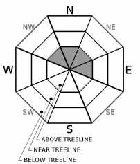
-
Likelihood ?CertainVery LikelyLikelyPossible
 Unlikely
 -
Size ?HistoricVery LargeLargeSmall

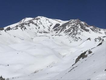
Three to five inches of fresh snow fell Friday night/Saturday morning. Westerly winds have been moderate, and wind slab formation has been observed on east-facing above treeline terrain on Mount Shasta. Triggering a small wind slab may remain possible on N-NE-E aspects above treeline this morning. Wind slabs will likely not be big enough to bury you. None-the-less, keep an eye out for areas where wind loading may have occurred. Decreasing winds and warming temperatures today will reduce the likelihood of triggering a wind slab avalanche today.
Continue to identify areas where wind drifted snow is being deposited. Isolated areas below cornices and where pillows of deeper wind drifted snow remains is most suspect. Adjust your travel plans to avoid these areas of concern.
Forecast Discussion
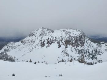
Use caution as many obstacles, such as rocks, bushes, and logs, remain barely hidden under the new snow.
Recent Observations
In the last 24 hours on Mount Shasta, temperatures have ranged from 19 to 25 °F. Above treeline, northwesterly winds were moderate to strong, averaging 12 mi/hr at 8,000 feet.
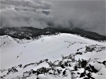
Brief periods of light snow showers continued throughout the morning. Below and near treeline, the new snow barely covers old pockmarks, rocks, and bushes as three to five inches of fresh snow sit atop a firm and consolidated snowpack. The Old Ski Bowl weather station has recorded 3 inches and .48" of SWE since Friday night.
Above treeline, productive westerly winds were blowing snow, loading N-NE-E facing terrain. The new snow is light and easily transported. Some minor blocking and cracking were observed along easterly facing slopes on Green Butte Ridge. A small wind slab was triggered near the top of Powder Bowl, failing on a density change 6 inches deep. This avalanche was relatively small and inconsequential, but it was big enough to sweep an unaware skier off their feet. See the observation below for more details.
Weather and Current Conditions
Weather Summary
Optimistically speaking, we may see up to an inch of new snow above 4,000 feet today and tonight as this light winter storm lingers. The majority of the precipitation has already been squeezed out, but overcast skies and a slight chance of snow showers will continue until Tuesday. Winds are currently decreasing and will be light to moderate, switching from the north to south.
Clear weather will arrive on Tuesday. A pattern of cold nights and warm days will continue throughout the week. Expect another winter storm next weekend.
24 Hour Weather Station Data @ 6:00 AM
| Weather Station | Temp (°F) | Wind (mi/hr) | Snow (in) | Comments | ||||||||
|---|---|---|---|---|---|---|---|---|---|---|---|---|
| Cur | Min | Max | Avg | Avg | Max Gust | Dir | Depth | New | Water Equivalent | Settlement | ||
| Mt. Shasta City (3540 ft) | 35 | 32 | 40 | 36 | 1 | N | ||||||
| Sand Flat (6750 ft) | 25 | 25 | 32 | 28 | 39 | 0 | 0 | 0 | ||||
| Ski Bowl (7600 ft) | 20.5 | 20.5 | 30 | 24 | 60.6 | 2.6 | .35 | 0 | ||||
| Gray Butte (8000 ft) | 18.5 | 18.5 | 25.5 | 21.5 | 12 | 31 | WNW | |||||
| Castle Lake (5870 ft) | 26 | 26 | 37.5 | 30 | 29.7 | 5.3 | 0 | |||||
| Mount Eddy (6509 ft) | 24 | 23 | 29.5 | 26 | 1 | 7 | E | 45.8 | 2.7 | 0 | ||
| Ash Creek Bowl (7250 ft) | down | |||||||||||
| Ash Creek Ridge (7895 ft) | down |
Two Day Mountain Weather Forecast
Produced in partnership with the Medford NWS
| For 7000 ft to 9000 ft | |||
|---|---|---|---|
|
Sunday (4 a.m. to 10 p.m.) |
Sunday Night (10 p.m. to 4 a.m.) |
Monday (4 a.m. to 10 p.m.) |
|
| Weather | Mostly cloudy. Slight chance of light snow showers. Snow level near 3,700 feet and rising. | Mostly cloudy. 40 percent chance of light snow showers after 6 PM. Snow level near 4600 feet lowering to 3,800 feet. | Mostly cloudy. Slight chance of light snow showers before 10 AM. Snow level near 3,700 feet and rising. |
| Temperature (°F) | 30 | 25 | 36 |
| Wind (mi/hr) | South 5-10 | South 0-5 | South 5-10 |
| Precipitation SWE / Snowfall (in) | 0.01 / 0-0.50 | 0.02 / 0-1 | 0.01 / 0-0.50 |
| For 9000 ft to 11000 ft | |||
| Sunday | Sunday Night | Monday | |
| Weather | Mostly cloudy. Slight chance of light snow showers. | Mostly cloudy. Chance of snow showers after 6 PM. | Mostly cloudy. Slight chance of light snow showers. |
| Temperature (°F) | 17 | 14 | 17 |
| Wind (mi/hr) | South 20-25 | Southwest 10-15 | Southwest 5-10 |
| Precipitation SWE / Snowfall (in) | 0.01 / 0-0.50 | 0.02 / 0-1 | 0.01 / 0-0.50 |
Season Precipitation for Mount Shasta City
| Period | Measured (in) | Normal (in) | Percent of Normal (%) |
|---|---|---|---|
| From Oct 1, 2025 (the wet season) | 13.57 | 31.23 | 43 |
| Month to Date (since Jun 1, 2026) | 0.67 | 1.73 | 39 |
| Year to Date (since Jan 1, 2026) | 4.64 | 16.02 | 29 |

