

You are here
Avalanche Forecast for 2020-03-28 06:26
- EXPIRED ON March 29, 2020 @ 6:26 amPublished on March 28, 2020 @ 6:26 am
- Issued by Nick Meyers - Shasta-Trinity National Forest
Bottom Line
LOW hazard does not mean, no hazard. Be on watch for isolated wind slabs near and above treeline that may form during this weekends snowfall events. Size and distribution is expected to be small. Light to moderate wind will blow out of the south/southwest. Below treeline, the snowpack is stable and avalanches are unlikely. Watch for shallow buried objects.


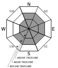
Avalanche Problem 1: Wind Slab
-
Character ?

-
Aspect/Elevation ?
-
Likelihood ?CertainVery LikelyLikelyPossible
 Unlikely
 -
Size ?HistoricVery LargeLargeSmall

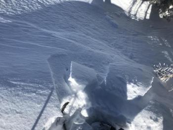
In near and above treeline terrain, watch for new wind slabs that may form due to south/west/northwest wind and a few inches of new snow. Slabs could exist near ridge crests, cliff areas and/or near the rim of bowl features. Expected size is small. Remember that even small slides can carry consequences in unforgiving terrain. Slabs can become more sensitive in areas that are rapidly warmed by increasing temperatures and direct sunlight. Look for wind blowing snow. Pay attention to cracks that may occur when stomping on small, test slopes.
Forecast Discussion
Bunny Flat trailhead remains open. Pack it in, pack it out. Trash service is not available. Use the restrooms at your own risk. They are cleaned 1-2 times per week. Handwashing is NOT available. Bring your own sanitizer. Maintain physical distance at all times. Shelter-in-place orders are state wide, though we recognize the need for a little fresh air. Recreate responsibly, please. More information here.
Recent Observations
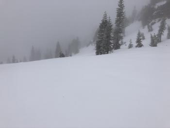
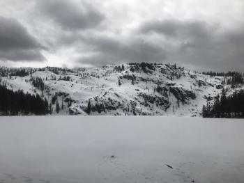
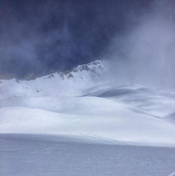
Yesterday, the sky was mostly obscured with a few shy, blue bits poking through for moments. Overall, increasing clouds and snow flurries hosted the day. Little snow accumulation was recorded (.07' SWE). Winds have averaged 9 mi/hr with gusts to 18 mi/hr out of the west/northwest. Temperatures at treeline maxed at 30F, with a low of 20F. Snow surfaces are variable. Soft snow can be found on northerly aspects. Aspects south and west had a breakable melt/freeze crust. Minor wind affected snow is found above treeline. Middle Peak at Castle Lake still has a usable, moist snowpack. The lake is frozen and supportable. Be cautious for weak ice near the edges. Right and Left Peak are mostly melted out. Aside from a few small, shallow wind slabs, no obvious signs of avalanche danger have been observed within the forecast area.
Weather and Current Conditions
Weather Summary
The weekend will be a slow trickle of weather. This will include snow showers in the mountains and rain in the valleys. Snow levels will rest in the 4,000 to 5,000 foot range. About .5 inches of snow/water equivalent is expected, which could mean 3-6 inches of fresh snow by next week. Light wind is forecast for the weekend, picking up speed on Monday out of the west/northwest. High and low temperatures will remain fairly static for the time being.
24 Hour Weather Station Data @ 4:00 AM
| Weather Station | Temp (°F) | Wind (mi/hr) | Snow (in) | Comments | ||||||||
|---|---|---|---|---|---|---|---|---|---|---|---|---|
| Cur | Min | Max | Avg | Avg | Max Gust | Dir | Depth | New | Water Equivalent | Settlement | ||
| Mt. Shasta City (3540 ft) | 37 | 28 | 49 | 41 | 1 | N | ||||||
| Sand Flat (6750 ft) | 26 | 21 | 33 | 28 | 44 | .5 | 0 | 1 | ||||
| Ski Bowl (7600 ft) | 22 | 20 | 30 | 24 | 73.2 | 1 | 0.07 | 0 | ||||
| Gray Butte (8000 ft) | 21 | 19.5 | 26.5 | 22.5 | 9 | 18 | W | |||||
| Castle Lake (5870 ft) | 27.5 | 24.5 | 43.5 | 31.5 | 36.6 | .5 | 1 | |||||
| Mount Eddy (6509 ft) | 26 | 20 | 32 | 27.5 | 1 | 8 | E | 56.6 | .5 | 2 | ||
| Ash Creek Bowl (7250 ft) | down | |||||||||||
| Ash Creek Ridge (7895 ft) | down |
Two Day Mountain Weather Forecast
Produced in partnership with the Medford NWS
| For 7000 ft to 9000 ft | |||
|---|---|---|---|
|
Saturday (4 a.m. to 10 p.m.) |
Saturday Night (10 p.m. to 4 a.m.) |
Sunday (4 a.m. to 10 p.m.) |
|
| Weather | Snow showers likely. Snow level near 4,600 feet | Rain and snow showers likely in the evening. Snow showers after midnight. Snow level near 4,900 feet | Snow showers in the morning, then rain and snow showers in the afternoon. Snow level near 4,600 feet |
| Temperature (°F) | 30 | 27 | 31 |
| Wind (mi/hr) | South 0-5 | South 0-5 | South 5-10 |
| Precipitation SWE / Snowfall (in) | 0.10 / 1-2 | 0.14 / 1-3 | 0.16 / 1-3 |
| For 9000 ft to 11000 ft | |||
| Saturday | Saturday Night | Sunday | |
| Weather | Snow showers likely, cloudy. | Snow showers. | Snow showers |
| Temperature (°F) | 14 | 12 | 16 |
| Wind (mi/hr) | South 0-5 | Southwest 5-10 | Southwest 10-15 |
| Precipitation SWE / Snowfall (in) | 0.10 / 1-3 | 0.14 / 2-4 | 0.16 / 2-4 |
Season Precipitation for Mount Shasta City
| Period | Measured (in) | Normal (in) | Percent of Normal (%) |
|---|---|---|---|
| From Oct 1, 2025 (the wet season) | 14.95 | 34.93 | 43 |
| Month to Date (since Jul 1, 2026) | 2.05 | 5.43 | 38 |
| Year to Date (since Jan 1, 2026) | 6.02 | 19.72 | 31 |

