

You are here
Avalanche Forecast for 2020-03-31 06:40
- EXPIRED ON April 1, 2020 @ 6:40 amPublished on March 31, 2020 @ 6:40 am
- Issued by Ryan Sorenson - Mount Shasta Avalanche Center
Bottom Line
North and west winds are expected to transport snow and continue to load leeward aspects above treeline over the next 24 hours. Human triggered avalanches remain possible. Intense solar radiation may also weaken snow surfaces and cause minor wet loose avalanche activity below and near treeline.


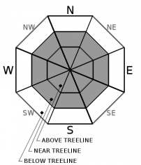
Avalanche Problem 1: Wind Slab
-
Character ?

-
Aspect/Elevation ?
-
Likelihood ?CertainVery LikelyLikelyPossible
 Unlikely
 -
Size ?HistoricVery LargeLargeSmall

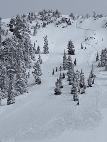
Lower elevation zones yesterday indicated moist and heavy snow surfaces. Though little concern for wind slabs has been observed recently, observations at higher elevations have been limited. Wind speeds today look to be productive, especially in the afternoon. If you are thinking of going high and getting into some avalanche terrain, evaluate snow and wind carefully. Triggering a large wind slab in steep near and above treeline terrain remains possible.
Identify where wind slabs may exist by looking for wind-scoured ridges, new cornice development, pillows of wind drifted snow and other wind-sculpted features on the snow surface. Try to figure out the local direction of the wind from these clues and identify areas where loading has occurred. Winds slabs are often lens-shaped and hollow sounding. Shooting cracks, whumping, and blocking indicate a nearby wind slab problem. Avoid them by sticking to protected or wind-scoured areas.
Avalanche Problem 2: Loose Wet
-
Character ?

-
Aspect/Elevation ?
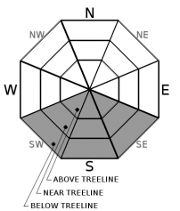
-
Likelihood ?CertainVery LikelyLikelyPossible
Unlikely
-
Size ?HistoricVery LargeLargeSmall
Fresh snow and warming temperatures causes some concern for loose wet avalanche activity. There are many clues that loose wet avalanches are likely. On small, steep test slopes, the surface layers will slide easily. Fresh roller balls–little snowballs–falling off trees and cliff bands indicate that the snowpack surface is getting weak. These slides may not be large enough to bury you, but could gain size on large slopes.
Forecast Discussion
Conditions are dynamic today, and a level of uncertainty remains. With the new snow, wet snow, wind transporting snow, and possible sunshine a heightened awareness of avalanches is necessary. Pay attention to the five red flags of avalanche danger and adjust your travel plans to avoid areas of concern.
Five red flags of avalanche danger:
- Recent avalanches
- New snow
- Collapsing, cracking, or blocking
- Blowing snow
- Rapid temperature rise
Recent Observations
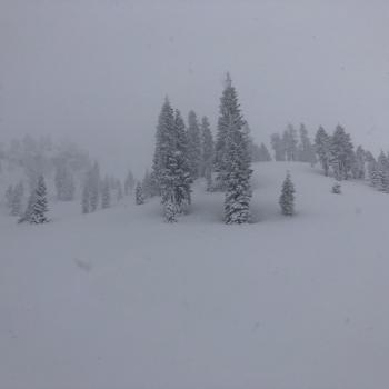
Very low visibility and moist heavy snow was observed below and near treeline yesterday. The snowpack host a slightly upside-down configuration with heavy moist snow above drier snow separated with a thin melt-freeze crust. Snowpits dug in Old Ski Bowl had resistant results with some planar failures occurring near crust layers 4 and 12 inches (11 and 30 cm) deep. Snow surfaces were unaffected by the wind. With such low visibility, conditions above treeline were difficult to evaluate.
In the last 24 hours:
- Snow accumulation of 4 inches (.64' SWE) was recorded at the Old Ski Bowl Weather station.
- Winds have averaged 15 mi/hr with gusts to 31 mi/hr out of the west/northwest.
- Temperatures at treeline maxed at 29F, with a low of 24F.
Weather and Current Conditions
Weather Summary
Expect more low clouds, mist and foggy weather this morning. Lingering snow showers could accumulate up to an inch of snow. Skies should begin to clear late this afternoon. Breezy, light winds out of the southwest will increase and switch to a more northwesterly flow as the storm moves further inland.
Clear and cold weather will set in tonight and is expected to hold throughout the week. Another round of stormy weather will arrive Friday night. The forecasting models are still working out exactly how much moisture will push into our area. None the less, we should see a decent amount of snow above 6,000 feet this weekend.
24 Hour Weather Station Data @ 6:00 AM
| Weather Station | Temp (°F) | Wind (mi/hr) | Snow (in) | Comments | ||||||||
|---|---|---|---|---|---|---|---|---|---|---|---|---|
| Cur | Min | Max | Avg | Avg | Max Gust | Dir | Depth | New | Water Equivalent | Settlement | ||
| Mt. Shasta City (3540 ft) | 41 | 39 | 46 | 43 | 3 | |||||||
| Sand Flat (6750 ft) | 31 | 28 | 32 | 31 | 49 | 1 | 0 | 0 | ||||
| Ski Bowl (7600 ft) | 28 | 24 | 29 | 27 | 83 | 4 | 0.64 | 0 | ||||
| Gray Butte (8000 ft) | 27 | 23.5 | 28 | 26.5 | 15 | 31 | W | |||||
| Castle Lake (5870 ft) | 31.5 | 29 | 36.5 | 33 | 38.9 | 0.5 | 0 | |||||
| Mount Eddy (6509 ft) | 30.5 | 27 | 36 | 31 | 1 | 12 | S | 58.9 | 1.6 | 0 | ||
| Ash Creek Bowl (7250 ft) | down | |||||||||||
| Ash Creek Ridge (7895 ft) | down |
Two Day Mountain Weather Forecast
Produced in partnership with the Medford NWS
| For 7000 ft to 9000 ft | |||
|---|---|---|---|
|
Tuesday (4 a.m. to 10 p.m.) |
Tuesday Night (10 p.m. to 4 a.m.) |
Wednesday (4 a.m. to 10 p.m.) |
|
| Weather | Breezy, cloudy. Snow showers in the morning, then snow possible in the afternoon. Snow level near 5,400 feet | Mostly clear. | Sunny. |
| Temperature (°F) | 36 | 18 | 32 |
| Wind (mi/hr) | Southwest 10-15 | Northwest 10-15 | North 5-10 |
| Precipitation SWE / Snowfall (in) | 0.09 / 0-1 | 0.00 / 0 | 0.00 / 0 |
| For 9000 ft to 11000 ft | |||
| Tuesday | Tuesday Night | Wednesday | |
| Weather | Breezy, cloudy. Snow showers in the morning, then snow possible in the afternoon. | Mostly clear. | Sunny |
| Temperature (°F) | 19 | 10 | 11 |
| Wind (mi/hr) | West 35-40 | West 25-30 | North 10-15 |
| Precipitation SWE / Snowfall (in) | 0.09 / 0-2 | 0.00 / 0 | 0.00 / 0 |
Season Precipitation for Mount Shasta City
| Period | Measured (in) | Normal (in) | Percent of Normal (%) |
|---|---|---|---|
| From Oct 1, 2025 (the wet season) | 15.03 | 35.33 | 43 |
| Month to Date (since Jul 1, 2026) | 2.13 | 5.83 | 37 |
| Year to Date (since Jan 1, 2026) | 6.10 | 20.12 | 30 |

