

You are here
Avalanche Forecast for 2020-04-01 05:30
- EXPIRED ON April 2, 2020 @ 5:30 amPublished on April 1, 2020 @ 5:30 am
- Issued by Aaron Beverly - Mount Shasta Avalanche Center
Bottom Line
Avalanche danger is MODERATE above treeline. Evaluate terrain and wind carefully. Wind slab avalanches are possible on steep leeward terrain. It'll be a sunny, cold day. Wintry weather returns Saturday.


Avalanche Problem 1: Wind Slab
-
Character ?

-
Aspect/Elevation ?
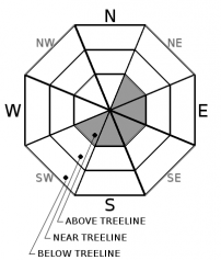
-
Likelihood ?CertainVery LikelyLikelyPossible
 Unlikely
 -
Size ?HistoricVery LargeLargeSmall

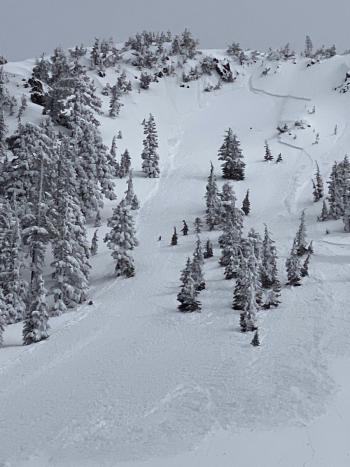
A period of warming followed by dropping temperatures has made avalanches less likely near and below treeline. However, west and northwest winds have been moderate making wind slab avalanches possible above treeline. Natural avalanches occurred Monday night. Easterly facing slopes are the most suspect.
If you are going high, pay attention to steep leeward slopes and blowing snow. There may be some wind slabs out there. If you find them, they'll be lens shaped, at the top of start zones, and will crack under your feet. Test for them on rollovers above areas of no consequence.
Forecast Discussion
Don't be complacent. Winter still lingers. Pay attention to the 5 red flags of avalanche danger:
- Recent avalanches
- New snow
- Collapsing, cracking, or blocking
- Blowing snow
- Rapid temperature rise
Recent Observations
In the last 24 hours, a trace amount of snow fell near treeline on Mount Shasta. West and northwest winds were moderate, peaking at 19 mi/hr. Temperatures rose above freezing for a few hours in the afternoon but have been dropping precipitously overnight bottoming out at 16 degrees.
Though visibility was brief and limited, it appeared that a few small, natural, wind-slab avalanches (D1/R1) occurred on east facing aspects late Monday night. A skier-triggered avalanche occurred on Sunday afternoon on a northwest aspect of Gray Butte.
Weather and Current Conditions
Weather Summary
Cold and clear conditions will prevail over the next couple of days with snow levels below 3,000 ft, though no snow is expected. Northerly winds will be light to moderate.
Wet weather returns this weekend with over an inch of precipitable water expected. Stay tuned for snow levels ....
24 Hour Weather Station Data @ 3:00 AM
| Weather Station | Temp (°F) | Wind (mi/hr) | Snow (in) | Comments | ||||||||
|---|---|---|---|---|---|---|---|---|---|---|---|---|
| Cur | Min | Max | Avg | Avg | Max Gust | Dir | Depth | New | Water Equivalent | Settlement | ||
| Mt. Shasta City (3540 ft) | 41 | 39 | 46 | 43 | 3 | |||||||
| Sand Flat (6750 ft) | 19 | 19 | 39 | 31 | 49 | 0 | 0 | 0 | ||||
| Ski Bowl (7600 ft) | 19 | 16.5 | 34 | 26.5 | 82.7 | 0 | 0.17 | 0.7 | ||||
| Gray Butte (8000 ft) | 17 | 17 | 33.5 | 25.5 | 17 | 31 | WNW | |||||
| Castle Lake (5870 ft) | 20.5 | 20.5 | 47 | 32.5 | 0 | 0 | 0 | |||||
| Mount Eddy (6509 ft) | 19 | 19 | 41 | 30 | 1 | 9 | SE | 58.7 | 0.4 | 0 | ||
| Ash Creek Bowl (7250 ft) | down | |||||||||||
| Ash Creek Ridge (7895 ft) | down |
Two Day Mountain Weather Forecast
Produced in partnership with the Medford NWS
| For 7000 ft to 9000 ft | |||
|---|---|---|---|
|
Wednesday (4 a.m. to 10 p.m.) |
Wednesday Night (10 p.m. to 4 a.m.) |
Thursday (4 a.m. to 10 p.m.) |
|
| Weather | Sunny. A 20 percent chance of snow showers before 11 p.m. | Partly cloudy. | Sunny. |
| Temperature (°F) | 27 | 16 | 33 |
| Wind (mi/hr) | North 5-10 | North 5-10 | North 5-10 |
| Precipitation SWE / Snowfall (in) | 0.01 / 0 | 0.00 / 0 | 0.00 / 0 |
| For 9000 ft to 11000 ft | |||
| Wednesday | Wednesday Night | Thursday | |
| Weather | Mostly sunny and cold. Windy. Low wind chills. A 20 percent chance of snow showers before 11 p.m. | Partly cloudy. Windy. Low wind chills. | Sunny |
| Temperature (°F) | 19 | 10 | 11 |
| Wind (mi/hr) | Northwest 15-20 | North 15-20 | Northwest 10-15 |
| Precipitation SWE / Snowfall (in) | 0.01 / 0 | 0.00 / 0 | 0.00 / 0 |
Season Precipitation for Mount Shasta City
| Period | Measured (in) | Normal (in) | Percent of Normal (%) |
|---|---|---|---|
| From Oct 1, 2025 (the wet season) | 15.13 | 35.46 | 43 |
| Month to Date (since Jun 1, 2026) | 2.23 | 5.96 | 37 |
| Year to Date (since Jan 1, 2026) | 6.20 | 20.25 | 31 |

