

You are here
Avalanche Forecast for 2020-04-02 06:00
- EXPIRED ON April 3, 2020 @ 6:00 amPublished on April 2, 2020 @ 6:00 am
- Issued by Aaron Beverly - Mount Shasta Avalanche Center
Bottom Line
Overall avalanche danger is LOW. There may be some isolated wind slabs lurking above treeline. Continue to be mindful when approaching steep, leeward terrain. Expect sunny conditions until the weekend when wintry weather returns.


Avalanche Problem 1: Wind Slab
-
Character ?

-
Aspect/Elevation ?
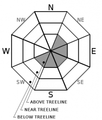
-
Likelihood ?CertainVery LikelyLikelyPossible
 Unlikely
 -
Size ?HistoricVery LargeLargeSmall

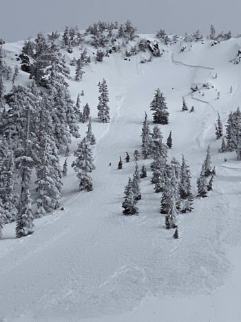
Continue to approach steep leeward slopes above treeline with caution. If you are going high, pay attention to terrain and blowing snow. There may be some isolated wind slabs out there. Blocking and cracking snow are signs that wind slabs have or are forming.
Recent Observations
In the last 24 hours, temperatures near treeline on Mount Shasta have ranged from 13 to 29 degrees. Winds were variable and light.
Since March 27th, we have received near 12 inches of new snow. During and after this new snow, north and west winds blew continuously at 15-20 mi/hr for a period of about 30 hours. Some small wind slab avalanches occurred Monday night. Temperatures and solar radiation have started a melt-freeze cycle on the snowpack at lower elevations. Expect punchy, wind affected snow up higher.
Weather and Current Conditions
Weather Summary
Today and tomorrow expect clear, sunny weather. Winds could be strong up near the summit, but generally they will be light to moderate and out of the northwest and west. Temperatures near treeline should be just above freezing.
We are still on track to receive over an inch of precipitable water this weekend. Snow levels are looking to be around 4,000 ft.
24 Hour Weather Station Data @ 4:00 AM
| Weather Station | Temp (°F) | Wind (mi/hr) | Snow (in) | Comments | ||||||||
|---|---|---|---|---|---|---|---|---|---|---|---|---|
| Cur | Min | Max | Avg | Avg | Max Gust | Dir | Depth | New | Water Equivalent | Settlement | ||
| Mt. Shasta City (3540 ft) | 41 | 39 | 46 | 43 | 3 | |||||||
| Sand Flat (6750 ft) | 11 | 11 | 30 | 21 | 49 | 0 | 0 | 0 | ||||
| Ski Bowl (7600 ft) | 14 | 11 | 29.5 | 18.5 | 81.9 | 0 | 0 | 0 | ||||
| Gray Butte (8000 ft) | 15.5 | 13 | 26.5 | 18 | 6 | 31 | ESE | |||||
| Castle Lake (5870 ft) | 18.5 | 18.5 | 34.5 | 24.5 | 40.2 | 0 | 0.2 | |||||
| Mount Eddy (6509 ft) | 16 | 16 | 29 | 21 | 3 | 13 | SE | 58.5 | 0 | 1.1 | ||
| Ash Creek Bowl (7250 ft) | down | |||||||||||
| Ash Creek Ridge (7895 ft) | down |
Two Day Mountain Weather Forecast
Produced in partnership with the Medford NWS
| For 7000 ft to 9000 ft | |||
|---|---|---|---|
|
Thursday (4 a.m. to 10 p.m.) |
Thursday Night (10 p.m. to 4 a.m.) |
Friday (4 a.m. to 10 p.m.) |
|
| Weather | Sunny. | Mostly clear. | Mostly sunny. |
| Temperature (°F) | 34 | 19 | 36 |
| Wind (mi/hr) | North 0-5 | Northwest 5-10 | Northwest 5-10 |
| Precipitation SWE / Snowfall (in) | 0.00 / 0 | 0.00 / 0 | 0.00 / 0 |
| For 9000 ft to 11000 ft | |||
| Thursday | Thursday Night | Friday | |
| Weather | Sunny. | Mostly clear. Breezy. Low wind chills. | Mostly sunny. Windy. Low wind chills. |
| Temperature (°F) | 14 | 13 | 20 |
| Wind (mi/hr) | Northwest 10-15 | West 15-20 | Northwest 20-25 |
| Precipitation SWE / Snowfall (in) | 0.00 / 0 | 0.00 / 0 | 0.00 / 0 |
Season Precipitation for Mount Shasta City
| Period | Measured (in) | Normal (in) | Percent of Normal (%) |
|---|---|---|---|
| From Oct 1, 2025 (the wet season) | 15.17 | 35.57 | 43 |
| Month to Date (since Jun 1, 2026) | 0.00 | 0.11 | 0 |
| Year to Date (since Jan 1, 2026) | 6.24 | 20.36 | 31 |

