

You are here
Avalanche Forecast for 2020-04-04 06:20
- EXPIRED ON April 5, 2020 @ 6:20 amPublished on April 4, 2020 @ 6:20 am
- Issued by Nick Meyers - Shasta-Trinity National Forest
Bottom Line
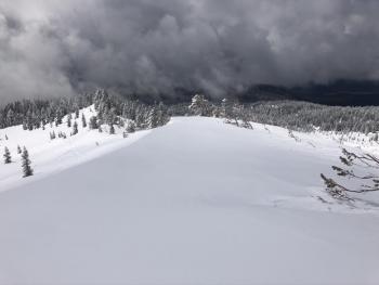
A robust spring storm will impact the mountains over the next 48 hours. Southerly flow will bring periods of heavy precipitation and windy conditions. Avalanche risk will increase as new snow begins to accumulate and strong wind impacts alpine terrain. New snow will rest on top of smooth, firm bed surfaces. Natural and human triggered avalanches are increasingly likely as we move through the weekend. Mindful terrain choice is of vital importance. Please, be safe.


Avalanche Problem 1: Wind Slab
-
Character ?

-
Aspect/Elevation ?
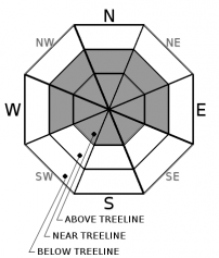
-
Likelihood ?CertainVery LikelyLikelyPossible
 Unlikely
 -
Size ?HistoricVery LargeLargeSmall

Strong winds out of the south/southwest will gradually increase today along with new snow. Near and above treeline will experience active wind loading. Those aspects on the top half of the compass will be the most dangerous. Don't rule out other aspects and cross-loading too. People, you must pay attention this weekend. Avoid all wind loaded slopes steeper than 30 degrees. Seek out those small test slopes and stomp on them. If you see small slabs, shooting cracks or perhaps hear some whoomphing, you could be entering the danger zone. The safest bet? Avoid avalanche terrain as this weekend's storm builds.
Avalanche Problem 2: Storm Slab
-
Character ?

-
Aspect/Elevation ?
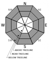
-
Likelihood ?CertainVery LikelyLikelyPossible
Unlikely
-
Size ?HistoricVery LargeLargeSmall
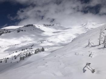
For the beginning of this weekend's weather cycle, storm slabs will be of low concern. If and when you observe more than 6 inches of fresh snow on top of our existing, smooth and firm bed surfaces, you'll need to be mindful for storm slab avalanches. This type of avalanche is found in below treeline and protected, near treeline areas. Ski cut results on small, inconsequential slopes or natural activity on indicator slopes are often the best clues a storm slab problem exists. As the avalanche risk increases this weekend, mindful terrain choice will be imperative.
Forecast Discussion
COVID-19 Information - Updated 4.3.2020
A state wide shelter-in-place order exists for ALL citizens. It is critical that we comply with this order. We recommend exercising close to home and complying with local and state guidance. We know what you're thinking...fresh snow in the mountains, let's go! It makes us cringe to say "locals only", but perhaps now is the time. Please, do no travel for your recreation needs.
At the Mount Shasta Avalanche Center, we always encourage people to get information before planning or heading out for a day in the backcountry. We emphasize that you need to match your plan to the current conditions. Usually, we talk about current snow, weather and avalanche conditions. These are not usual times: now, you need to think about public health conditions.
If you choose to recreate in the mountains, remember your actions may impact others. Please enjoy the backcountry safely, and keep our communities, medical and emergency services professionals, and fellow backcountry users in mind when you consider your terrain choices.
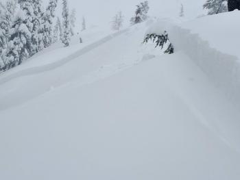
Recent Observations
- In the last 24 hours, temperatures at treeline have ranged from 14 to 35 deg F.
- We've received no new snow
- Wind average 10 mi/hr with gusts to 25 mi/hr at 8,000 feet, west/northwest
- Minor roller balls and surface sloughing on protected, sunny east and south aspects below and near treeline
- Grey Rocks (Sacramento drainage) snow survey course yielded average height of snow of 57" with 21.5" SWE (snow/water equivalent)
- Snow surfaces are smooth and firm. Solar aspects softened early afternoon
- Most lakes are still frozen. Tree wells are showing. Small streams are running and exposed.
Weather and Current Conditions
Weather Summary
A winter storm warning is in effect until 5PM PDT Sunday. We're off to a slow start, but this morning we are staring down the barrel of a stormy weekend expected to bring just over 2 inches of precipitation to the area. Southerly flow may provide for periods of heavy precipitation. While snow levels are expected to sit just above 4,000 feet, we could see snow to town. Being it's April, impacts at lower elevations will be minimal. On the mountain however, it's going to be wintry. Strong southerly wind will combine with ample snowfall and we could see 1-2 feet of new snow by next week. Dry conditions will return through the end of next week.
24 Hour Weather Station Data @ 4:00 AM
| Weather Station | Temp (°F) | Wind (mi/hr) | Snow (in) | Comments | ||||||||
|---|---|---|---|---|---|---|---|---|---|---|---|---|
| Cur | Min | Max | Avg | Avg | Max Gust | Dir | Depth | New | Water Equivalent | Settlement | ||
| Mt. Shasta City (3540 ft) | 33 | 29 | 55 | 40 | 3 | N | ||||||
| Sand Flat (6750 ft) | 26 | 14 | 37 | 28 | 48 | 0 | 0 | 1 | ||||
| Ski Bowl (7600 ft) | 24 | 14 | 35 | 26 | 80.8 | 0 | 0 | .3 | ||||
| Gray Butte (8000 ft) | 22 | 15.5 | 34 | 25 | 10 | 25 | WNW | |||||
| Castle Lake (5870 ft) | 29 | 21 | 42 | 32 | 39.3 | 0 | .5 | |||||
| Mount Eddy (6509 ft) | 27.5 | 18 | 35 | 27.5 | 2 | 10 | WSW | 57.8 | 0.2 | .6 | ||
| Ash Creek Bowl (7250 ft) | down | |||||||||||
| Ash Creek Ridge (7895 ft) | down |
Two Day Mountain Weather Forecast
Produced in partnership with the Medford NWS
| For 7000 ft to 9000 ft | |||
|---|---|---|---|
|
Saturday (4 a.m. to 10 p.m.) |
Saturday Night (10 p.m. to 4 a.m.) |
Sunday (4 a.m. to 10 p.m.) |
|
| Weather | Snow. Slight chance of thunderstorms this afternoon with small hail. Snow level near 4,100 feet. | Snow. Snow level near 4,500 feet. | Snow. Breezy. Scattered thunderstorms possible. Snow level near 4,400 feet. |
| Temperature (°F) | 29 | 27 | 29 |
| Wind (mi/hr) | South 10-15 | South 10-15 | South 10-15 |
| Precipitation SWE / Snowfall (in) | 0.47 / 3-6 | 0.55 / 3-7 | 0.70 / 4-10 |
| For 9000 ft to 11000 ft | |||
| Saturday | Saturday Night | Sunday | |
| Weather | Snow. Some thunder is also possible. Windy. | Snow. Windy. | Snow. Some thunder also possible. Windy. |
| Temperature (°F) | 18 | 13 | 14 |
| Wind (mi/hr) | Southwest 20-30 | Southwest 30-40 | South 30-40 |
| Precipitation SWE / Snowfall (in) | 0.47 / 5-9 | 0.55 / 7-11 | 0.70 / 9-13 |
Season Precipitation for Mount Shasta City
| Period | Measured (in) | Normal (in) | Percent of Normal (%) |
|---|---|---|---|
| From Oct 1, 2025 (the wet season) | 15.17 | 35.81 | 42 |
| Month to Date (since Jun 1, 2026) | 0.00 | 0.35 | 0 |
| Year to Date (since Jan 1, 2026) | 6.24 | 20.60 | 30 |

