

You are here
Avalanche Forecast for 2020-04-09 06:21
- EXPIRED ON April 10, 2020 @ 6:21 amPublished on April 9, 2020 @ 6:21 am
- Issued by Nick Meyers - Shasta-Trinity National Forest
Bottom Line
Today will be the warmest day of the week. Above freezing overnight temperatures and very warm daytime high's raise concern for loose wet avalanches on those sunny, southerly aspects. The recent storm snow has settled out well but surface layers of the snow still remain heavy and wet. Human triggered, loose-wet avalanches are possible.


Avalanche Problem 1: Loose Wet
-
Character ?

-
Aspect/Elevation ?
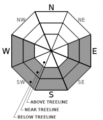
-
Likelihood ?CertainVery LikelyLikelyPossible
 Unlikely
 -
Size ?HistoricVery LargeLargeSmall

Poor overnight re-freeze and above normal daytime temperatures will contribute toward a chance for loose-wet avalanches today. Heavy, mushy, unconsolidated snow surfaces exist, despite about 6 inches (15 cm) of storm snow settlement. Loose wet avalanches may not be big enough to bury you, but could sweep you into undesirable terrain. If you see rollerballs and/or pinwheels occurring naturally or off your ski turns, it's time to head back to the barn or pick another slope that is less sun affected. Loose-wet avalanches often start at a point and entrain more snow as they move downhill. These type of avalanches are usually small and harmless, but can gain significant size and momentum on large slopes with a long fetch.
Avalanche Problem 2: Cornice
-
Character ?

-
Aspect/Elevation ?
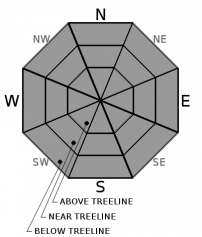
-
Likelihood ?CertainVery LikelyLikelyPossible
Unlikely
-
Size ?HistoricVery LargeLargeSmall
Any remaining cornices along ridgelines/bowls out there will become weak during this period of warm weather. Several crumbling cornices were observed yesterday. This is the time of year when they begin to break off. Don't be part of that. Simply, identify terra firma by looking for rocks and trees sticking up through the snowpack and plan your travel route accordingly. Cornices can and will break without any warning and can often fracture back further than expected. Hairy side up folks!
Forecast Discussion
The Shasta/Trinity National Forest is under COVID-19 Restrictions. Please obey. It takes a village.
Recent Observations
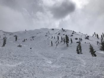
- Yesterday was a warm one but breezy conditions kept loose wet snow instabilities intact.
- Blowing snow was observed spooling off ridgelines on the upper mountain due to strong northeasterly wind. Heavy, wet snow below 11,000 feet was not conducive for wind transport.
- Near treeline temperatures peaked at 46.5 degrees yesterday from 1600 to 1800 hours. Today will be warmer. Temperatures have remained well above freezing throughout the night, dropping only to 40.5 degrees.
- The upper snowpack is moist and sticky. Numerous rollerballs and small point releases were seen on steep east, south and west facing aspects below and near treeline.
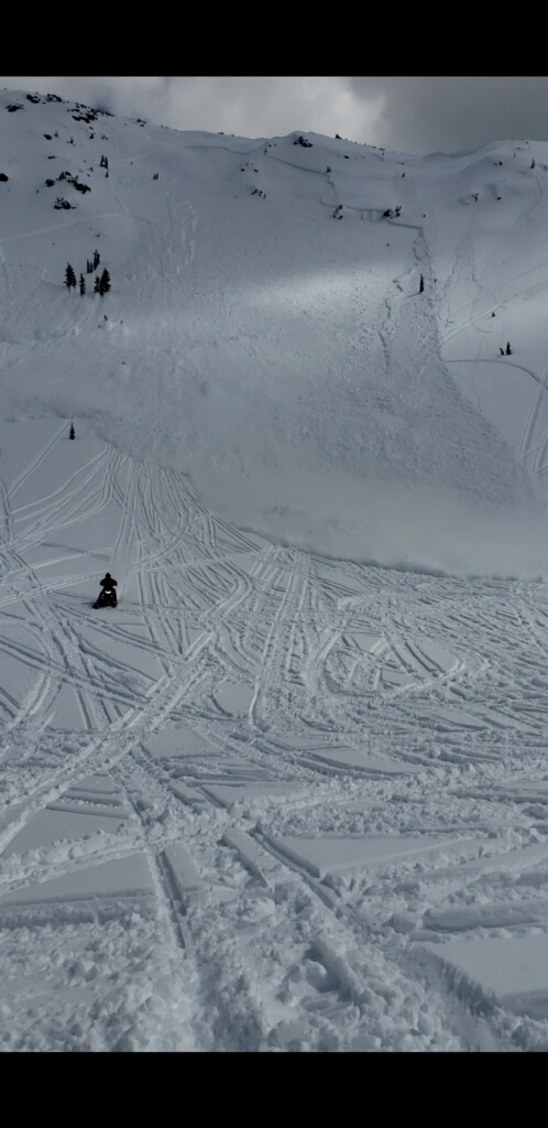
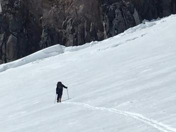
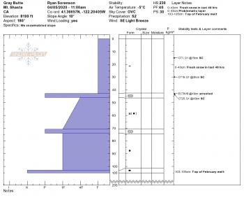
- Old crown lines continue to be found from the recent avalanche cycle previously in the week, including a report (picture below) of an avalanche outrun by a snowmobiler. Nobody was caught or injured. Location looks like the northwest bowl of Ash Creek Butte.
Weather and Current Conditions
Weather Summary
It's going to be high and dry with full sun today. Warmer than normal conditions are expected with peak temperatures for the week. Afternoon high's will be 15 to 20 degrees above normal. Above treeline in exposed areas and high in the alpine, anticipate north/northeasterly wind, 10 to 20 mi/hr with gusts higher. Deep northerly flow continues over the region through next week, meaning dry conditions and temps above normal. Wind will persist through the weekend.
24 Hour Weather Station Data @ 4:00 AM
| Weather Station | Temp (°F) | Wind (mi/hr) | Snow (in) | Comments | ||||||||
|---|---|---|---|---|---|---|---|---|---|---|---|---|
| Cur | Min | Max | Avg | Avg | Max Gust | Dir | Depth | New | Water Equivalent | Settlement | ||
| Mt. Shasta City (3540 ft) | 37 | 37 | 71 | 53.5 | 3 | N | ||||||
| Sand Flat (6750 ft) | 34 | 28 | 54 | 40 | 55 | 0 | 0 | 5 | ||||
| Ski Bowl (7600 ft) | 44.5 | 37 | 46.5 | 42.5 | 90.8 | 0 | 0 | 5.2 | ||||
| Gray Butte (8000 ft) | 43.5 | 36.5 | 46.5 | 42.5 | 19 | 43 | E | |||||
| Castle Lake (5870 ft) | 41 | 38.5 | 58.5 | 50 | 48.3 | 0 | 4.2 | |||||
| Mount Eddy (6509 ft) | 41 | 35 | 55 | 46 | 2 | 10 | WSW | 65.9 | 0 | 5.6 | ||
| Ash Creek Bowl (7250 ft) | down | |||||||||||
| Ash Creek Ridge (7895 ft) | down |
Two Day Mountain Weather Forecast
Produced in partnership with the Medford NWS
| For 7000 ft to 9000 ft | |||
|---|---|---|---|
|
Thursday (4 a.m. to 10 p.m.) |
Thursday Night (10 p.m. to 4 a.m.) |
Friday (4 a.m. to 10 p.m.) |
|
| Weather | Sunny. | Clear. | Sunny. |
| Temperature (°F) | 56 | 35 | 52 |
| Wind (mi/hr) | Northeast 5-10 | Northwest 5-10 | Northwest 5-10 |
| Precipitation SWE / Snowfall (in) | 0.00 / 0 | 0.00 / 0 | 0.00 / 0 |
| For 9000 ft to 11000 ft | |||
| Thursday | Thursday Night | Friday | |
| Weather | Sunny. Windy. | Clear. Windy. | Sunny. Windy. |
| Temperature (°F) | 34 | 31 | 32 |
| Wind (mi/hr) | East/Northeast 20-30 | North/Northeast 15-20 | North 15-20 |
| Precipitation SWE / Snowfall (in) | 0.00 / 0 | 0.00 / 0 | 0.00 / 0 |
Season Precipitation for Mount Shasta City
| Period | Measured (in) | Normal (in) | Percent of Normal (%) |
|---|---|---|---|
| From Oct 1, 2025 (the wet season) | 17.17 | 36.37 | 47 |
| Month to Date (since Jun 1, 2026) | 2.00 | 0.91 | 220 |
| Year to Date (since Jan 1, 2026) | 8.24 | 21.16 | 39 |

