

You are here
Avalanche Forecast for 2020-04-11 05:54
- EXPIRED ON April 12, 2020 @ 5:54 amPublished on April 11, 2020 @ 5:54 am
- Issued by Nick Meyers - Shasta-Trinity National Forest
Bottom Line
We are back to NORMAL CAUTION and LOW danger for the forecast area. Temperatures will remain above normal but cooler than we've observed the past few days. Northwesterly wind will increase today over higher terrain. Uneven and mushy snow surfaces dominate. Watch for rockfall on the upper mountain.


Avalanche Problem 1: Normal Caution
-
Character ?

-
Aspect/Elevation ?
-
Likelihood ?CertainVery LikelyLikelyPossible
 Unlikely
 -
Size ?HistoricVery LargeLargeSmall

Last week we had several feet of new snow and cold weather immediately followed by unseasonably warm, above normal temperatures. A few loose-wet avalanches occurred and plenty of roller balls and big pinwheels. Currently, the snowpack is looking pretty darn intact out there with over a foot of settlement. Use normal caution if traveling in the backcountry. Keep your eyes peeled for potentially fragile cornices, especially on the west side. For the loose wet avalanches, protected SE-S-SW-W facing slopes should be approached with caution on warm days, mid to late afternoon. Look for early signs of loose wet avalanches like rollerballs and pinwheels. If you see those, head back to the barn or pick a different slope. Always carry proper rescue equipment and most importantly, know how to use it.
Forecast Discussion
The Mount Shasta Avalanche Center will shut its doors this Sunday, April 12th. We will issue our spring statement at that time and see you all over again next year. We will not be publishing climbing condition updates until the statewide state-at-home order has been lifted. Local trailheads continue to see out of town visitors, especially at Bunny Flat. The State of California is still under COVID-19 Restrictions. All you powder gangsters and feral corn harvesters out there, please for once, follow the rules.
Recent Observations
- In the past 24 hours, temperatures at treeline reached a high of 54 degrees and a low of 38.
- Variable wind has averaged 4 mi/hr with gusts to 18 mi/hr. Heavy, wet snow is not available for wind transport.
- Snow surfaces remain melt runneled, punchy, sticky, heavy and moist with continued poor overnight re-freeze.
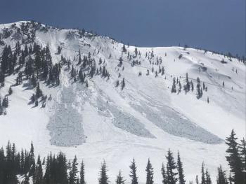
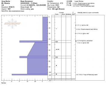
- Several decent sized loose wet avalanches were observed on a west facing aspect of Gray Butte, near treeline terrain.
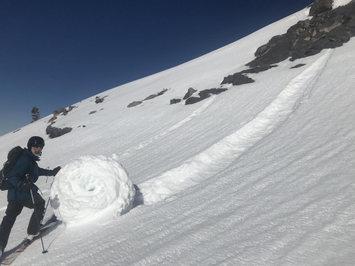
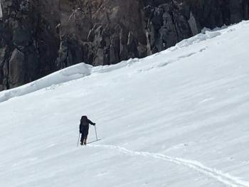
- In steeper terrain, roller balls and pinwheels observed on protected, sunny below and near treeline slopes, including this human sized whopper pictured below!
Weather and Current Conditions
Weather Summary
Unseasonably warm temperatures the last couple days will trend cooler. No major weather is on the horizon and warm and dry conditions are expected across the area into next week. Expect a few clouds with gusty northerly winds over higher terrain this weekend.
24 Hour Weather Station Data @ 4:00 AM
| Weather Station | Temp (°F) | Wind (mi/hr) | Snow (in) | Comments | ||||||||
|---|---|---|---|---|---|---|---|---|---|---|---|---|
| Cur | Min | Max | Avg | Avg | Max Gust | Dir | Depth | New | Water Equivalent | Settlement | ||
| Mt. Shasta City (3540 ft) | 48 | 45 | 70 | 56.5 | 3 | |||||||
| Sand Flat (6750 ft) | 33 | 32 | 53 | 42 | 48 | 0 | 0 | 2 | ||||
| Ski Bowl (7600 ft) | 40 | 38 | 54 | 45 | 83.9 | 0 | 0 | 3.8 | ||||
| Gray Butte (8000 ft) | 42 | 42 | 50.5 | 46 | 4 | 18 | E | |||||
| Castle Lake (5870 ft) | 39 | 35 | 60 | 48 | 42.7 | 2 | 0 | |||||
| Mount Eddy (6509 ft) | 40.5 | 40 | 53.5 | 46.5 | 2 | 9 | SE | 59.3 | 0 | 2.8 | ||
| Ash Creek Bowl (7250 ft) | down | |||||||||||
| Ash Creek Ridge (7895 ft) | down |
Two Day Mountain Weather Forecast
Produced in partnership with the Medford NWS
| For 7000 ft to 9000 ft | |||
|---|---|---|---|
|
Saturday (4 a.m. to 10 p.m.) |
Saturday Night (10 p.m. to 4 a.m.) |
Sunday (4 a.m. to 10 p.m.) |
|
| Weather | Sunny. | Partly cloudy | Partly cloudy |
| Temperature (°F) | 50 | 28 | 48 |
| Wind (mi/hr) | Northwest 10-15 | North 10-15 | Northeast 5-10 |
| Precipitation SWE / Snowfall (in) | 0.00 / 0 | 0.00 / 0 | 0.00 / 0 |
| For 9000 ft to 11000 ft | |||
| Saturday | Saturday Night | Sunday | |
| Weather | Sunny and windy. | Partly cloudy, windy. | Partly cloudy and windy. |
| Temperature (°F) | 30 | 26 | 26 |
| Wind (mi/hr) | Northwest 25-30 | North 30-35 | North 20-25 |
| Precipitation SWE / Snowfall (in) | 0.00 / 0 | 0.00 / 0 | 0.00 / 0 |
Season Precipitation for Mount Shasta City
| Period | Measured (in) | Normal (in) | Percent of Normal (%) |
|---|---|---|---|
| From Oct 1, 2025 (the wet season) | 17.17 | 36.58 | 47 |
| Month to Date (since Jun 1, 2026) | 2.00 | 1.12 | 179 |
| Year to Date (since Jan 1, 2026) | 8.24 | 21.37 | 39 |

