

You are here
Avalanche Forecast for 2020-12-15 06:00
- EXPIRED ON December 16, 2020 @ 6:00 amPublished on December 15, 2020 @ 6:00 am
- Issued by Aaron Beverly - Mount Shasta Avalanche Center
Bottom Line
Avalanche danger is LOW. Around 8 inches of new snow can be found in areas near and below treeline. Moraines, ridges, and start zones above treeline are still devoid of snow. A warm, wet storm is on deck for tomorrow.


Avalanche Problem 1: Normal Caution
-
Character ?

-
Aspect/Elevation ?

-
Likelihood ?CertainVery LikelyLikelyPossible
 Unlikely
Avalanche danger is low, but don't be complacent. Keep your mind in the game. Why is it low? Where has the wind been blowing? Where would wind slabs be? Am I in or near avalanche terrain? How would I travel safely through it with a group? How will the existing snowpack respond to two more feet of snow? Ask yourself these questions as you travel in the backcountry. Develop your awareness. Practice your skills.
Recent Observations
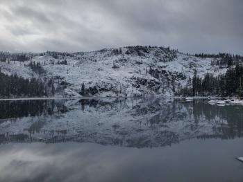
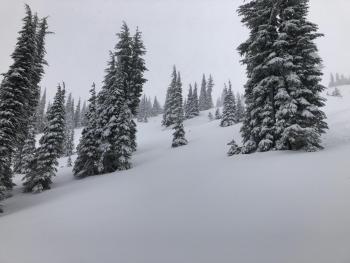
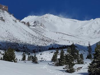
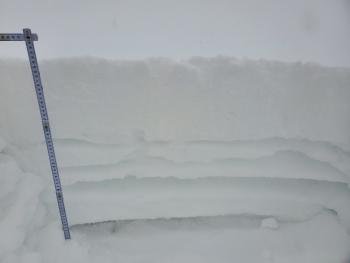
Since Friday, December 11th, Mount Shasta has received about 8 inches of new snow. Gullies and sheltered areas near and below treeline are still holding this low density snow. Above treeline, you'll find some usable, chalky, slightly wind affected snow in gullies, but moraines and ridges are scoured and icy. North and northwest winds have blown most of the new snow away. Though some thin slabishness can be found in lee areas, no concerning signs of wind slabs have been found. No signs of avalanche danger have been seen. There just isn't enough snow in steep areas yet.
Some good turns can be found in fresh new snow near and below treeline, and the chalky snow above treeline. If you value your skis and ACLs, though, ski gently. Beware of hidden rocks. Shots to the core are likely.
Weather and Current Conditions
Weather Summary
I wish I could bring tidings of a game changing storm on the way, but persistent high pressure out in the Pacific keeps us just outside the southern edge of all the precipitation rolling through the pacific northwest.
Today, a weak front will push through bringing some flurries of snow with no accumulation.
Tomorrow's storm could bring as much as 0.88 inches of water, but snow levels are going to be high - higher than we want them. Near treeline elevations may see up to 4 inches of wet snow. Westerly winds will be strong.
24 Hour Weather Station Data @ 5:00 AM
| Weather Station | Temp (°F) | Wind (mi/hr) | Snow (in) | Comments | ||||||||
|---|---|---|---|---|---|---|---|---|---|---|---|---|
| Cur | Min | Max | Avg | Avg | Max Gust | Dir | Depth | New | Water Equivalent | Settlement | ||
| Mt. Shasta City (3540 ft) | 32 | 30 | 41 | 34 | 2 | N | ||||||
| Sand Flat (6750 ft) | 29 | 15 | 29 | 23 | Not reporting accurate snow depth and SWE | |||||||
| Ski Bowl (7600 ft) | 35 | 16.5 | 36.5 | 24.5 | 19.2 | 0 | 0 | 0.4 | ||||
| Gray Butte (8000 ft) | 32 | 16.5 | 32 | 22.5 | 7 | 43 | NW | |||||
| Castle Lake (5870 ft) | 35 | 22 | 35 | 26 | 4.5 | 0 | 0 | |||||
| Mount Eddy (6509 ft) | 30.5 | 19.5 | 30.5 | 24 | 2 | 5 | WSW | 13.3 | 0 | 1.2 | ||
| Ash Creek Bowl (7250 ft) | 28.5 | 18.5 | 29 | 22 | 20.9 | 0 | 0.5 | |||||
| Ash Creek Ridge (7895 ft) | 30 | 15 | 30 | 20 |
Two Day Mountain Weather Forecast
Produced in partnership with the Medford NWS
| For 7000 ft to 9000 ft | |||
|---|---|---|---|
|
Tuesday (4 a.m. to 10 p.m.) |
Tuesday Night (10 p.m. to 4 a.m.) |
Wednesday (4 a.m. to 10 p.m.) |
|
| Weather | A chance of snow after 10 a.m., mixing with rain after 1 p.m. Mostly cloudy. Chance of precipitation is 40%. | A slight chance of rain and snow before 7 p.m., then a slight chance of snow between 7 p.m. and 10 p.m. Mostly cloudy. Chance of precipitation is 20%. | Snow after 10 a.m. High near 33. Breezy. Chance of precipitation is 90%. |
| Temperature (°F) | 34 | 30 | 33 |
| Wind (mi/hr) | Southwest 5-10 | Southwest 5-10 | South 10-15 |
| Precipitation SWE / Snowfall (in) | 0.00 / 0 | 0.00 / 0 | 0.63 / 2-3 |
| For 9000 ft to 11000 ft | |||
| Tuesday | Tuesday Night | Wednesday | |
| Weather | A 40 percent chance of snow, mainly between 10 a.m. and 4 p.m. Mostly cloudy. Windy. | A 20 percent chance of snow before 10 p.m. Mostly cloudy. Windy. | Snow after 10 a.m. The snow could be heavy at times. Low wind chills. Chance of precipitation is 90%. |
| Temperature (°F) | 28 | 26 | 30 |
| Wind (mi/hr) | West 30-35 | Northwest 35-40 | West 35-40 |
| Precipitation SWE / Snowfall (in) | 0.00 / 0 | 0.00 / 0 | 0.63 / 3-7 |
Season Precipitation for Mount Shasta City
| Period | Measured (in) | Normal (in) | Percent of Normal (%) |
|---|---|---|---|
| From Oct 1, 2025 (the wet season) | 2.05 | 10.68 | 19 |
| Month to Date (since Jun 1, 2026) | 0.35 | 3.32 | 11 |
| Year to Date (since Jan 1, 2026) | 14.96 | 38.68 | 39 |

