

You are here
Avalanche Forecast for 2020-12-16 06:30
- EXPIRED ON December 17, 2020 @ 6:30 amPublished on December 16, 2020 @ 6:30 am
- Issued by Aaron Beverly - Mount Shasta Avalanche Center
Bottom Line
Intense winds and precipitation are expected today, mostly after 4 p.m. Avalanche danger will increase from LOW to MODERATE late tonight as strong southwest winds combine with up to 14 inches of new snow to form wind slabs. Approach steep leeward slopes with caution.


Avalanche Problem 1: Wind Slab
-
Character ?

-
Aspect/Elevation ?
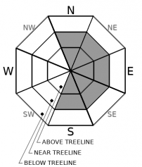
-
Likelihood ?CertainVery LikelyLikelyPossible
 Unlikely
 -
Size ?HistoricVery LargeLargeSmall

The incoming storm will dump most of its precipitation after 4 p.m. so avalanche concerns will grow late into the night. These concerns will be in very specific areas: steep leeward slopes where there is enough prior snow to provide a smooth bed surface. There may be areas on Gray Butte and Ash Creek Butte that fit this description. If you find yourself in places like these, evaluate terrain carefully. Cracking or blocking snow is a sign that a wind slab problem may exist.
Forecast Discussion
When you wake up tomorrow morning and see a white mountain, remember that prior to today's storm, many rocks were exposed above treeline. These will now be hidden hazards. Slide and ride with caution.
Recent Observations
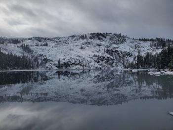
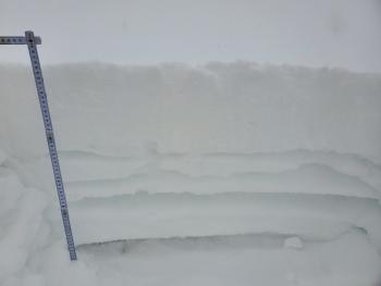
Mount Shasta received about 8 inches of new snow last weekend. Most of this will be found in sheltered areas near and below treeline. Above treeline, you'll find some usable, chalky, slightly wind-affected snow in gullies, but many moraines, ridges, and start zones hold more rock than snow, though there are exceptions. The west facing aspect of Gray Butte and the slopes below Red Banks and the Trinity Chutes are mostly snow.
Up to 8 inches of wet snow can be found at Castle Lake. Rocks, chaparral, and forest debris are still exposed. The lake is not frozen.
Weather and Current Conditions
Weather Summary
Predicted snow levels and precipitation amounts have gotten better for today's incoming storm. Plan on the snow level to be 5,000 ft for this one, though there is some indication that the level could drop to 4,000 ft during the more intense part of the storm. This should be good news for the Nordic Center and Mount Shasta Ski Park.
Total precipitation predicted is 0.96 inches of water. This should translate to 6 to 14 inches of snow. Most of this will fall between 4 and 10 p.m. so expect some intense rain and snowfall at times. Southwest winds may reach gale force speeds above treeline.
The storm will linger until about 10 a.m. tomorrow morning and, unfortunately, that looks to be mostly it until the end of the year.
24 Hour Weather Station Data @ 5:00 AM
| Weather Station | Temp (°F) | Wind (mi/hr) | Snow (in) | Comments | ||||||||
|---|---|---|---|---|---|---|---|---|---|---|---|---|
| Cur | Min | Max | Avg | Avg | Max Gust | Dir | Depth | New | Water Equivalent | Settlement | ||
| Mt. Shasta City (3540 ft) | 28 | 28 | 39 | 32.5 | 0 | N | ||||||
| Sand Flat (6750 ft) | 27 | 25 | 36 | 31 | Not reporting accurate snow depth and SWE | |||||||
| Ski Bowl (7600 ft) | 31.5 | 28.5 | 37.5 | 33.5 | 18.5 | 0 | 0 | 0.6 | ||||
| Gray Butte (8000 ft) | 33.5 | 27.5 | 34 | 31.5 | 23 | 55 | WNW | |||||
| Castle Lake (5870 ft) | 31 | 27 | 40 | 33 | 3.8 | 0 | 0.7 | |||||
| Mount Eddy (6509 ft) | 32.5 | 28.5 | 39 | 34 | 2 | 6 | WSW | 12 | 0 | 0.9 | ||
| Ash Creek Bowl (7250 ft) | 30 | 28.5 | 34 | 31 | 20.1 | 0 | 0.7 | |||||
| Ash Creek Ridge (7895 ft) | 34 | 26 | 34 | 30 |
Two Day Mountain Weather Forecast
Produced in partnership with the Medford NWS
| For 7000 ft to 9000 ft | |||
|---|---|---|---|
|
Wednesday (4 a.m. to 10 p.m.) |
Wednesday Night (10 p.m. to 4 a.m.) |
Thursday (4 a.m. to 10 p.m.) |
|
| Weather | Snow after 10 a.m. Temperatures dropping after 9 a.m. Windy. Chance of precipitation is 80%. | Snow before 10 p.m., then snow showers, mainly after 10 p.m. Breezy. Chance of precipitation is 90%. | Snow showers likely, mainly before 10 a.m. Mostly cloudy. Chance of precipitation is 60%. |
| Temperature (°F) | 25 | 26 | 28 |
| Wind (mi/hr) | South 10-15 | Southwest 15-20 | Northwest 10-15 |
| Precipitation SWE / Snowfall (in) | 0.16 / 1-2 | 0.73 / 6-8 | 0.06 / 0-0.50 |
| For 9000 ft to 11000 ft | |||
| Wednesday | Wednesday Night | Thursday | |
| Weather | Snow after 10 a.m. The snow could be heavy at times. Windy. Low wind chills. Chance of precipitation is 80%. | Snow before 10 p.m., then snow showers, mainly after 10 p.m. The snow could be heavy at times. Windy. Low wind chills. Chance of precipitation is 90%. | Snow showers likely, mainly before 10 a.m. Mostly cloudy. Windy. Low wind chills. Chance of precipitation is 60%. |
| Temperature (°F) | 17 | 14 | 23 |
| Wind (mi/hr) | Southwest 40-45 | Southwest 40-50 | Northwest 30-35 |
| Precipitation SWE / Snowfall (in) | 0.16 / 1-3 | 0.73 / 7-11 | 0.06 / 0-0.50 |
Season Precipitation for Mount Shasta City
| Period | Measured (in) | Normal (in) | Percent of Normal (%) |
|---|---|---|---|
| From Oct 1, 2025 (the wet season) | 2.09 | 10.94 | 19 |
| Month to Date (since Jul 1, 2026) | 0.39 | 3.58 | 11 |
| Year to Date (since Jan 1, 2026) | 15.00 | 38.94 | 39 |

